TopoQuest Logo
Do you find TopoQuest useful?
Help keep TopoQuest running and adding new maps/features by donating!
Bitcoin:  19c7KJd3qBynnjoSw5npx9KScwjBe4ifkT
Litecoin:  LXs6TkuXGGXo1vDsWCkWVdjQX94eUKd6ui
Home View Maps Find Maps Find Places Resources & Links


Albion NW, Illinois Topographic Map

USGS Map Title: Albion NW, IL
USGS Map MRC: 38088D2
DRG (GeoTIFF) Download: o38088d2.tif


Neighboring USGS Topographic Map Quads:


  Enterprise, IL  
38088E3
 

  Mount Erie, IL  
38088E2
 

  West Salem, IL  
38088E1
 

  Fairfield, IL  
38088D3
 

  Albion NW, IL  
38088D2
 

  Albion North, IL  
38088D1
 

  Burnt Prairie, IL  
38088C3
 

  Golden Gate, IL  
38088C2
 

  Albion South, IL  
38088C1


Map MRC Location:

N39°
W89°
N39°
W88°
H8 H7 H6 H5 H4 H3 H2 H1
G8 G7 G6 G5 G4 G3 G2 G1
F8 F7 F6 F5 F4 F3 F2 F1
E8 E7 E6 E5 E4 E3 E2 E1
D8 D7 D6 D5 D4 D3 D2 D1
C8 C7 C6 C5 C4 C3 C2 C1
B8 B7 B6 B5 B4 B3 B2 B1
A8 A7 A6 A5 A4 A3 A2 A1
N38°
W89°
N38°
W88°

Albion NW, IL USGS 1:24K Topographic Map Preview:
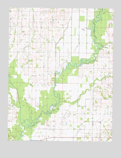
Albion NW, IL USGS Topographic Map
Click on map above to begin viewing in our Map Viewer.

This topographic map contains these locations and features:
Feature Name Type Latitude Longitude GNIS ID View Map
Ash SloughStreamN38.4298°W88.1934°1823818View Map
Base Line BridgeBridgeN38.4645°W88.1375°424603View Map
Bear CreekStreamN38.4923°W88.1398°404017View Map
Bond School (historical)SchoolN38.4542°W88.1292°1725483View Map
Burnt PrairieAreaN38.4009°W88.1303°1808139View Map
Clear Pond DitchCanalN38.4817°W88.1659°406229View Map
Clear Pond SloughStreamN38.4737°W88.1573°1823912View Map
Conway ChurchChurchN38.4012°W88.1581°406492View Map
Conway School (historical)SchoolN38.4006°W88.1709°1823841View Map
Elm RiverStreamN38.3948°W88.2248°407937View Map
Gerber School (historical)SchoolN38.4975°W88.1839°1823862View Map
Golden Gate North Oil FieldOilfieldN38.3853°W88.2387°424931View Map
Gum Corner School (historical)SchoolN38.4145°W88.1487°1823863View Map
Half Moon Oil FieldOilfieldN38.4042°W88.1864°424958View Map
Half Moon PondLakeN38.4063°W88.1893°409637View Map
Half Moon PondLakeN38.4805°W88.1531°409638View Map
Hedge BridgeBridgeN38.3923°W88.2148°424973View Map
Horseshoe PondLakeN38.4632°W88.1421°410582View Map
Lick CreekStreamN38.4537°W88.2409°412052View Map
Lick Creek LateralCanalN38.4453°W88.2442°412062View Map
Locust Grove CemeteryCemeteryN38.4698°W88.2359°412485View Map
Massilon BridgeBridgeN38.4387°W88.1939°425171View Map
Massilon TownhallBuildingN38.4362°W88.2175°1823883View Map
McKendree ChapelChurchN38.4817°W88.2125°413292View Map
McKendrie CemeteryCemeteryN38.4812°W88.2125°1953071View Map
Moore Pond SloughStreamN38.4025°W88.2084°413785View Map
New Massillon (historical)Populated PlaceN38.4381°W88.1964°1823892View Map
Number 4 School (historical)SchoolN38.4823°W88.2031°1823896View Map
Number 7 School (historical)SchoolN38.4362°W88.2175°1823897View Map
Oakwood ChurchChurchN38.3862°W88.1945°414937View Map
Oakwood School (historical)SchoolN38.3862°W88.2031°1823900View Map
Old River IslandIslandN38.4050°W88.1967°415046View Map
Owens CreekStreamN38.3775°W88.2364°415274View Map
Pleasant Hill CemeteryCemeteryN38.4587°W88.1300°1808166View Map
Pleasant Hill Congregational ChurchChurchN38.4584°W88.1300°415829View Map
Pleasant View School (historical)SchoolN38.4367°W88.1534°1823907View Map
Rattlesnake BluffCliffN38.4487°W88.1545°416400View Map
Samaria CemeteryCemeteryN38.4256°W88.1298°1808172View Map
Samaria Missionary Baptist ChurchChurchN38.4259°W88.1298°417914View Map
Thomas Hill CemeteryCemeteryN38.3903°W88.2014°419656View Map
Township of MassilonCivilN38.4269°W88.2033°429339View Map
Turkey RidgeSummitN38.4798°W88.1598°419938View Map
Union Drainage DitchCanalN38.3770°W88.1712°420070View Map
Vandaveer School (historical)SchoolN38.4823°W88.2345°1823925View Map
Village CreekStreamN38.4114°W88.1887°420316View Map
Walker CemeteryCemeteryN38.4712°W88.2211°420399View Map
West ChurchChurchN38.4534°W88.2025°420807View Map
West School (historical)SchoolN38.4450°W88.2081°1823936View Map
West Side Diversion DitchCanalN38.4848°W88.1795°420925View Map
West Village CreekStreamN38.4373°W88.1314°420944View Map

Note: Coordinates in the location and feature list above are referenced to NAD83 datum.


Copyright (C) 2008-2024 Ryan Niemi / Sunset Dynamics ... All Rights Reserved