TopoQuest Logo
Do you find TopoQuest useful?
Help keep TopoQuest running and adding new maps/features by donating!
Bitcoin:  19c7KJd3qBynnjoSw5npx9KScwjBe4ifkT
Litecoin:  LXs6TkuXGGXo1vDsWCkWVdjQX94eUKd6ui
Home View Maps Find Maps Find Places Resources & Links


Stolletown, Illinois Topographic Map

USGS Map Title: Stolletown, IL
USGS Map MRC: 38089F4
DRG (GeoTIFF) Download: o38089f4.tif


Neighboring USGS Topographic Map Quads:


  Pocahontas, IL  
38089G5
 

  Beaver Creek, IL  
38089G4
 

  Pleasant Mound, IL  
38089G3
 

  Saint Rose, IL  
38089F5
 

  Stolletown, IL  
38089F4
 

  Keyesport, IL  
38089F3
 

  Breese, IL  
38089E5
 

  Beckemeyer, IL  
38089E4
 

  Carlyle, IL  
38089E3


Map MRC Location:

N39°
W90°
N39°
W89°
H8 H7 H6 H5 H4 H3 H2 H1
G8 G7 G6 G5 G4 G3 G2 G1
F8 F7 F6 F5 F4 F3 F2 F1
E8 E7 E6 E5 E4 E3 E2 E1
D8 D7 D6 D5 D4 D3 D2 D1
C8 C7 C6 C5 C4 C3 C2 C1
B8 B7 B6 B5 B4 B3 B2 B1
A8 A7 A6 A5 A4 A3 A2 A1
N38°
W90°
N38°
W89°

Stolletown, IL USGS 1:24K Topographic Map Preview:
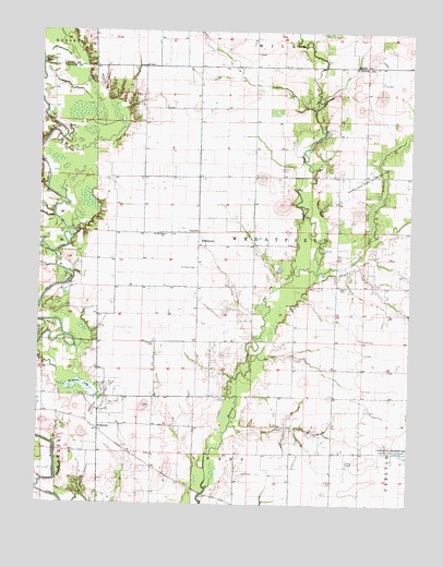
Stolletown, IL USGS Topographic Map
Click on map above to begin viewing in our Map Viewer.

This topographic map contains these locations and features:
Feature Name Type Latitude Longitude GNIS ID View Map
Beckemeyer Dairy FarmLocaleN38.6758°W89.3944°2680757View Map
Big LakeSwampN38.7280°W89.4746°1736360View Map
Carlyle Airpark (historical)AirportN38.6356°W89.3962°1736368View Map
Carlyle North Oil FieldOilfieldN38.6895°W89.3917°424715View Map
Carlyle Oil FieldOilfieldN38.6442°W89.4106°405607View Map
Diekemper DairyLocaleN38.6831°W89.4058°2706241View Map
Flat BranchStreamN38.6862°W89.4067°408434View Map
Ford SchoolSchoolN38.6973°W89.4470°408496View Map
FrogtownLocaleN38.6442°W89.4795°408777View Map
Frogtown LakeSwampN38.6554°W89.4850°408778View Map
Frogtown North Oil FieldOilfieldN38.6523°W89.4801°424907View Map
Hull School (historical)SchoolN38.7303°W89.4376°1736392View Map
Kell School (historical)SchoolN38.6753°W89.4001°1736396View Map
Keyesport PitMineN38.7464°W89.3811°2712299View Map
Lower Ford School (historical)SchoolN38.6684°W89.4520°1736400View Map
Miller School (historical)SchoolN38.6378°W89.4615°1736406View Map
Rudolph CemeteryCemeteryN38.6675°W89.4609°417029View Map
Saint Felicitas CemeteryCemeteryN38.6962°W89.4559°1965729View Map
Saint Felicitas ChurchChurchN38.6964°W89.4579°417274View Map
Saint Peter CemeteryCemeteryN38.6875°W89.4470°417746View Map
SchwierJohn School (historical)SchoolN38.6384°W89.4004°1736414View Map
Shoal Creek CemeteryCemeteryN38.7031°W89.4987°1965720View Map
Sparks Post Office (historical)Post OfficeN38.6862°W89.4467°1810459View Map
StolletownPopulated PlaceN38.6934°W89.4467°419158View Map
The Mound Church (historical)ChurchN38.7262°W89.3806°1736407View Map
The Mound School (historical)SchoolN38.7212°W89.3904°1736408View Map
Township of WheatfieldCivilN38.6974°W89.4265°429923View Map
Weinheimer CemeteryCemeteryN38.7442°W89.4276°1965672View Map
Wheatfield Township Fire Protection DistrictBuildingN38.6973°W89.4470°2640698View Map
Yingst CemeteryCemeteryN38.6828°W89.3965°421576View Map

Note: Coordinates in the location and feature list above are referenced to NAD83 datum.


Copyright (C) 2008-2024 Ryan Niemi / Sunset Dynamics ... All Rights Reserved