TopoQuest Logo
Do you find TopoQuest useful?
Help keep TopoQuest running and adding new maps/features by donating!
Bitcoin:  19c7KJd3qBynnjoSw5npx9KScwjBe4ifkT
Litecoin:  LXs6TkuXGGXo1vDsWCkWVdjQX94eUKd6ui
Home View Maps Find Maps Find Places Resources & Links


Sterling, Utah Topographic Map

USGS Map Title: Sterling, UT
USGS Map MRC: 39111B6
DRG (GeoTIFF) Download: o39111b6.tif


Neighboring USGS Topographic Map Quads:


  Hells Kitchen Canyon SE, UT  
39111C7
 

  Manti, UT  
39111C6
 

  Ephraim, UT  
39111C5
 

  Gunnison, UT  
39111B7
 

  Sterling, UT  
39111B6
 

  Black Mountain, UT  
39111B5
 

  Redmond, UT  
39111A7
 

  Mayfield, UT  
39111A6
 

  Woods Lake, UT  
39111A5


Map MRC Location:

N40°
W112°
N40°
W111°
H8 H7 H6 H5 H4 H3 H2 H1
G8 G7 G6 G5 G4 G3 G2 G1
F8 F7 F6 F5 F4 F3 F2 F1
E8 E7 E6 E5 E4 E3 E2 E1
D8 D7 D6 D5 D4 D3 D2 D1
C8 C7 C6 C5 C4 C3 C2 C1
B8 B7 B6 B5 B4 B3 B2 B1
A8 A7 A6 A5 A4 A3 A2 A1
N39°
W112°
N39°
W111°

Sterling, UT USGS 1:24K Topographic Map Preview:
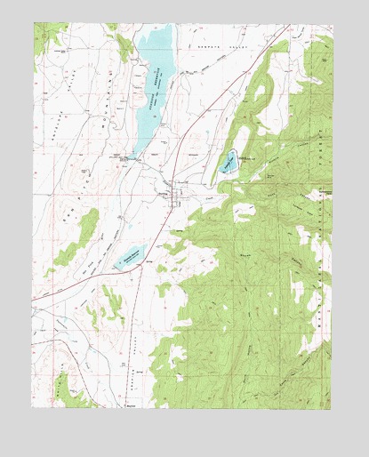
Sterling, UT USGS Topographic Map
Click on map above to begin viewing in our Map Viewer.

This topographic map contains these locations and features:
Feature Name Type Latitude Longitude GNIS ID View Map
Antelope Valley RanchLocaleN39.2408°W111.7363°1438247View Map
Arapien ValleyValleyN39.1602°W111.7074°1438260View Map
Chris CanyonValleyN39.1280°W111.6630°1439723View Map
Danish Field CreekStreamN39.2347°W111.6799°1440262View Map
Forbush CoveBasinN39.1891°W111.6374°1441158View Map
Funk CanyonValleyN39.1989°W111.6655°1441256View Map
Gunnison DamDamN39.2050°W111.7108°1447778View Map
Gunnison ReservoirReservoirN39.2366°W111.6993°1441528View Map
KMXU-FM (Manti)TowerN39.2016°W111.7283°1455781View Map
Lake CanalCanalN39.2264°W111.6630°1442393View Map
Larson DitchCanalN39.1608°W111.7494°1442443View Map
Manti Dump Wildlife Management AreaParkN39.2250°W111.6441°1448641View Map
Manti Meadows Waterfowl Management AreaParkN39.2436°W111.6727°1448643View Map
Morrison MineMineN39.2014°W111.6530°1443603View Map
Ninemile DamDamN39.1700°W111.7158°1447772View Map
Ninemile ReservoirReservoirN39.1742°W111.7092°1443831View Map
Ninemile State Wildlife Management AreaParkN39.1572°W111.6613°1453039View Map
North Hollow Wildlife Management AreaParkN39.1252°W111.6766°1448749View Map
Palisade CampgroundLocaleN39.2033°W111.6569°1448794View Map
Palisade LakeReservoirN39.2047°W111.6690°1447775View Map
Palisade Lake DamDamN39.2033°W111.6724°1447776View Map
Palisade State Boating ParkParkN39.2064°W111.6655°1444166View Map
Rattlesnake PeakSummitN39.1947°W111.6252°1444742View Map
Sanpete County JailBuildingN39.2480°W111.6447°2769023View Map
Sanpete County Sheriffs OfficeBuildingN39.2477°W111.6453°2730378View Map
Sanpete ValleyValleyN39.2339°W111.6813°1445325View Map
Six-Mile Wildlife Management AreaParkN39.1797°W111.6613°1449009View Map
Sixmile CanyonValleyN39.2008°W111.6655°1445623View Map
Sixmile CreekStreamN39.2036°W111.7113°1445626View Map
Snows CanyonValleyN39.1922°W111.6805°1445752View Map
SterlingPopulated PlaceN39.1936°W111.6924°1446134View Map
Sterling CemeteryCemeteryN39.1963°W111.6991°1449068View Map
Sterling Post OfficePost OfficeN39.1953°W111.6929°2769071View Map
The Church of Jesus Christ of Latter Day SaintsChurchN39.1927°W111.6927°1450988View Map
Town of SterlingCivilN39.1933°W111.6904°2413334View Map
Twelvemile CreekStreamN39.1591°W111.7485°1446773View Map

Note: Coordinates in the location and feature list above are referenced to NAD83 datum.


Copyright (C) 2008-2024 Ryan Niemi / Sunset Dynamics ... All Rights Reserved