TopoQuest Logo
Do you find TopoQuest useful?
Help keep TopoQuest running and adding new maps/features by donating!
Bitcoin:  19c7KJd3qBynnjoSw5npx9KScwjBe4ifkT
Litecoin:  LXs6TkuXGGXo1vDsWCkWVdjQX94eUKd6ui
Home View Maps Find Maps Find Places Resources & Links


Blair, Oklahoma Topographic Map

USGS Map Title: Blair, OK
USGS Map MRC: 34099G3
DRG (GeoTIFF) Download: o34099g3.tif


Neighboring USGS Topographic Map Quads:


  Granite, OK  
34099H4
 

  Lake Altus, OK  
34099H3
 

  Lone Wolf, OK  
34099H2
 

  Hester, OK  
34099G4
 

  Blair, OK  
34099G3
 

  Warren, OK  
34099G2
 

  Martha, OK  
34099F4
 

  Altus, OK  
34099F3
 

  Headrick, OK  
34099F2


Map MRC Location:

N35°
W100°
N35°
W99°
H8 H7 H6 H5 H4 H3 H2 H1
G8 G7 G6 G5 G4 G3 G2 G1
F8 F7 F6 F5 F4 F3 F2 F1
E8 E7 E6 E5 E4 E3 E2 E1
D8 D7 D6 D5 D4 D3 D2 D1
C8 C7 C6 C5 C4 C3 C2 C1
B8 B7 B6 B5 B4 B3 B2 B1
A8 A7 A6 A5 A4 A3 A2 A1
N34°
W100°
N34°
W99°

Blair, OK USGS 1:24K Topographic Map Preview:
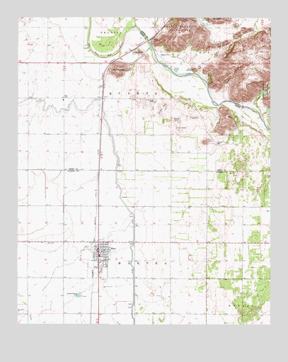
Blair, OK USGS Topographic Map
Click on map above to begin viewing in our Map Viewer.

This topographic map contains these locations and features:
Feature Name Type Latitude Longitude GNIS ID View Map
BlairPopulated PlaceN34.7795°W99.3354°1090245View Map
Blair CemeteryCemeteryN34.7831°W99.3586°2708450View Map
Blair Elementary SchoolSchoolN34.7780°W99.3350°1790562View Map
Blair High SchoolSchoolN34.7782°W99.3349°1790265View Map
Blair LateralCanalN34.8084°W99.3354°1090246View Map
Blair Police DepartmentBuildingN34.7803°W99.3364°2757548View Map
Blair Post OfficePost OfficeN34.7807°W99.3347°1813256View Map
Blair Volunteer Fire DepartmentBuildingN34.7808°W99.3290°2658599View Map
Byrd MountainSummitN34.8540°W99.3251°1090777View Map
Cement GapGapN34.8642°W99.2745°1091139View Map
City ViewPopulated PlaceN34.8415°W99.3520°1100299View Map
Devils CanyonValleyN34.8362°W99.2556°1092056View Map
Elm Fork Red RiverStreamN34.8714°W99.3170°1092583View Map
King MountainSummitN34.8709°W99.2937°1094387View Map
KQTZ-FM (Hobart)TowerN34.8709°W99.2937°1102803View Map
Stewart MountainSummitN34.8540°W99.2879°1098531View Map
Town of BlairCivilN34.7798°W99.3330°2411695View Map
Township of QuartzCivilN34.8445°W99.3698°1825377View Map
Warren Fire DepartmentBuildingN34.7993°W99.2747°2658600View Map
Wisdom CanyonValleyN34.8412°W99.2701°1099929View Map

Note: Coordinates in the location and feature list above are referenced to NAD83 datum.


Copyright (C) 2008-2024 Ryan Niemi / Sunset Dynamics ... All Rights Reserved