TopoQuest Logo
Do you find TopoQuest useful?
Help keep TopoQuest running and adding new maps/features by donating!
Bitcoin:  19c7KJd3qBynnjoSw5npx9KScwjBe4ifkT
Litecoin:  LXs6TkuXGGXo1vDsWCkWVdjQX94eUKd6ui
Home View Maps Find Maps Find Places Resources & Links


Stanley, Idaho Topographic Map

USGS Map Title: Stanley, ID
USGS Map MRC: 44114B8
DRG (GeoTIFF) Download: o44114b8.tif


Neighboring USGS Topographic Map Quads:


  Elk Meadow, ID  
44115C1
 

  Basin Butte, ID  
44114C8
 

  East Basin Creek, ID  
44114C7
 

  Stanley Lake, ID  
44115B1
 

  Stanley, ID  
44114B8
 

  Casino Lakes, ID  
44114B7
 

  Warbonnet Peak, ID  
44115A1
 

  Mount Cramer, ID  
44114A8
 

  Obsidian, ID  
44114A7


Map MRC Location:

N45°
W115°
N45°
W114°
H8 H7 H6 H5 H4 H3 H2 H1
G8 G7 G6 G5 G4 G3 G2 G1
F8 F7 F6 F5 F4 F3 F2 F1
E8 E7 E6 E5 E4 E3 E2 E1
D8 D7 D6 D5 D4 D3 D2 D1
C8 C7 C6 C5 C4 C3 C2 C1
B8 B7 B6 B5 B4 B3 B2 B1
A8 A7 A6 A5 A4 A3 A2 A1
N44°
W115°
N44°
W114°

Stanley, ID USGS 1:24K Topographic Map Preview:
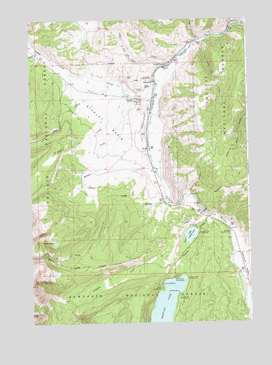
Stanley, ID USGS Topographic Map
Click on map above to begin viewing in our Map Viewer.

This topographic map contains these locations and features:
Feature Name Type Latitude Longitude GNIS ID View Map
Boundary CreekStreamN44.1532°W114.8784°378119View Map
Buckhorn Roadside RestLocaleN44.1571°W114.8937°378418View Map
Chinook Bay CampgroundLocaleN44.1588°W114.9129°379310View Map
City of StanleyCivilN44.2150°W114.9364°2411968View Map
Cleveland CreekStreamN44.1496°W114.8770°379411View Map
Crooked CreekStreamN44.2371°W114.9951°380081View Map
Elkhorn CreekStreamN44.2485°W114.8829°381409View Map
Fishhook CreekStreamN44.1427°W114.9204°396491View Map
Four Aces CreekStreamN44.2360°W114.9073°381956View Map
Glacier View CampgroundLocaleN44.1477°W114.9120°394437View Map
Goat CreekStreamN44.2188°W114.9423°393796View Map
Heyburn Mountain CampgroundLocaleN44.1316°W114.9229°400361View Map
Iron CreekStreamN44.2230°W114.9484°383752View Map
Joes GulchValleyN44.2424°W114.9026°383940View Map
Little Redfish LakeLakeN44.1611°W114.9087°384925View Map
Lower StanleyPopulated PlaceN44.2269°W114.9287°397881View Map
Marshall LakeLakeN44.1583°W114.9864°386492View Map
Meadow CreekStreamN44.2144°W114.9498°386682View Map
Mountain View CampgroundLocaleN44.1569°W114.9120°387300View Map
Nip and Tuck CreekStreamN44.2274°W114.9265°387579View Map
North Shore Picnic GroundParkN44.1388°W114.9254°387837View Map
Point CampgroundLocaleN44.1355°W114.9326°388625View Map
Redfish Lake CreekStreamN44.1688°W114.8984°389254View Map
Redfish Lake LodgeLocaleN44.1432°W114.9234°394436View Map
Redfish Lake Visitors CenterLocaleN44.1441°W114.9187°394433View Map
Redfish Outlet CampgroundLocaleN44.1391°W114.9184°389255View Map
Sandy Beach Boat RampLocaleN44.1377°W114.9162°394435View Map
Sawtooth Fish HatcheryParkN44.1490°W114.8815°398503View Map
Sawtooth ValleyValleyN44.1630°W114.8840°389997View Map
Sawtooth Valley Rural Fire DepartmentBuildingN44.2174°W114.9364°2619288View Map
Sheep BridgeBridgeN44.1727°W114.9170°398116View Map
Sockeye CampgroundLocaleN44.1310°W114.9176°394450View Map
StanleyPopulated PlaceN44.2174°W114.9386°398179View Map
Stanley AirportAirportN44.2076°W114.9349°400936View Map
Stanley BasinBasinN44.2021°W114.9623°391337View Map
Stanley CemeteryCemeteryN44.2212°W114.9348°391339View Map
Stanley District Ranger OfficeLocaleN44.1788°W114.9262°394434View Map
Stanley Elementary - Junior High SchoolSchoolN44.2129°W114.9390°401838View Map
Stanley Museum Recreation SiteLocaleN44.2257°W114.9284°394453View Map
Stanley Post OfficePost OfficeN44.2165°W114.9380°2766880View Map
Sunny GulchValleyN44.1735°W114.9167°391660View Map
Sunny Gulch CampgroundLocaleN44.1763°W114.9101°394454View Map
Valley CreekStreamN44.2249°W114.9281°392677View Map
Valley Creek Ranger StationLocaleN44.2210°W114.9376°392679View Map

Note: Coordinates in the location and feature list above are referenced to NAD83 datum.


Copyright (C) 2008-2024 Ryan Niemi / Sunset Dynamics ... All Rights Reserved