TopoQuest Logo
Do you find TopoQuest useful?
Help keep TopoQuest running and adding new maps/features by donating!
Bitcoin:  19c7KJd3qBynnjoSw5npx9KScwjBe4ifkT
Litecoin:  LXs6TkuXGGXo1vDsWCkWVdjQX94eUKd6ui
Home View Maps Find Maps Find Places Resources & Links


Spirit Lake West, Washington Topographic Map

USGS Map Title: Spirit Lake West, WA
USGS Map MRC: 46122C2
DRG (GeoTIFF) Download: o46122c2.tif


Neighboring USGS Topographic Map Quads:


  Winters Mountain, WA  
46122D3
 

  Vanson Peak, WA  
46122D2
 

  Cowlitz Falls, WA  
46122D1
 

  Elk Rock, WA  
46122C3
 

  Spirit Lake West, WA  
46122C2
 

  Spirit Lake East, WA  
46122C1
 

  Goat Mountain, WA  
46122B3
 

  Mount Saint Helens, WA  
46122B2
 

  Smith Creek Butte, WA  
46122B1


Map MRC Location:

N47°
W123°
N47°
W122°
H8 H7 H6 H5 H4 H3 H2 H1
G8 G7 G6 G5 G4 G3 G2 G1
F8 F7 F6 F5 F4 F3 F2 F1
E8 E7 E6 E5 E4 E3 E2 E1
D8 D7 D6 D5 D4 D3 D2 D1
C8 C7 C6 C5 C4 C3 C2 C1
B8 B7 B6 B5 B4 B3 B2 B1
A8 A7 A6 A5 A4 A3 A2 A1
N46°
W123°
N46°
W122°

Spirit Lake West, WA USGS 1:24K Topographic Map Preview:
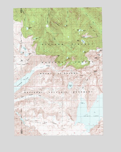
Spirit Lake West, WA USGS Topographic Map
Click on map above to begin viewing in our Map Viewer.

This topographic map contains these locations and features:
Feature Name Type Latitude Longitude GNIS ID View Map
Bear CoveBayN46.2804°W122.1540°1528461View Map
Bear Cove Campground (historical)LocaleN46.2821°W122.1539°2702239View Map
Bear CreekStreamN46.2860°W122.1548°1516229View Map
Black MountainSummitN46.3584°W122.1864°1516613View Map
Black Prince Mine (historical)MineN46.3573°W122.1315°1516625View Map
Coes Dam (historical)DamN46.2665°W122.1612°1532738View Map
Coldwater LakeLakeN46.3027°W122.2407°1528452View Map
Coldwater LookoutTowerN46.3004°W122.1822°1517941View Map
Coldwater PeakSummitN46.3001°W122.1817°1528453View Map
Coldwater TrailTrailN46.2979°W122.2198°1517942View Map
Deer LakeLakeN46.3573°W122.1782°1518631View Map
Duck BayBayN46.2623°W122.1429°1528462View Map
Duck Bay Boating Site (historical)LocaleN46.2653°W122.1328°2702240View Map
Elk LakeLakeN46.3352°W122.2359°1519280View Map
Elk PrairieFlatN46.3237°W122.2423°1519291View Map
Forest LakeLakeN46.3313°W122.2402°1531296View Map
Hanaford LakeLakeN46.3289°W122.2334°1520491View Map
Harmony Falls Landing (historical)Populated PlaceN46.2657°W122.1429°1520555View Map
Harrys RidgeRidgeN46.2753°W122.1740°1528437View Map
Heart LakeLakeN46.3254°W122.1762°1520649View Map
Holmstedt LakeLakeN46.3280°W122.1287°1520872View Map
Island LakeLakeN46.3526°W122.1580°1531467View Map
Johnston RidgeRidgeN46.2767°W122.2150°1528455View Map
Johnston Ridge ObservatoryBuildingN46.2757°W122.2172°2680116View Map
Lang MineMineN46.2957°W122.1354°1521888View Map
Langes CrestAreaN46.2623°W122.1790°1528450View Map
Lonesome LakeLakeN46.3448°W122.2215°1522382View Map
Lower Venus LakeLakeN46.3459°W122.1489°1528946View Map
Minnie Lee Mine (historical)MineN46.3718°W122.1504°1523247View Map
Minnie PeakSummitN46.3277°W122.1897°1523251View Map
Mount MargaretSummitN46.3121°W122.1348°1522728View Map
Mount VenusSummitN46.3424°W122.1619°1527698View Map
Mount WhittierSummitN46.3251°W122.1332°1528112View Map
O'Conner LakeLakeN46.3521°W122.1543°1507124View Map
Saint Helens LakeLakeN46.2987°W122.1721°1525357View Map
Saint Helens Lodge (historical)LocaleN46.2659°W122.1593°1525358View Map
Shovel LakeLakeN46.3333°W122.1317°1525713View Map
Snow LakeLakeN46.3316°W122.1529°1526033View Map
Spirit LakeLakeN46.2728°W122.1404°1526377View Map
Spirit Lake Forest Camp (historical)LocaleN46.2662°W122.1576°1526378View Map
Spirit Lake Lodge (historical)BuildingN46.2643°W122.1804°1526379View Map
Spirit Lake Post Office (historical)Post OfficeN46.2643°W122.1804°2027191View Map
Spirit Lake Ranger Station (historical)BuildingN46.2646°W122.1440°1526380View Map
The DomeSummitN46.3079°W122.1576°1527033View Map
The SpilloverAreaN46.2748°W122.1790°1528445View Map
Tradedollar LakeLakeN46.3548°W122.2318°1527340View Map
Venus LakeLakeN46.3416°W122.1532°1527696View Map
Windy RidgeRidgeN46.2501°W122.1373°1529152View Map
Windy Ridge ViewpointLocaleN46.2501°W122.1373°1529597View Map

Note: Coordinates in the location and feature list above are referenced to NAD83 datum.


Copyright (C) 2008-2024 Ryan Niemi / Sunset Dynamics ... All Rights Reserved