TopoQuest Logo
Do you find TopoQuest useful?
Help keep TopoQuest running and adding new maps/features by donating!
Bitcoin:  19c7KJd3qBynnjoSw5npx9KScwjBe4ifkT
Litecoin:  LXs6TkuXGGXo1vDsWCkWVdjQX94eUKd6ui
Home View Maps Find Maps Find Places Resources & Links


Smackover NE, Arkansas Topographic Map

USGS Map Title: Smackover NE, AR
USGS Map MRC: 33092D5
DRG (GeoTIFF) Download: o33092d5.tif


Neighboring USGS Topographic Map Quads:


  East Camden, AR  
33092E6
 

  Woodberry, AR  
33092E5
 

  Hampton, AR  
33092E4
 

  Snow Hill, AR  
33092D6
 

  Smackover NE, AR  
33092D5
 

  Artesian, AR  
33092D4
 

  Smackover, AR  
33092C6
 

  Calion, AR  
33092C5
 

  Harrell Brake, AR  
33092C4


Map MRC Location:

N34°
W93°
N34°
W92°
H8 H7 H6 H5 H4 H3 H2 H1
G8 G7 G6 G5 G4 G3 G2 G1
F8 F7 F6 F5 F4 F3 F2 F1
E8 E7 E6 E5 E4 E3 E2 E1
D8 D7 D6 D5 D4 D3 D2 D1
C8 C7 C6 C5 C4 C3 C2 C1
B8 B7 B6 B5 B4 B3 B2 B1
A8 A7 A6 A5 A4 A3 A2 A1
N33°
W93°
N33°
W92°

Smackover NE, AR USGS 1:24K Topographic Map Preview:
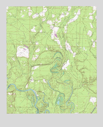
Smackover NE, AR USGS Topographic Map
Click on map above to begin viewing in our Map Viewer.

This topographic map contains these locations and features:
Feature Name Type Latitude Longitude GNIS ID View Map
Big Horseshoe BrakeLakeN33.4229°W92.5585°75643View Map
Black LakeLakeN33.4402°W92.5528°75651View Map
Black Lake SloughLakeN33.4306°W92.5572°75652View Map
Boones MoundSummitN33.3796°W92.5710°75303View Map
China Grove ChurchChurchN33.4696°W92.5704°47749View Map
Cooks LakeLakeN33.4270°W92.5487°75681View Map
Crane LakeLakeN33.3866°W92.5767°75685View Map
Dry BranchStreamN33.4110°W92.5213°48622View Map
Duck Roost LakeLakeN33.3774°W92.5743°75700View Map
Hades LakeLakeN33.3926°W92.5802°75728View Map
Haidee ShoalsBarN33.3915°W92.5829°75307View Map
Hampton Oil FieldOilfieldN33.4493°W92.5193°49813View Map
Haynes BendBendN33.3862°W92.5399°49961View Map
Hollingsworth BrakeLakeN33.3979°W92.5503°75735View Map
Jim Dunn CreekStreamN33.4298°W92.5893°77378View Map
King SloughGutN33.4318°W92.5763°50859View Map
Little Bay CemeteryCemeteryN33.4351°W92.6193°51184View Map
Little Champagnolle CreekStreamN33.4029°W92.5338°51222View Map
Little Horseshoe BrakeLakeN33.3792°W92.5477°75763View Map
Long LakeLakeN33.3891°W92.5562°75768View Map
Long Lake SloughGutN33.3910°W92.5552°51437View Map
Mayner BranchStreamN33.4229°W92.5918°51763View Map
Moses Chapel CemeteryCemeteryN33.4907°W92.5499°52235View Map
Pickett CemeteryCemeteryN33.4587°W92.5029°53345View Map
Primm CemeteryCemeteryN33.4909°W92.5815°53803View Map
Saint Paul CemeteryCemeteryN33.4671°W92.5701°54432View Map
Saint Paul ChurchChurchN33.4698°W92.5757°54439View Map
Slim Island ShoalBarN33.3785°W92.5715°75312View Map
Snow LakeLakeN33.3879°W92.5711°75852View Map
Tom Cook BrakeLakeN33.4466°W92.5539°75868View Map
Township of Champagnolle (historical)CivilN33.4793°W92.6043°63698View Map
Viney BrakeLakeN33.3894°W92.5531°75876View Map

Note: Coordinates in the location and feature list above are referenced to NAD83 datum.


Copyright (C) 2008-2024 Ryan Niemi / Sunset Dynamics ... All Rights Reserved