TopoQuest Logo
Do you find TopoQuest useful?
Help keep TopoQuest running and adding new maps/features by donating!
Bitcoin:  19c7KJd3qBynnjoSw5npx9KScwjBe4ifkT
Litecoin:  LXs6TkuXGGXo1vDsWCkWVdjQX94eUKd6ui
Home View Maps Find Maps Find Places Resources & Links


Silver Lake, New Hampshire Topographic Map

USGS Map Title: Silver Lake, NH
USGS Map MRC: 43071H2
DRG (GeoTIFF) Download: o43071h2.tif


Neighboring USGS Topographic Map Quads:


  Bartlett, NH  
44071A3
 

  North Conway West, NH  
44071A2
 

  North Conway East, NH  
44071A1
 

  Mount Chocorua, NH  
43071H3
 

  Silver Lake, NH  
43071H2
 

  Conway, NH  
43071H1
 

  Tamworth, NH  
43071G3
 

  Ossipee Lake, NH  
43071G2
 

  Freedom, NH  
43071G1


Map MRC Location:

N44°
W72°
N44°
W71°
H8 H7 H6 H5 H4 H3 H2 H1
G8 G7 G6 G5 G4 G3 G2 G1
F8 F7 F6 F5 F4 F3 F2 F1
E8 E7 E6 E5 E4 E3 E2 E1
D8 D7 D6 D5 D4 D3 D2 D1
C8 C7 C6 C5 C4 C3 C2 C1
B8 B7 B6 B5 B4 B3 B2 B1
A8 A7 A6 A5 A4 A3 A2 A1
N43°
W72°
N43°
W71°

Silver Lake, NH USGS 1:24K Topographic Map Preview:
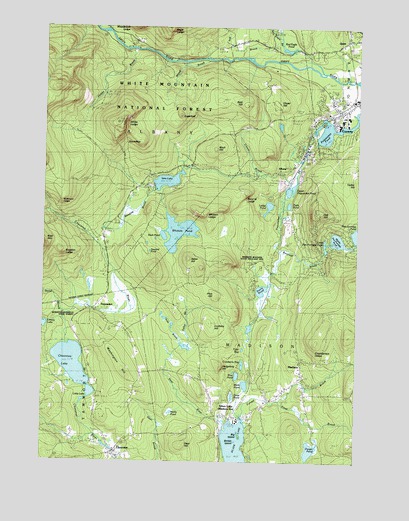
Silver Lake, NH USGS Topographic Map
Click on map above to begin viewing in our Map Viewer.

This topographic map contains these locations and features:
Feature Name Type Latitude Longitude GNIS ID View Map
A Crosby Kennett Middle SchoolSchoolN43.9799°W71.1257°1915864View Map
AlbanyPopulated PlaceN43.9578°W71.1676°871382View Map
Albany ChapelChurchN43.9609°W71.1948°871385View Map
Allard BrookStreamN43.9906°W71.1837°871389View Map
Back PondLakeN43.9403°W71.2028°871421View Map
Bald HillSummitN43.9787°W71.1720°871428View Map
Band M LedgeBenchN43.9520°W71.1687°871442View Map
Banfield BrookStreamN43.9362°W71.1581°871443View Map
Big BrookStreamN43.9973°W71.2248°871500View Map
Big IslandIslandN43.8817°W71.1712°871502View Map
Bimba IslandIslandN43.8812°W71.1737°871506View Map
Birch HillSummitN43.9656°W71.1837°871508View Map
Blackberry Crossing CampgroundLocaleN43.9992°W71.2256°1915884View Map
Blackberry Crossing CampgroundLocaleN43.9959°W71.2248°873087View Map
Blue PondLakeN43.8999°W71.1717°871540View Map
Bowditch-Runnells State ForestParkN43.9156°W71.2342°871561View Map
Bragdon LedgeBenchN43.9353°W71.2420°871573View Map
Carter Ledge TrailTrailN43.9562°W71.2390°871632View Map
Chamberlain LedgeBenchN43.9073°W71.1420°871656View Map
Chase HillSummitN43.9792°W71.1609°871666View Map
ChocoruaPopulated PlaceN43.8790°W71.2198°871674View Map
Chocorua LakeLakeN43.9033°W71.2377°871677View Map
Chocorua Post OfficePost OfficeN43.8785°W71.2204°1915914View Map
Chocorua River DamDamN43.8783°W71.2214°1775784View Map
Chocorua River ReservoirReservoirN43.8784°W71.2162°1775785View Map
Chocorua Village StationBuildingN43.8808°W71.2227°2605283View Map
Clement InnLocaleN43.9392°W71.2245°873081View Map
Conway Post OfficePost OfficeN43.9777°W71.1253°1915923View Map
Conway Village Chamber of CommerceLocaleN43.9787°W71.1267°1915925View Map
Cranberry BogLakeN43.9034°W71.1715°871734View Map
Cream BrookStreamN43.9548°W71.1540°871743View Map
Crothers HillSummitN43.9140°W71.1837°871747View Map
Davis PondLakeN43.9245°W71.1623°871770View Map
Deer HillSummitN43.8798°W71.1948°871777View Map
Deer RiverStreamN43.8842°W71.1773°871778View Map
Drew PondLakeN43.8938°W71.1736°873090View Map
Dry BrookStreamN43.9912°W71.1648°871802View Map
Dugway Forest CampLocaleN43.9926°W71.1812°1915938View Map
Dugway Picnic AreaLocaleN43.9909°W71.1856°1915939View Map
Dugway Picnic AreaLocaleN43.9926°W71.1867°871810View Map
Durgin PondLakeN43.8785°W71.1424°871815View Map
Eagle LedgeBenchN43.9990°W71.2017°871821View Map
Ellen FallsLocaleN43.9812°W71.2267°873088View Map
Forrest BrookStreamN43.8870°W71.1706°871898View Map
Frost BrookStreamN43.8926°W71.1559°871915View Map
Ham BrookStreamN43.9042°W71.1973°871999View Map
Haunted PondLakeN43.9365°W71.2084°872021View Map
Hedgehog HillSummitN43.9017°W71.1795°872030View Map
Hobbs BrookStreamN43.9942°W71.2162°872046View Map
Iona LakeLakeN43.9558°W71.2005°872081View Map
Leavitt AirportAirportN43.9731°W71.1724°873366View Map
Ledge PondLakeN43.9486°W71.1600°872162View Map
Little LakeLakeN43.8945°W71.2306°872190View Map
Little Pea Porridge PondReservoirN43.9387°W71.1330°872192View Map
Little Pea Porridge Pond DamDamN43.9367°W71.1378°1775271View Map
Lonely LakeLakeN43.9142°W71.2489°872207View Map
Lovejoy MarshSwampN43.9484°W71.2167°1916027View Map
Mack PondLakeN43.8971°W71.1684°872237View Map
MadisonPopulated PlaceN43.8992°W71.1484°872242View Map
Madison BoulderPillarN43.9303°W71.1698°872243View Map
Madison Boulder State Geologic SiteLocaleN43.9315°W71.1678°873089View Map
Madison CemeteryCemeteryN43.8876°W71.1431°872244View Map
Madison ChurchChurchN43.9009°W71.1462°1916033View Map
Madison Elementary SchoolSchoolN43.8968°W71.1523°1916034View Map
Madison Fire and Rescue DepartmentBuildingN43.8941°W71.1569°2605282View Map
Madison Police DeptBuildingN43.8948°W71.1566°2752907View Map
Madison Post OfficePost OfficeN43.8930°W71.1575°1916036View Map
Mailly PondLakeN43.8893°W71.1979°872250View Map
Meadow BrookStreamN43.9531°W71.2045°872272View Map
Middle Pea Porridge PondLakeN43.9387°W71.1330°872293View Map
Nickerson LedgeBenchN43.9492°W71.2426°872379View Map
Oak HillSummitN43.9465°W71.1423°872422View Map
PequawketPopulated PlaceN43.9209°W71.2273°872482View Map
Pequawket BrookStreamN43.9701°W71.1426°872483View Map
Pequawket PondReservoirN43.9715°W71.1350°872484View Map
Pine HillSummitN43.9223°W71.1817°872502View Map
Piper TrailTrailN43.9473°W71.2401°872510View Map
QuintPopulated PlaceN43.9973°W71.1326°872535View Map
Red Eagle BrookStreamN43.9876°W71.1426°872551View Map
Red Eagle PondLakeN43.9938°W71.1531°872552View Map
RoundtopSummitN43.9673°W71.2120°872590View Map
Saco Ranger StationLocaleN43.9795°W71.1337°873085View Map
Salter BrookStreamN43.9065°W71.1926°872616View Map
Salter HillSummitN43.9328°W71.1923°872617View Map
Silver LakePopulated PlaceN43.8881°W71.1753°872665View Map
Silver Lake Post OfficePost OfficeN43.8882°W71.1735°1916112View Map
Stoneheart Open Learning Opportunity RescueBuildingN43.9537°W71.1353°2658909View Map
Stony BrookStreamN43.9154°W71.2406°872750View Map
SugarloafSummitN43.9759°W71.1962°872760View Map
Swift BrookStreamN43.9578°W71.1615°873086View Map
Tasker HillSummitN43.9542°W71.1292°872775View Map
Tight PondLakeN43.9490°W71.1519°872817View Map
Town of MadisonCivilN43.8991°W71.1501°873657View Map
Tyler BogLakeN43.9073°W71.1712°872845View Map
Upper Pequawket PondLakeN43.9536°W71.1512°872850View Map
Washington HillRidgeN43.9029°W71.2198°872864View Map
Weetamoo TrailTrailN43.9401°W71.2401°872882View Map
White LedgeBenchN43.9726°W71.2184°872910View Map
White Ledge CampgroundLocaleN43.9548°W71.2140°872911View Map
White Ledge TrailTrailN43.9653°W71.2187°873082View Map
White Mountain Waldorf SchoolSchoolN43.9710°W71.1437°2500263View Map
Whitton LedgeBenchN43.9465°W71.1851°872931View Map
Whitton PondLakeN43.9410°W71.1960°872932View Map
WMWV-FM (Conway)TowerN43.9467°W71.1395°873335View Map
Woodchuck LedgeBenchN43.9987°W71.2145°872966View Map

Note: Coordinates in the location and feature list above are referenced to NAD83 datum.


Copyright (C) 2008-2024 Ryan Niemi / Sunset Dynamics ... All Rights Reserved