TopoQuest Logo
Do you find TopoQuest useful?
Help keep TopoQuest running and adding new maps/features by donating!
Bitcoin:  19c7KJd3qBynnjoSw5npx9KScwjBe4ifkT
Litecoin:  LXs6TkuXGGXo1vDsWCkWVdjQX94eUKd6ui
Home View Maps Find Maps Find Places Resources & Links


Signal Hill, South Dakota Topographic Map

USGS Map Title: Signal Hill, SD
USGS Map MRC: 43103G7
DRG (GeoTIFF) Download: o43103g7.tif


Neighboring USGS Topographic Map Quads:


  Preacher Spring, SD  
43103H8
 

  Ditch Creek, SD  
43103H7
 

  Medicine Mountain, SD  
43103H6
 

  Dead Horse Flats, SD  
43103G8
 

  Signal Hill, SD  
43103G7
 

  Berne, SD  
43103G6
 

  Jewel Cave NW, SD  
43103F8
 

  Jewel Cave, SD  
43103F7
 

  Fourmile, SD  
43103F6


Map MRC Location:

N44°
W104°
N44°
W103°
H8 H7 H6 H5 H4 H3 H2 H1
G8 G7 G6 G5 G4 G3 G2 G1
F8 F7 F6 F5 F4 F3 F2 F1
E8 E7 E6 E5 E4 E3 E2 E1
D8 D7 D6 D5 D4 D3 D2 D1
C8 C7 C6 C5 C4 C3 C2 C1
B8 B7 B6 B5 B4 B3 B2 B1
A8 A7 A6 A5 A4 A3 A2 A1
N43°
W104°
N43°
W103°

Signal Hill, SD USGS 1:24K Topographic Map Preview:
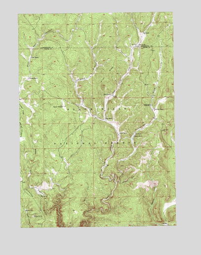
Signal Hill, SD USGS Topographic Map
Click on map above to begin viewing in our Map Viewer.

This topographic map contains these locations and features:
Feature Name Type Latitude Longitude GNIS ID View Map
Alkali SchoolSchoolN43.8205°W103.7705°1261182View Map
Alkali SpringSpringN43.8044°W103.7954°1261183View Map
Bear SpringSpringN43.8556°W103.7785°1261234View Map
Bear Spring CreekStreamN43.7750°W103.7983°1261235View Map
Blacktail SpringSpringN43.7571°W103.8650°1261295View Map
Blacktail WellWellN43.7603°W103.8716°1261296View Map
Bull SpringSpringN43.8037°W103.7840°1261369View Map
Cooper RanchLocaleN43.8372°W103.8671°1261484View Map
Doll RanchLocaleN43.8636°W103.7749°1261567View Map
Elliot RanchLocaleN43.8272°W103.8019°1261638View Map
Elliot RidgeRidgeN43.8389°W103.8049°1261639View Map
Gahl RanchLocaleN43.8133°W103.8063°1261705View Map
Hammock RanchLocaleN43.8183°W103.7674°1261764View Map
Lemming DrawValleyN43.8213°W103.8249°1261944View Map
Lemming WellWellN43.8241°W103.8241°1263044View Map
Limestone HillSummitN43.8193°W103.7604°1263047View Map
Mud SpringSpringN43.7687°W103.8589°1262103View Map
Short ForkStreamN43.7603°W103.8174°1262409View Map
Signal HillSummitN43.8205°W103.8427°1262413View Map
Sourdough DrawValleyN43.7757°W103.7983°1262448View Map
Sturm RanchLocaleN43.8028°W103.7841°1262527View Map
Windmill DrawValleyN43.7759°W103.7959°1262733View Map
Yount RanchLocaleN43.8494°W103.8658°1262754View Map

Note: Coordinates in the location and feature list above are referenced to NAD83 datum.


Copyright (C) 2008-2024 Ryan Niemi / Sunset Dynamics ... All Rights Reserved