TopoQuest Logo
Do you find TopoQuest useful?
Help keep TopoQuest running and adding new maps/features by donating!
Bitcoin:  19c7KJd3qBynnjoSw5npx9KScwjBe4ifkT
Litecoin:  LXs6TkuXGGXo1vDsWCkWVdjQX94eUKd6ui
Home View Maps Find Maps Find Places Resources & Links


Serena, Illinois Topographic Map

USGS Map Title: Serena, IL
USGS Map MRC: 41088D6
DRG (GeoTIFF) Download: o41088d6.tif


Neighboring USGS Topographic Map Quads:


  Leland, IL  
41088E7
 

  Sheridan, IL  
41088E6
 

  Newark, IL  
41088E5
 

  Wedron, IL  
41088D7
 

  Serena, IL  
41088D6
 

  Stavanger, IL  
41088D5
 

  Ottawa, IL  
41088C7
 

  Marseilles, IL  
41088C6
 

  Seneca, IL  
41088C5


Map MRC Location:

N42°
W89°
N42°
W88°
H8 H7 H6 H5 H4 H3 H2 H1
G8 G7 G6 G5 G4 G3 G2 G1
F8 F7 F6 F5 F4 F3 F2 F1
E8 E7 E6 E5 E4 E3 E2 E1
D8 D7 D6 D5 D4 D3 D2 D1
C8 C7 C6 C5 C4 C3 C2 C1
B8 B7 B6 B5 B4 B3 B2 B1
A8 A7 A6 A5 A4 A3 A2 A1
N41°
W89°
N41°
W88°

Serena, IL USGS 1:24K Topographic Map Preview:
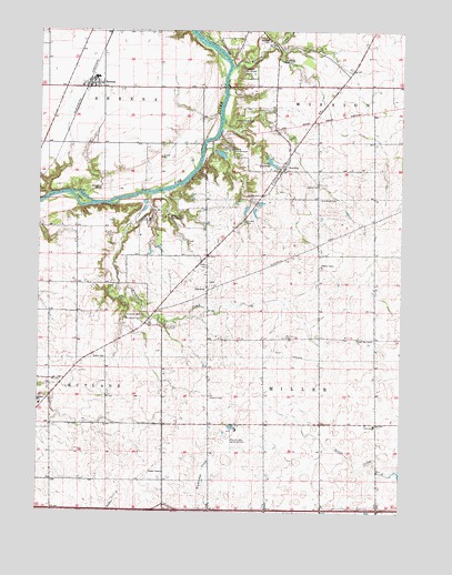
Serena, IL USGS Topographic Map
Click on map above to begin viewing in our Map Viewer.

This topographic map contains these locations and features:
Feature Name Type Latitude Longitude GNIS ID View Map
Armson School (historical)SchoolN41.4856°W88.6315°1748208View Map
Barber School (historical)SchoolN41.3761°W88.6354°1748209View Map
Brumbach CemeteryCemeteryN41.4250°W88.7142°405001View Map
Brumbach CreekStreamN41.4575°W88.7120°405002View Map
Camp CloverleafLocaleN41.4761°W88.6829°405443View Map
Camp MerrybrookLocaleN41.4889°W88.6767°405486View Map
Classon School (historical)SchoolN41.4464°W88.7267°1748214View Map
DanwayPopulated PlaceN41.4325°W88.6917°422605View Map
David Strawn CemeteryCemeteryN41.4347°W88.6912°1957870View Map
Fox River CemeteryCemeteryN41.4565°W88.6535°408639View Map
Fox River Lutheran ChurchChurchN41.4598°W88.6545°414718View Map
Grove School (historical)SchoolN41.3978°W88.6531°1748228View Map
Hall School (historical)SchoolN41.4189°W88.7270°1748229View Map
Indian IslandIslandN41.4559°W88.7348°410866View Map
Interchange 97CrossingN41.3756°W88.7062°1816072View Map
Jim Wehrli Memorial Airport (historical)AirportN41.4482°W88.7160°427522View Map
Lake HermanReservoirN41.4659°W88.6703°410095View Map
Lake Herman DamDamN41.4659°W88.6706°1692611View Map
Lang School (historical)SchoolN41.3981°W88.6956°1748241View Map
Latter Day Saints ChurchChurchN41.4203°W88.6401°1748243View Map
Longview Airport (historical)AirportN41.3878°W88.6701°427521View Map
Lower Fox River - Blakes Landing Nature PreserveParkN41.4579°W88.7433°1994609View Map
Milton Pope Elementary SchoolSchoolN41.3975°W88.6337°416022View Map
Mission CreekStreamN41.4903°W88.6842°413674View Map
Nelson CemeteryCemeteryN41.4574°W88.6739°414350View Map
NorwayPopulated PlaceN41.4656°W88.6645°414716View Map
Norway CemeteryCemeteryN41.4501°W88.6795°414717View Map
Norwegian Settlers State MemorialParkN41.4634°W88.6667°1816099View Map
Olson CemeteryCemeteryN41.4389°W88.6923°415108View Map
Osmundson CemeteryCemeteryN41.4781°W88.6454°1957963View Map
Prairie Lake Hunt Club Airport (historical)AirportN41.3950°W88.6829°427519View Map
Rosedale School (historical)SchoolN41.4423°W88.6542°1748259View Map
Rottner FieldAirportN41.4836°W88.7042°2770396View Map
Rutland Elementary SchoolSchoolN41.4028°W88.7492°417080View Map
Section CemeteryCemeteryN41.4204°W88.6652°418178View Map
Section School (historical)SchoolN41.4200°W88.6587°1748268View Map
SerenaPopulated PlaceN41.4861°W88.7315°418219View Map
Serena Community Fire Protection District Main StationBuildingN41.4848°W88.7311°2682100View Map
Serena Elementary SchoolSchoolN41.4878°W88.7301°1816138View Map
Serena Fire Protection District Norway StationBuildingN41.4687°W88.6701°2682021View Map
Serena High SchoolSchoolN41.4878°W88.7312°1816139View Map
Serena Post OfficePost OfficeN41.4862°W88.7330°1816140View Map
Serena United Methodist ChurchChurchN41.4853°W88.7359°1986433View Map
Sheridan SchoolSchoolN41.4978°W88.6723°418357View Map
Spradling CemeteryCemeteryN41.4920°W88.6667°418916View Map
Township of MillerCivilN41.4127°W88.6510°429366View Map
Township of RutlandCivilN41.3857°W88.7473°429688View Map
Viking CampgroundLocaleN41.4689°W88.6848°420312View Map
Wilderness CampgroundLocaleN41.4514°W88.7065°421160View Map

Note: Coordinates in the location and feature list above are referenced to NAD83 datum.


Copyright (C) 2008-2024 Ryan Niemi / Sunset Dynamics ... All Rights Reserved