TopoQuest Logo
Do you find TopoQuest useful?
Help keep TopoQuest running and adding new maps/features by donating!
Bitcoin:  19c7KJd3qBynnjoSw5npx9KScwjBe4ifkT
Litecoin:  LXs6TkuXGGXo1vDsWCkWVdjQX94eUKd6ui
Home View Maps Find Maps Find Places Resources & Links


Sacramento Peak, New Mexico Topographic Map

USGS Map Title: Sacramento Peak, NM
USGS Map MRC: 32105G7
DRG (GeoTIFF) Download: o32105g7.tif


Neighboring USGS Topographic Map Quads:


  Alamogordo North, NM  
32105H8
 

  High Rolls, NM  
32105H7
 

  Cloudcroft, NM  
32105H6
 

  Alamogordo South, NM  
32105G8
 

  Sacramento Peak, NM  
32105G7
 

  Bluff Springs, NM  
32105G6
 

  Deadman Canyon, NM  
32105F8
 

  Bug Scuffle Canyon, NM  
32105F7
 

  Rogers Ruins, NM  
32105F6


Map MRC Location:

N33°
W106°
N33°
W105°
H8 H7 H6 H5 H4 H3 H2 H1
G8 G7 G6 G5 G4 G3 G2 G1
F8 F7 F6 F5 F4 F3 F2 F1
E8 E7 E6 E5 E4 E3 E2 E1
D8 D7 D6 D5 D4 D3 D2 D1
C8 C7 C6 C5 C4 C3 C2 C1
B8 B7 B6 B5 B4 B3 B2 B1
A8 A7 A6 A5 A4 A3 A2 A1
N32°
W106°
N32°
W105°

Sacramento Peak, NM USGS 1:24K Topographic Map Preview:
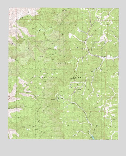
Sacramento Peak, NM USGS Topographic Map
Click on map above to begin viewing in our Map Viewer.

This topographic map contains these locations and features:
Feature Name Type Latitude Longitude GNIS ID View Map
AdyMineN32.8673°W105.8372°916926View Map
Alamo Canyon SpringsSpringN32.8462°W105.8561°902627View Map
Alamo Lookout TowerTowerN32.8729°W105.8119°928856View Map
Alamo PeakSummitN32.8726°W105.8125°920555View Map
Apache Point ObservatoryLocaleN32.7787°W105.8139°936624View Map
Atkinson CanyonValleyN32.8420°W105.7878°903457View Map
Atkinson FieldFlatN32.8484°W105.8055°936621View Map
Ball CanyonValleyN32.8365°W105.7858°903499View Map
Brown CanyonValleyN32.8098°W105.7789°1989349View Map
Cathey CanyonValleyN32.8098°W105.7789°915950View Map
Cathey PeakSummitN32.8076°W105.7997°1988161View Map
Cathey VistaLocaleN32.8073°W105.8000°899297View Map
Cherry CanyonValleyN32.8412°W105.8441°905069View Map
Corral CanyonValleyN32.7684°W105.7847°905362View Map
Deadman CanyonValleyN32.8040°W105.7878°1989348View Map
Dirty Drawers CanyonValleyN32.8584°W105.7816°920445View Map
Fenimore CanyonValleyN32.8506°W105.7855°1989341View Map
Good CanyonValleyN32.8451°W105.8553°1989343View Map
Gordon CanyonValleyN32.8412°W105.8441°1989344View Map
Holder RidgeRidgeN32.7870°W105.8594°912801View Map
Johnson CanyonValleyN32.8473°W105.7839°907401View Map
Joplin RidgeRidgeN32.7695°W105.8666°1988163View Map
Lamalone LodgeLocaleN32.7879°W105.8358°907836View Map
Lawrence CanyonValleyN32.7906°W105.8603°1989350View Map
MarciaPopulated PlaceN32.8287°W105.7678°908408View Map
Marcia CemeteryCemeteryN32.8284°W105.7550°1988160View Map
Marcia Post Office (historical)Post OfficeN32.8287°W105.7678°938224View Map
McAfee CanyonValleyN32.7654°W105.7830°908487View Map
Moore CanyonValleyN32.7559°W105.7822°908886View Map
Mountain LaboratoryLocaleN32.7959°W105.7966°936623View Map
Peņasco CanyonValleyN32.8306°W105.7811°909549View Map
Potato KnobSummitN32.8284°W105.8372°1988159View Map
Rice CanyonValleyN32.8306°W105.7833°910157View Map
Road CanyonValleyN32.7693°W105.8364°1989351View Map
Sacramento LakeLakeN32.7518°W105.7787°1988165View Map
Sacramento PeakSummitN32.7879°W105.8208°910505View Map
Schofield CanyonValleyN32.8306°W105.7811°1989345View Map
Short RidgeRidgeN32.7590°W105.8422°1988164View Map
Stark PeakSummitN32.8548°W105.8464°1988158View Map
SunspotLocaleN32.7898°W105.8208°936625View Map
Sunspot Post Office (historical)Post OfficeN32.7898°W105.8208°937274View Map
Sunspot Volunteer Fire DepartmentBuildingN32.7908°W105.8160°2657871View Map
Taylor CanyonValleyN32.8287°W105.7678°1989346View Map
Telephone CanyonValleyN32.8190°W105.7716°1989347View Map
Thousandmile CanyonValleyN32.7540°W105.7791°911674View Map
Water CanyonValleyN32.8270°W105.7661°912167View Map
Well Number OneWellN32.7856°W105.8000°922681View Map
Well Number TwoWellN32.7845°W105.8025°1988162View Map

Note: Coordinates in the location and feature list above are referenced to NAD83 datum.


Copyright (C) 2008-2024 Ryan Niemi / Sunset Dynamics ... All Rights Reserved