TopoQuest Logo
Do you find TopoQuest useful?
Help keep TopoQuest running and adding new maps/features by donating!
Bitcoin:  19c7KJd3qBynnjoSw5npx9KScwjBe4ifkT
Litecoin:  LXs6TkuXGGXo1vDsWCkWVdjQX94eUKd6ui
Home View Maps Find Maps Find Places Resources & Links


Sabinal, Texas Topographic Map

USGS Map Title: Sabinal, TX
USGS Map MRC: 29099C4
DRG (GeoTIFF) Download: o29099c4.tif


Neighboring USGS Topographic Map Quads:


  Trio, TX  
29099D5
 

  Comanche Waterhole, TX  
29099D4
 

  Sabinal NE, TX  
29099D3
 

  Blanco Lake, TX  
29099C5
 

  Sabinal, TX  
29099C4
 

  D'Hanis, TX  
29099C3
 

  Garner Field NE, TX  
29099B5
 

  Irishman Hill, TX  
29099B4
 

  Frio Town NE, TX  
29099B3


Map MRC Location:

N30°
W100°
N30°
W99°
H8 H7 H6 H5 H4 H3 H2 H1
G8 G7 G6 G5 G4 G3 G2 G1
F8 F7 F6 F5 F4 F3 F2 F1
E8 E7 E6 E5 E4 E3 E2 E1
D8 D7 D6 D5 D4 D3 D2 D1
C8 C7 C6 C5 C4 C3 C2 C1
B8 B7 B6 B5 B4 B3 B2 B1
A8 A7 A6 A5 A4 A3 A2 A1
N29°
W100°
N29°
W99°

Sabinal, TX USGS 1:24K Topographic Map Preview:
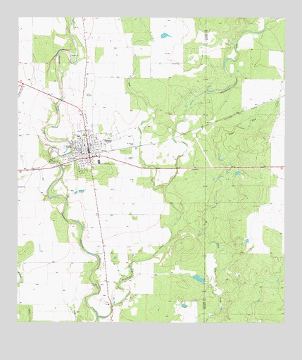
Sabinal, TX USGS Topographic Map
Click on map above to begin viewing in our Map Viewer.

This topographic map contains these locations and features:
Feature Name Type Latitude Longitude GNIS ID View Map
Bader LakeReservoirN29.3402°W99.3887°1863211View Map
Bader Lake DamDamN29.3402°W99.3887°1863210View Map
City of SabinalCivilN29.3213°W99.4695°2411018View Map
Davenport CemeteryCemeteryN29.3355°W99.4275°1355667View Map
Elm CreekStreamN29.3058°W99.4309°1373634View Map
Nelson LakeReservoirN29.2669°W99.4120°1862449View Map
Nelson Lake DamDamN29.2669°W99.4120°1862448View Map
Rancheros CreekStreamN29.2522°W99.4623°1375626View Map
SabinalPopulated PlaceN29.3175°W99.4664°1367078View Map
Sabinal CemeteryCemeteryN29.3172°W99.4495°1367080View Map
Sabinal City HallBuildingN29.3217°W99.4675°2753778View Map
Sabinal City ParkParkN29.3275°W99.4695°2029430View Map
Sabinal Emergency Medical ServiceBuildingN29.3218°W99.4677°2656178View Map
Sabinal Police DepartmentBuildingN29.3217°W99.4675°2750392View Map
Sabinal Post OfficePost OfficeN29.3197°W99.4678°2731828View Map
Sabinal Volunteer Fire DepartmentBuildingN29.3163°W99.4762°2551911View Map
Saint Patrick CemeteryCemeteryN29.3225°W99.4459°1367283View Map

Note: Coordinates in the location and feature list above are referenced to NAD83 datum.


Copyright (C) 2008-2024 Ryan Niemi / Sunset Dynamics ... All Rights Reserved