TopoQuest Logo
Do you find TopoQuest useful?
Help keep TopoQuest running and adding new maps/features by donating!
Bitcoin:  19c7KJd3qBynnjoSw5npx9KScwjBe4ifkT
Litecoin:  LXs6TkuXGGXo1vDsWCkWVdjQX94eUKd6ui
Home View Maps Find Maps Find Places Resources & Links


Rosedale, Mississippi Topographic Map

USGS Map Title: Rosedale, MS
USGS Map MRC: 33091G1
DRG (GeoTIFF) Download: o33091g1.tif


Neighboring USGS Topographic Map Quads:


  Yancopin, AR  
33091H2
 

  Montgomery Island, AR  
33091H1
 

  Gunnison, MS  
33090H8
 

  Lake Cheatham, AR  
33091G2
 

  Rosedale, MS  
33091G1
 

  Beulah, MS  
33090G8
 

  Catfish Point, MS  
33091F2
 

  Benoit, MS  
33091F1
 

  Lobdell, MS  
33090F8


Map MRC Location:

N34°
W92°
N34°
W91°
H8 H7 H6 H5 H4 H3 H2 H1
G8 G7 G6 G5 G4 G3 G2 G1
F8 F7 F6 F5 F4 F3 F2 F1
E8 E7 E6 E5 E4 E3 E2 E1
D8 D7 D6 D5 D4 D3 D2 D1
C8 C7 C6 C5 C4 C3 C2 C1
B8 B7 B6 B5 B4 B3 B2 B1
A8 A7 A6 A5 A4 A3 A2 A1
N33°
W92°
N33°
W91°

Rosedale, MS USGS 1:24K Topographic Map Preview:
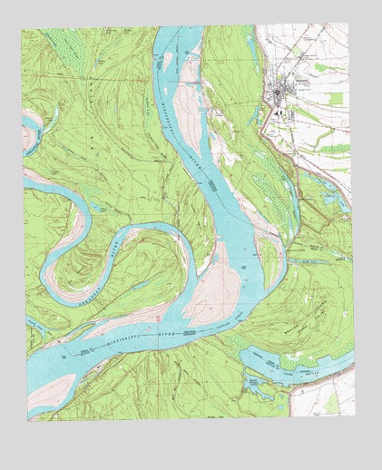
Rosedale, MS USGS Topographic Map
Click on map above to begin viewing in our Map Viewer.

This topographic map contains these locations and features:
Feature Name Type Latitude Longitude GNIS ID View Map
Anns Tabernacle CemeteryCemeteryN33.8343°W91.0209°666279View Map
Arkansas RiverStreamN33.7751°W91.0709°78956View Map
Beulah CrevasseLakeN33.7604°W91.0382°667052View Map
Beulah Island LandingPopulated PlaceN33.8026°W91.0254°57370View Map
Beulah Island Number 74IslandN33.7832°W91.0104°81973View Map
Billy Moore LakeLakeN33.8728°W91.1152°75649View Map
Bolivar County High SchoolSchoolN33.8568°W91.0265°710115View Map
Bolivar County Junior High SchoolSchoolN33.8465°W91.0265°710117View Map
Bolivar County Sheriff's OfficeBuildingN33.8537°W91.0271°2754291View Map
Cat IslandCapeN33.7962°W91.1059°47522View Map
Chute of Island Number 73IslandN33.8054°W91.0668°82005View Map
City of RosedaleCivilN33.8526°W91.0339°2404649View Map
Clark CemeteryCemeteryN33.7501°W91.0143°668510View Map
Cumbyville BarBarN33.8640°W91.0693°687972View Map
Hog Pen SloughGutN33.7593°W91.0682°671264View Map
Island Number 73CapeN33.8137°W91.0598°82462View Map
Jimmie LakeSwampN33.8299°W91.1162°50654View Map
Joe Barnes Vocational Technical CenterSchoolN33.8465°W91.0279°710128View Map
Klondike LandingLocaleN33.8468°W91.0626°1700672View Map
Knowlton BayouGutN33.8326°W91.0807°50903View Map
Knowlton PointCapeN33.8576°W91.0532°687991View Map
Lake BeulahLakeN33.7635°W91.0161°75642View Map
Legion LakeLakeN33.8173°W91.0034°672395View Map
Log Loader ChuteLakeN33.8191°W91.0221°672767View Map
Long LakeSwampN33.8351°W91.1057°51434View Map
Long LakeLakeN33.7994°W91.0174°75769View Map
Lower Rosedale LandingLocaleN33.8634°W91.0321°710130View Map
McCloud LandingLocaleN33.7923°W91.0684°63763View Map
Napoleon CutoffChannelN33.7809°W91.0462°52572View Map
Napoleon LandingLocaleN33.7968°W91.0740°63764View Map
O'Neal LandingLocaleN33.8084°W91.0723°63765View Map
Ozark LandingLocaleN33.7751°W91.1029°63766View Map
Pelican LakeLakeN33.8444°W91.1141°75820View Map
Pleasant Green ChurchChurchN33.8640°W91.0173°675975View Map
Pleasant Grove CemeteryCemeteryN33.8645°W91.0173°688082View Map
Prentiss BarBarN33.7662°W91.0993°676321View Map
Prentiss LandingLocaleN33.7737°W91.0640°688084View Map
Prices BayouGutN33.8176°W91.0904°53796View Map
Prices LakeLakeN33.8180°W91.0978°75828View Map
Riverton LandingPopulated PlaceN33.8198°W91.0209°692179View Map
Riverton RevetmentLeveeN33.8237°W91.0221°688086View Map
RosedalePopulated PlaceN33.8534°W91.0279°676870View Map
Rosedale BendBendN33.8626°W91.0662°710139View Map
Rosedale BendBendN33.8043°W91.0284°63767View Map
Rosedale LandingLocaleN33.8507°W91.0334°710140View Map
Rosedale Police DepartmentBuildingN33.8535°W91.0287°2754238View Map
Rosedale Post OfficePost OfficeN33.8546°W91.0291°2768777View Map
Rosedale Sewage Lagoon DamDamN33.8518°W91.0101°682370View Map
Rosedale Volunteer Fire DepartmentBuildingN33.8524°W91.0278°2665671View Map
Sanders LakeSwampN33.8488°W91.0771°54558View Map
Sanders Lake BayouGutN33.8357°W91.0740°54559View Map
Sawgrass Lake (historical)LakeN33.8409°W91.0073°688092View Map
Swan Deer BrakeSwampN33.8698°W91.1068°55365View Map
Swan Deer LakeSwampN33.8736°W91.1089°55366View Map
Timber LakeLakeN33.8643°W91.0959°75867View Map
Walter Sillers Memorial ParkParkN33.8409°W91.0293°710151View Map
Whiskey ChuteChannelN33.8029°W91.1001°63768View Map

Note: Coordinates in the location and feature list above are referenced to NAD83 datum.


Copyright (C) 2008-2024 Ryan Niemi / Sunset Dynamics ... All Rights Reserved