TopoQuest Logo
Do you find TopoQuest useful?
Help keep TopoQuest running and adding new maps/features by donating!
Bitcoin:  19c7KJd3qBynnjoSw5npx9KScwjBe4ifkT
Litecoin:  LXs6TkuXGGXo1vDsWCkWVdjQX94eUKd6ui
Home View Maps Find Maps Find Places Resources & Links


Rito Alto Peak, Colorado Topographic Map

USGS Map Title: Rito Alto Peak, CO
USGS Map MRC: 38105A6
DRG (GeoTIFF) Download: o38105a6.tif


Neighboring USGS Topographic Map Quads:


  Valley View Hot Springs, CO  
38105B7
 

  Electric Peak, CO  
38105B6
 

  Beckwith Mountain, CO  
38105B5
 

  Mirage, CO  
38105A7
 

  Rito Alto Peak, CO  
38105A6
 

  Horn Peak, CO  
38105A5
 

  Sheds Camp, CO  
37105H7
 

  Crestone, CO  
37105H6
 

  Crestone Peak, CO  
37105H5


Map MRC Location:

N39°
W106°
N39°
W105°
H8 H7 H6 H5 H4 H3 H2 H1
G8 G7 G6 G5 G4 G3 G2 G1
F8 F7 F6 F5 F4 F3 F2 F1
E8 E7 E6 E5 E4 E3 E2 E1
D8 D7 D6 D5 D4 D3 D2 D1
C8 C7 C6 C5 C4 C3 C2 C1
B8 B7 B6 B5 B4 B3 B2 B1
A8 A7 A6 A5 A4 A3 A2 A1
N38°
W106°
N38°
W105°

Rito Alto Peak, CO USGS 1:24K Topographic Map Preview:
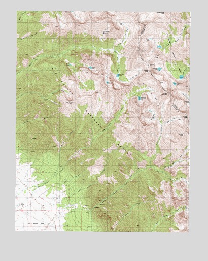
Rito Alto Peak, CO USGS Topographic Map
Click on map above to begin viewing in our Map Viewer.

This topographic map contains these locations and features:
Feature Name Type Latitude Longitude GNIS ID View Map
Blind LakeLakeN38.0946°W105.7116°191931View Map
Dimick GulchValleyN38.0163°W105.7205°191956View Map
Dry GulchValleyN38.0200°W105.7205°191957View Map
Elaine LakeLakeN38.0930°W105.6968°2712781View Map
Eureka LakeLakeN38.0842°W105.6364°191942View Map
Eureka MountainSummitN38.0792°W105.6403°191949View Map
Gibson PeakSummitN38.0731°W105.7122°191944View Map
Groundhog BasinBasinN38.0653°W105.6520°191950View Map
Hermit LakeLakeN38.0880°W105.6317°191938View Map
Hermit Lake TrailTrailN38.0961°W105.6589°191941View Map
Hermit PassGapN38.0961°W105.6553°191935View Map
Hermit PeakSummitN38.0913°W105.6551°191934View Map
Horseshoe LakeLakeN38.0926°W105.6473°191936View Map
Hutchinson HomesteadLocaleN38.0122°W105.7220°197150View Map
Hutchinson HomesteadLocaleN38.0117°W105.7206°191946View Map
King HomesteadLocaleN38.0206°W105.7475°191945View Map
Kolkman BasinBasinN38.1097°W105.6889°191930View Map
Lake Fork North Crestone CreekStreamN38.0344°W105.6456°192265View Map
Loop TrailTrailN38.0389°W105.6367°203560View Map
Mas Alto LakeLakeN38.0847°W105.6848°2722848View Map
Middle Fork North Crestone CreekStreamN38.0344°W105.6456°192264View Map
Mill CreekStreamN38.0342°W105.7214°191955View Map
North Crestone CampgroundLocaleN38.0250°W105.6756°191947View Map
North Fork Cedar CreekStreamN38.0772°W105.7492°191928View Map
North Fork North Creston CreekStreamN38.0369°W105.6533°191953View Map
Rito Alto LakeLakeN38.0886°W105.6772°191932View Map
Rito Alto PeakSummitN38.1028°W105.6617°191933View Map
Rito Alto TrailTrailN38.0833°W105.6617°191943View Map
San Isabel LakeLakeN38.0758°W105.6616°191948View Map
Sangre de Cristo WildernessReserveN38.0310°W105.6459°2035586View Map
South Fork Cedar CreekStreamN38.0772°W105.7492°191929View Map
Stinking ArroyoStreamN38.1097°W105.7108°193836View Map
Venable PassGapN38.0656°W105.6256°191951View Map
Venable PeakSummitN38.0551°W105.6296°191952View Map

Note: Coordinates in the location and feature list above are referenced to NAD83 datum.


Copyright (C) 2008-2024 Ryan Niemi / Sunset Dynamics ... All Rights Reserved