TopoQuest Logo
Do you find TopoQuest useful?
Help keep TopoQuest running and adding new maps/features by donating!
Bitcoin:  19c7KJd3qBynnjoSw5npx9KScwjBe4ifkT
Litecoin:  LXs6TkuXGGXo1vDsWCkWVdjQX94eUKd6ui
Home View Maps Find Maps Find Places Resources & Links


Riegelsville, Pennsylvania Topographic Map

USGS Map Title: Riegelsville, PA
USGS Map MRC: 40075E2
DRG (GeoTIFF) Download: o40075e2.tif


Neighboring USGS Topographic Map Quads:


  Nazareth, PA  
40075F3
 

  Easton, PA  
40075F2
 

  Bloomsbury, NJ  
40075F1
 

  Hellertown, PA  
40075E3
 

  Riegelsville, PA  
40075E2
 

  Frenchtown, NJ  
40075E1
 

  Quakertown, PA  
40075D3
 

  Bedminster, PA  
40075D2
 

  Lumberville, PA  
40075D1


Map MRC Location:

N41°
W76°
N41°
W75°
H8 H7 H6 H5 H4 H3 H2 H1
G8 G7 G6 G5 G4 G3 G2 G1
F8 F7 F6 F5 F4 F3 F2 F1
E8 E7 E6 E5 E4 E3 E2 E1
D8 D7 D6 D5 D4 D3 D2 D1
C8 C7 C6 C5 C4 C3 C2 C1
B8 B7 B6 B5 B4 B3 B2 B1
A8 A7 A6 A5 A4 A3 A2 A1
N40°
W76°
N40°
W75°

Riegelsville, PA USGS 1:24K Topographic Map Preview:
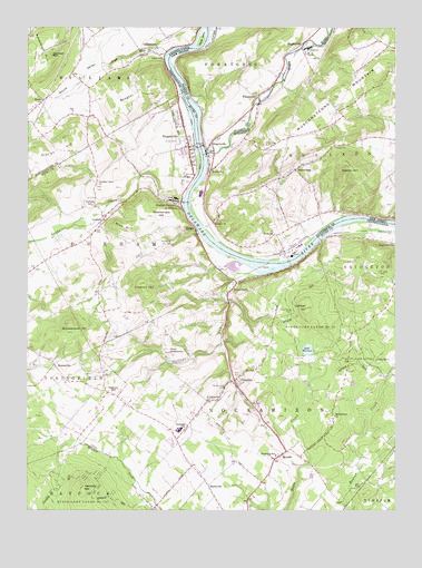
Riegelsville, PA USGS Topographic Map
Click on map above to begin viewing in our Map Viewer.

This topographic map contains these locations and features:
Feature Name Type Latitude Longitude GNIS ID View Map
AmsterdamPopulated PlaceN40.5876°W75.1585°874335View Map
Borough of RiegelsvilleCivilN40.5963°W75.1987°1214978View Map
Bougher HillSummitN40.6079°W75.2118°1170030View Map
Bougher Hill SchoolSchoolN40.6087°W75.2121°1196185View Map
BucksvillePopulated PlaceN40.5065°W75.1877°1203183View Map
Bucksville ManorPopulated PlaceN40.5120°W75.1891°1196195View Map
Bucksville Post Office (historical)Post OfficeN40.5065°W75.1877°1214514View Map
Buckwampum HillSummitN40.5462°W75.2357°1170588View Map
BursonvillePopulated PlaceN40.5379°W75.2402°1170757View Map
Bursonville Post Office (historical)Post OfficeN40.5379°W75.2402°1214577View Map
Camp DavisLocaleN40.5393°W75.1305°1171000View Map
Camp NockamixonLocaleN40.5409°W75.2013°1171063View Map
Chestnut HillSummitN40.5587°W75.2107°1171723View Map
CoffeetownPopulated PlaceN40.6190°W75.2077°1172133View Map
Coffman HillSummitN40.5526°W75.1543°1172135View Map
Cooks CreekStreamN40.5801°W75.1966°1172390View Map
DurhamPopulated PlaceN40.5757°W75.2232°1173637View Map
Durham CemeteryCemeteryN40.5838°W75.2257°2776551View Map
Durham Ferry (historical)LocaleN40.5790°W75.1952°1196189View Map
Durham FurnacePopulated PlaceN40.5795°W75.1971°1173638View Map
Durham Hill FarmsPopulated PlaceN40.5632°W75.2285°1196190View Map
Durham Paper Company DamDamN40.5804°W75.1991°1196187View Map
Durham Post OfficePost OfficeN40.5764°W75.2239°2777389View Map
Durham Post Office (historical)Post OfficeN40.5757°W75.2232°1214571View Map
Durham Union ChurchChurchN40.5845°W75.2257°1173641View Map
Durham Union SchoolSchoolN40.5793°W75.2274°1173642View Map
Durham-Nockamixon Elementary SchoolSchoolN40.5223°W75.2007°1210916View Map
Falls CreekStreamN40.5548°W75.1421°1202458View Map
FerndalePopulated PlaceN40.5337°W75.1788°1174701View Map
Ferndale Post OfficePost OfficeN40.5320°W75.1783°2777395View Map
Ferndale Post Office (historical)Post OfficeN40.5337°W75.1788°1214575View Map
FinesvillePopulated PlaceN40.6084°W75.1710°876338View Map
Finesville Census Designated PlaceCensusN40.6112°W75.1706°2583989View Map
Finesville DamDamN40.6054°W75.1710°884255View Map
Frys RunStreamN40.6184°W75.2016°1175311View Map
Gallows HillPopulated PlaceN40.5307°W75.2218°1175397View Map
Gallows Hill GraveyardCemeteryN40.5362°W75.2239°2776561View Map
Gallows RunStreamN40.5609°W75.1710°1175398View Map
Gravel HillSummitN40.5879°W75.1391°876723View Map
Haupts Mill BridgeBridgeN40.5695°W75.2496°1176651View Map
Haycock Brigade Field (historical)AirportN40.5209°W75.2363°1194011View Map
Haycock CreekStreamN40.5001°W75.2038°1209301View Map
Hexenkopf HillSummitN40.6212°W75.2430°1176929View Map
Hexenkopf RockPillarN40.6179°W75.2413°1176930View Map
HollandPopulated PlaceN40.5720°W75.1655°877169View Map
Holland ChurchChurchN40.5759°W75.1860°877173View Map
Holland Township Police DepartmentBuildingN40.5960°W75.1273°2730965View Map
Holland Township Volunteer Fire Company Station 2BuildingN40.5904°W75.1873°2614092View Map
Hollow RunStreamN40.5743°W75.2282°1196191View Map
HughesvillePopulated PlaceN40.6220°W75.1557°877282View Map
KintnersvillePopulated PlaceN40.5570°W75.1796°1178531View Map
Kintnersville Post OfficePost OfficeN40.5579°W75.1798°2777452View Map
Lake WarrenReservoirN40.5418°W75.1543°1190599View Map
Lake Warren DamDamN40.5401°W75.1530°1194889View Map
Lone Cottage SchoolSchoolN40.5301°W75.1355°1196197View Map
Lynn IslandIslandN40.5626°W75.1693°1180124View Map
Mine HillSummitN40.5723°W75.2149°1181307View Map
MonroePopulated PlaceN40.5729°W75.1921°1204199View Map
Mount JoyPopulated PlaceN40.5870°W75.1868°878551View Map
Musconetcong RiverStreamN40.5923°W75.1888°878667View Map
NarrowsvillePopulated PlaceN40.5701°W75.1288°1204256View Map
Nockamixon CemeteryCemeteryN40.5314°W75.1820°1182493View Map
Nockamixon CliffsCliffN40.5618°W75.1613°1207021View Map
Palisades Junior-Senior High SchoolSchoolN40.5209°W75.1971°1210711View Map
Pleasant ValleyValleyN40.5801°W75.1966°1196188View Map
Pohatcong CreekStreamN40.6224°W75.1882°879385View Map
Rattlesnake HillSummitN40.5768°W75.2063°1184672View Map
Raubs IslandIslandN40.6220°W75.1899°1184696View Map
ReverePopulated PlaceN40.5154°W75.1610°1184953View Map
Revere Post OfficePost OfficeN40.5145°W75.1618°2777453View Map
Revere Post Office (historical)Post OfficeN40.5154°W75.1610°1214587View Map
Rick's Egg FarmLocaleN40.5281°W75.2147°2725565View Map
RiegelsvillePopulated PlaceN40.5945°W75.1871°879691View Map
RiegelsvillePopulated PlaceN40.5943°W75.1955°1185056View Map
Riegelsville Community Fire Company Station 42BuildingN40.5940°W75.1971°2652710View Map
Riegelsville Post OfficePost OfficeN40.5943°W75.1935°2777426View Map
Riegelsville Post Office (historical)Post OfficeN40.5943°W75.1943°1214585View Map
Ringing RockAreaN40.5618°W75.1296°1185093View Map
Ringing Rocks County ParkParkN40.5615°W75.1266°1196199View Map
Rodges RunStreamN40.5734°W75.1922°1212006View Map
Rolling Hill AcresPopulated PlaceN40.5273°W75.1696°1196196View Map
Saint Johns United Church of ChristChurchN40.5943°W75.1960°1200571View Map
Saint Josephs ChurchChurchN40.5245°W75.1446°1217360View Map
Saint Lukes ChurchChurchN40.5290°W75.1835°1186295View Map
Saint Lukes Evangelical Lutheran Church CemeteryCemeteryN40.5292°W75.1834°2776658View Map
Seips SchoolSchoolN40.5220°W75.2021°1196193View Map
State Game Lands Number 56ParkN40.5493°W75.1502°1188517View Map
Steelys HillSummitN40.5932°W75.2393°1188591View Map
Stony Point SchoolSchoolN40.5332°W75.2299°1196192View Map
StoutsPopulated PlaceN40.6062°W75.2443°1188822View Map
Stouts SchoolSchoolN40.6001°W75.2399°1196186View Map
Stouts ValleyValleyN40.6184°W75.2029°1188824View Map
Township of DurhamCivilN40.5713°W75.2175°1216015View Map
Township of NockamixonCivilN40.5224°W75.1727°1216026View Map
Trauger SchoolSchoolN40.5368°W75.2007°1196194View Map
Union / Riegelsville Union CemeteryCemeteryN40.5956°W75.1974°1190103View Map
Upper Bucks Regional Emergency Medical Services Station 142BuildingN40.5110°W75.1672°2722212View Map
Yocum EstatesPopulated PlaceN40.5604°W75.1413°1196198View Map

Note: Coordinates in the location and feature list above are referenced to NAD83 datum.


Copyright (C) 2008-2024 Ryan Niemi / Sunset Dynamics ... All Rights Reserved