TopoQuest Logo
Do you find TopoQuest useful?
Help keep TopoQuest running and adding new maps/features by donating!
Bitcoin:  19c7KJd3qBynnjoSw5npx9KScwjBe4ifkT
Litecoin:  LXs6TkuXGGXo1vDsWCkWVdjQX94eUKd6ui
Home View Maps Find Maps Find Places Resources & Links


Ridgeville, North Carolina Topographic Map

USGS Map Title: Ridgeville, NC
USGS Map MRC: 36079C2
DRG (GeoTIFF) Download: o36079c2.tif


Neighboring USGS Topographic Map Quads:


  Yanceyville, NC  
36079D3
 

  Leasburg, NC  
36079D2
 

  Olive Hill, NC  
36079D1
 

  Anderson, NC  
36079C3
 

  Ridgeville, NC  
36079C2
 

  Hurdle Mills, NC  
36079C1
 

  Burlington NE, NC  
36079B3
 

  Cedar Grove, NC  
36079B2
 

  Caldwell, NC  
36079B1


Map MRC Location:

N37°
W80°
N37°
W79°
H8 H7 H6 H5 H4 H3 H2 H1
G8 G7 G6 G5 G4 G3 G2 G1
F8 F7 F6 F5 F4 F3 F2 F1
E8 E7 E6 E5 E4 E3 E2 E1
D8 D7 D6 D5 D4 D3 D2 D1
C8 C7 C6 C5 C4 C3 C2 C1
B8 B7 B6 B5 B4 B3 B2 B1
A8 A7 A6 A5 A4 A3 A2 A1
N36°
W80°
N36°
W79°

Ridgeville, NC USGS 1:24K Topographic Map Preview:
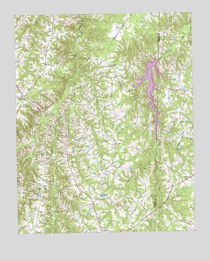
Ridgeville, NC USGS Topographic Map
Click on map above to begin viewing in our Map Viewer.

This topographic map contains these locations and features:
Feature Name Type Latitude Longitude GNIS ID View Map
Allens ChapelChurchN36.3399°W79.1789°980120View Map
Bethel ChurchChurchN36.2979°W79.1806°981171View Map
Beulah ChurchChurchN36.3668°W79.2236°981278View Map
Carvers LakeReservoirN36.2863°W79.1694°1000468View Map
Carvers Lake DamDamN36.2851°W79.1697°1000467View Map
Coneys CreekStreamN36.3432°W79.2059°983449View Map
Cooper CemeteryCemeteryN36.2876°W79.2003°983504View Map
Corbett RidgeRidgeN36.2854°W79.2306°983539View Map
FrogsboroPopulated PlaceN36.3454°W79.1820°1006211View Map
GordontonPopulated PlaceN36.2810°W79.1270°1006221View Map
Griers ChurchChurchN36.3474°W79.2195°986146View Map
Hebron ChurchChurchN36.3224°W79.2431°986584View Map
Hesters Grove ChurchChurchN36.3126°W79.1328°986673View Map
Hesters StoreLocaleN36.3301°W79.1303°986674View Map
HightowersPopulated PlaceN36.3271°W79.2434°1006239View Map
Hurdle Mills Volunteer Fire Department Station 2 Hester StoreBuildingN36.3297°W79.1301°2638385View Map
Hyco ChurchChurchN36.2690°W79.2328°987304View Map
Lea Bethel ChurchChurchN36.2879°W79.1833°988243View Map
Lynch CreekStreamN36.3224°W79.2209°989144View Map
Morgans PondReservoirN36.2713°W79.1901°990243View Map
Negro CreekStreamN36.3043°W79.2381°990897View Map
Panther BranchStreamN36.3376°W79.2106°991823View Map
Prospect Hill ChurchChurchN36.2693°W79.1925°992853View Map
Prospect Hill Volunteer Fire DepartmentBuildingN36.2985°W79.2145°2639200View Map
RidgevillePopulated PlaceN36.3004°W79.1806°1022288View Map
Salem Methodist Church CemeteryCemeteryN36.3021°W79.1256°1966683View Map
Salem United Methodist ChurchChurchN36.3026°W79.1253°994178View Map
Sugartree CreekStreamN36.2979°W79.1514°995662View Map
Township of HightowersCivilN36.2972°W79.2113°1026516View Map
Warrens ChapelChurchN36.2587°W79.1936°996807View Map

Note: Coordinates in the location and feature list above are referenced to NAD83 datum.


Copyright (C) 2008-2024 Ryan Niemi / Sunset Dynamics ... All Rights Reserved