TopoQuest Logo
Do you find TopoQuest useful?
Help keep TopoQuest running and adding new maps/features by donating!
Bitcoin:  19c7KJd3qBynnjoSw5npx9KScwjBe4ifkT
Litecoin:  LXs6TkuXGGXo1vDsWCkWVdjQX94eUKd6ui
Home View Maps Find Maps Find Places Resources & Links


Pottsboro, Texas Topographic Map

USGS Map Title: Pottsboro, TX
USGS Map MRC: 33096G6
DRG (GeoTIFF) Download: o33096g6.tif


Neighboring USGS Topographic Map Quads:


  Shay, OK  
33096H7
 

  Kingston South, OK  
33096H6
 

  Platter, OK  
33096H5
 

  Gordonville, TX  
33096G7
 

  Pottsboro, TX  
33096G6
 

  Denison Dam, TX  
33096G5
 

  Sadler, TX  
33096F7
 

  Sherman NW, TX  
33096F6
 

  Sherman, TX  
33096F5


Map MRC Location:

N34°
W97°
N34°
W96°
H8 H7 H6 H5 H4 H3 H2 H1
G8 G7 G6 G5 G4 G3 G2 G1
F8 F7 F6 F5 F4 F3 F2 F1
E8 E7 E6 E5 E4 E3 E2 E1
D8 D7 D6 D5 D4 D3 D2 D1
C8 C7 C6 C5 C4 C3 C2 C1
B8 B7 B6 B5 B4 B3 B2 B1
A8 A7 A6 A5 A4 A3 A2 A1
N33°
W97°
N33°
W96°

Pottsboro, TX USGS 1:24K Topographic Map Preview:
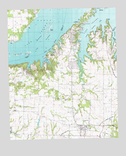
Pottsboro, TX USGS Topographic Map
Click on map above to begin viewing in our Map Viewer.

This topographic map contains these locations and features:
Feature Name Type Latitude Longitude GNIS ID View Map
CambridgePopulated PlaceN33.8112°W96.7281°1384207View Map
Coast Guard Auxiliary Lake Fire StationBuildingN33.8333°W96.6930°2551481View Map
Community ChurchChurchN33.8520°W96.6769°1889636View Map
Diamond J AirportAirportN33.8106°W96.7039°1889997View Map
FinkPopulated PlaceN33.8037°W96.6772°1379765View Map
First Baptist ChurchChurchN33.7579°W96.6667°2018602View Map
Georgetown CemeteryCemeteryN33.7873°W96.6881°1357961View Map
Grandpappy PointCapeN33.8590°W96.6431°1358255View Map
Grandpappy Point Landing Strip (historical)AirportN33.8526°W96.6464°1889639View Map
Grandpappy Point ParkParkN33.8479°W96.6481°2028268View Map
Hagerman CemeteryCemeteryN33.7545°W96.7439°1358623View Map
Henderson FerryLocaleN33.8362°W96.7003°1377155View Map
Highport Public Use AreaParkN33.8307°W96.7000°1889635View Map
Hitex Private AirportAirportN33.8418°W96.6697°1387359View Map
Island View ParkParkN33.8595°W96.6711°2029164View Map
Island View Public Use AreaParkN33.8615°W96.6683°1889638View Map
Lake CemeteryCemeteryN33.8490°W96.7455°1094464View Map
Lakeway United Methodist ChurchChurchN33.7838°W96.6761°2723903View Map
LarkLocaleN33.8509°W96.7447°1777910View Map
Little Mineral ArmBayN33.8482°W96.6617°1361407View Map
Little Mineral CreekStreamN33.8284°W96.6647°1361408View Map
Loes Highport Landing Strip (historical)AirportN33.8309°W96.7058°1889634View Map
North IslandIslandN33.8548°W96.6942°1777909View Map
PottsboroPopulated PlaceN33.7593°W96.6694°1365691View Map
Pottsboro City HallBuildingN33.7644°W96.6521°2753888View Map
Pottsboro Fire DepartmentBuildingN33.7598°W96.6680°2551559View Map
Pottsboro Police DepartmentBuildingN33.7594°W96.6684°2739020View Map
Pottsboro Post OfficePost OfficeN33.7627°W96.6753°2731156View Map
Preston Bend ParkParkN33.8632°W96.6611°2029505View Map
Preston Census Designated PlaceCensusN33.8671°W96.6595°2586975View Map
Preston PeninsulaCapeN33.8545°W96.6736°1889637View Map
Preston Volunteer Emergency Medical Services Station 1BuildingN33.8482°W96.6787°2551616View Map
Preston Volunteer Emergency Medical Services Station 2BuildingN33.8116°W96.7264°2551614View Map
Rocky PointCapeN33.8632°W96.6353°1366802View Map
Russell DamDamN33.7618°W96.7169°1858299View Map
Russell LakeReservoirN33.7618°W96.7169°1858300View Map
Texoma Landing Field (historical)AirportN33.8148°W96.7344°1889633View Map
The IslandsIslandN33.8565°W96.7039°1098835View Map
Town of PottsboroCivilN33.7709°W96.6710°2412503View Map
Willow SpringPopulated PlaceN33.7779°W96.7450°1889632View Map
Willow Springs ChurchChurchN33.7884°W96.7444°1371673View Map
Willow Springs SchoolSchoolN33.7770°W96.7461°1371676View Map

Note: Coordinates in the location and feature list above are referenced to NAD83 datum.


Copyright (C) 2008-2024 Ryan Niemi / Sunset Dynamics ... All Rights Reserved