TopoQuest Logo
Do you find TopoQuest useful?
Help keep TopoQuest running and adding new maps/features by donating!
Bitcoin:  19c7KJd3qBynnjoSw5npx9KScwjBe4ifkT
Litecoin:  LXs6TkuXGGXo1vDsWCkWVdjQX94eUKd6ui
Home View Maps Find Maps Find Places Resources & Links


Ponca, Arkansas Topographic Map

USGS Map Title: Ponca, AR
USGS Map MRC: 36093A3
DRG (GeoTIFF) Download: o36093a3.tif


Neighboring USGS Topographic Map Quads:


  Osage, AR  
36093B4
 

  Osage NE, AR  
36093B3
 

  Gaither, AR  
36093B2
 

  Osage SW, AR  
36093A4
 

  Ponca, AR  
36093A3
 

  Jasper, AR  
36093A2
 

  Boxley, AR  
35093H4
 

  Murray, AR  
35093H3
 

  Parthenon, AR  
35093H2


Map MRC Location:

N37°
W94°
N37°
W93°
H8 H7 H6 H5 H4 H3 H2 H1
G8 G7 G6 G5 G4 G3 G2 G1
F8 F7 F6 F5 F4 F3 F2 F1
E8 E7 E6 E5 E4 E3 E2 E1
D8 D7 D6 D5 D4 D3 D2 D1
C8 C7 C6 C5 C4 C3 C2 C1
B8 B7 B6 B5 B4 B3 B2 B1
A8 A7 A6 A5 A4 A3 A2 A1
N36°
W94°
N36°
W93°

Ponca, AR USGS 1:24K Topographic Map Preview:
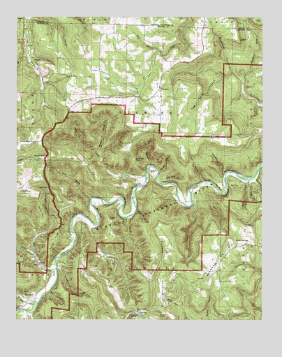
Ponca, AR USGS Topographic Map
Click on map above to begin viewing in our Map Viewer.

This topographic map contains these locations and features:
Feature Name Type Latitude Longitude GNIS ID View Map
Adds CreekStreamN36.0270°W93.3655°45792View Map
Bartlett CoveValleyN36.1009°W93.2599°46125View Map
Bear Cave HollowValleyN36.0573°W93.2988°46203View Map
Bear CreekStreamN36.0562°W93.2824°46207View Map
Bee BluffCliffN36.0445°W93.3330°46293View Map
Bee BluffCliffN36.0554°W93.2724°46294View Map
Beech CreekStreamN36.0415°W93.3182°46313View Map
BeechwoodPopulated PlaceN36.0081°W93.3691°76285View Map
Beechwood CemeteryCemeteryN36.0092°W93.3674°81813View Map
Big BluffCliffN36.0492°W93.3196°46506View Map
Big HollowValleyN36.0112°W93.3582°46566View Map
Broadwater HollowValleyN36.1023°W93.2657°46972View Map
Buffalo National River (Ponca Unit) WildernessReserveN36.0559°W93.3138°2035073View Map
Buzzard BluffCliffN36.0523°W93.2685°47244View Map
Calftail CutGapN36.0548°W93.3591°47279View Map
California PointCapeN36.0670°W93.3160°47282View Map
Camp OrrLocaleN36.0581°W93.2674°47331View Map
Cecil HollowValleyN36.0584°W93.2699°47560View Map
Clark CreekStreamN36.0067°W93.3641°47803View Map
Clemmons HollowValleyN36.0584°W93.2702°47847View Map
Cliff HollowValleyN36.0506°W93.3374°47853View Map
ComptonPopulated PlaceN36.0967°W93.3027°57576View Map
Compton Lookout TowerTowerN36.0531°W93.3727°82007View Map
Compton Post OfficePost OfficeN36.0925°W93.3063°2781893View Map
Compton School (historical)SchoolN36.0956°W93.3016°69917View Map
Compton Volunteer Fire DepartmentBuildingN36.1028°W93.2994°2116293View Map
Dewey CoveValleyN36.0056°W93.2921°48499View Map
Dry CreekStreamN36.0592°W93.2538°71440View Map
Dry CreekStreamN36.0034°W93.3705°70395View Map
Fisher PointSummitN36.0417°W93.3285°57753View Map
Fishtrap HollowValleyN36.0615°W93.3027°49072View Map
Gar Hole BluffCliffN36.0623°W93.2671°49328View Map
George RidgeRidgeN36.0317°W93.3571°49375View Map
Gossett HollowValleyN36.0281°W93.3668°49524View Map
Hanner PointCapeN36.0442°W93.3624°49827View Map
Haw GapGapN36.0829°W93.3510°49948View Map
Hemmed-In HollowValleyN36.0642°W93.3074°49999View Map
Hideout HollowValleyN36.0940°W93.2605°81824View Map
Horseshoe BendBendN36.0626°W93.3063°50336View Map
Indian CreekStreamN36.0492°W93.2860°50494View Map
Jackie HollowValleyN36.0745°W93.3432°50542View Map
Jackies Big HollowValleyN36.0451°W93.3141°50543View Map
Jim BluffCliffN36.0545°W93.3152°50646View Map
Jones CemeteryCemeteryN36.0962°W93.2674°81825View Map
Kilgore MountainSummitN36.0306°W93.2988°58017View Map
Kosky PointCapeN36.1245°W93.2516°72271View Map
Kyles LandingLocaleN36.0565°W93.2796°81826View Map
Lamb CoveValleyN36.1137°W93.2518°72282View Map
Leatherwood CreekStreamN36.0212°W93.3546°72297View Map
Lick FordLocaleN36.0565°W93.3013°51149View Map
Lost Valley State ParkParkN36.0104°W93.3743°51478View Map
Low GapLocaleN36.0037°W93.3132°77561View Map
Low Gap School (historical)SchoolN36.0042°W93.3127°69926View Map
Low Gap SpringSpringN36.0023°W93.3158°51494View Map
McFerrin CemeteryCemeteryN36.0762°W93.2718°51834View Map
McFerrin PointCapeN36.0759°W93.2563°81827View Map
Middle Prong Sneeds CreekStreamN36.0676°W93.3324°51937View Map
Mount ShermanPopulated PlaceN36.0309°W93.2563°77743View Map
Mount Sherman CemeteryCemeteryN36.0159°W93.2718°52412View Map
Mount Sherman School (historical)SchoolN36.0312°W93.2552°69932View Map
Mount Sherman Volunteer Fire DepartmentBuildingN36.0315°W93.2564°2116823View Map
Mount Sherman Volunteer Fire Department Low Gap SubstationBuildingN36.0042°W93.3139°2116824View Map
Mountain Springs CemeteryCemeteryN36.0667°W93.3663°52495View Map
Mountain Springs ChurchChurchN36.0734°W93.3668°52497View Map
Mountain Springs School (historical)SchoolN36.0731°W93.3671°69933View Map
Newground HollowValleyN36.1079°W93.3685°52753View Map
Pickert PointCapeN36.0812°W93.3393°53344View Map
Plumlee (historical)Populated PlaceN36.0542°W93.2821°69937View Map
Plumlee ChurchChurchN36.1034°W93.3335°53631View Map
Plumlee School (historical)SchoolN36.1023°W93.3332°69938View Map
PoncaPopulated PlaceN36.0242°W93.3646°53673View Map
Ponca CreekStreamN36.0212°W93.3549°53674View Map
Ponca Post OfficePost OfficeN36.0224°W93.3626°84505View Map
Ponca Volunteer Fire DepartmentBuildingN36.0247°W93.3651°2116994View Map
Queen PointCapeN36.1159°W93.2627°53861View Map
Raney CoveValleyN36.0592°W93.2538°73234View Map
Roark BluffCliffN36.0440°W93.3421°81830View Map
Rock Bridge CreekStreamN36.0567°W93.2574°54084View Map
Rocky HollowValleyN36.0259°W93.3291°54145View Map
Running CreekStreamN36.0026°W93.3671°73436View Map
Scout BendBendN36.0601°W93.2674°1958448View Map
Shop CreekStreamN36.0590°W93.2546°54818View Map
Sneeds CreekStreamN36.0587°W93.3093°78394View Map
Steel CreekStreamN36.0384°W93.3341°55187View Map
Tiggs Spring HollowValleyN36.1006°W93.2710°55571View Map
Township of Low GapCivilN36.0065°W93.3077°69683View Map
Township of PlumleeCivilN36.0843°W93.3065°69688View Map
Wolf BranchStreamN36.1109°W93.3030°56477View Map

Note: Coordinates in the location and feature list above are referenced to NAD83 datum.


Copyright (C) 2008-2024 Ryan Niemi / Sunset Dynamics ... All Rights Reserved