TopoQuest Logo
Do you find TopoQuest useful?
Help keep TopoQuest running and adding new maps/features by donating!
Bitcoin:  19c7KJd3qBynnjoSw5npx9KScwjBe4ifkT
Litecoin:  LXs6TkuXGGXo1vDsWCkWVdjQX94eUKd6ui
Home View Maps Find Maps Find Places Resources & Links


Plainfield, Vermont Topographic Map

USGS Map Title: Plainfield, VT
USGS Map MRC: 44072C4
DRG (GeoTIFF) Download: o44072c4.tif


Neighboring USGS Topographic Map Quads:


  Mount Worcester, VT  
44072D5
 

  Woodbury, VT  
44072D4
 

  Cabot, VT  
44072D3
 

  Montpelier, VT  
44072C5
 

  Plainfield, VT  
44072C4
 

  Marshfield, VT  
44072C3
 

  Barre West, VT  
44072B5
 

  Barre East, VT  
44072B4
 

  Knox Mountain, VT  
44072B3


Map MRC Location:

N45°
W73°
N45°
W72°
H8 H7 H6 H5 H4 H3 H2 H1
G8 G7 G6 G5 G4 G3 G2 G1
F8 F7 F6 F5 F4 F3 F2 F1
E8 E7 E6 E5 E4 E3 E2 E1
D8 D7 D6 D5 D4 D3 D2 D1
C8 C7 C6 C5 C4 C3 C2 C1
B8 B7 B6 B5 B4 B3 B2 B1
A8 A7 A6 A5 A4 A3 A2 A1
N44°
W73°
N44°
W72°

Plainfield, VT USGS 1:24K Topographic Map Preview:
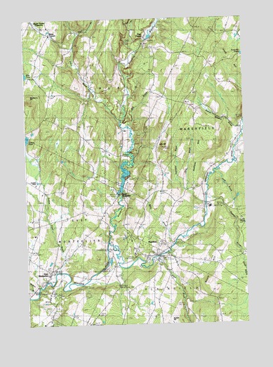
Plainfield, VT USGS Topographic Map
Click on map above to begin viewing in our Map Viewer.

This topographic map contains these locations and features:
Feature Name Type Latitude Longitude GNIS ID View Map
Ainsworth CemeteryCemeteryN44.3676°W72.4604°1918978View Map
Bartlett HillSummitN44.2523°W72.4204°1456279View Map
Beaver Meadow BrookStreamN44.3298°W72.3757°1456350View Map
Blackberry HillSummitN44.3378°W72.4909°1456458View Map
Bliss CemeteryCemeteryN44.3635°W72.4250°1456471View Map
Calais Elementary SchoolSchoolN44.3195°W72.4519°2427443View Map
Calais Town ForestForestN44.3564°W72.4976°1919012View Map
Carr BrookStreamN44.3609°W72.4357°1456774View Map
Cate CemeteryCemeteryN44.2842°W72.4529°1919015View Map
Cate CemeteryCemeteryN44.2840°W72.4528°1456790View Map
Center CemeteryCemeteryN44.3684°W72.4601°1456814View Map
Center SchoolSchoolN44.2606°W72.4268°1456824View Map
Coburn Covered BridgeBridgeN44.2809°W72.4540°1919025View Map
Cold BrookStreamN44.3109°W72.3923°1456968View Map
Crystal PoolLakeN44.3086°W72.4930°1457068View Map
Dwinell SchoolSchoolN44.3401°W72.4051°1457230View Map
East CalaisPopulated PlaceN44.3664°W72.4298°1457265View Map
East Calais Post OfficePost OfficeN44.3675°W72.4299°1919040View Map
East MontpelierPopulated PlaceN44.2712°W72.4871°1457298View Map
East Montpelier Census Designated PlaceCensusN44.2695°W72.4880°2584789View Map
East Montpelier Elementary SchoolSchoolN44.2869°W72.4952°2427469View Map
East Montpelier Fire DepartmentBuildingN44.2703°W72.4859°2121365View Map
East Montpelier Post OfficePost OfficeN44.2704°W72.4875°1919041View Map
East Montpelier Village CemeteryCemeteryN44.2685°W72.4870°1919043View Map
East Village Meeting HouseChurchN44.2717°W72.4865°1919046View Map
Eaton CemeteryCemeteryN44.3057°W72.4039°1457329View Map
Fairview CemeteryCemeteryN44.3628°W72.4247°1919054View Map
Four Corners SchoolSchoolN44.2901°W72.4934°1457479View Map
Goddard CollegeSchoolN44.2790°W72.4384°1457559View Map
Grace United Methodist ChurchChurchN44.2776°W72.4248°1919061View Map
Great BrookStreamN44.2773°W72.4279°1457624View Map
Gritt HillSummitN44.3226°W72.4209°1457654View Map
Guernsey BrookStreamN44.3051°W72.4076°1457665View Map
Hollister HillSummitN44.3242°W72.3918°1457871View Map
Kent Tavern (historical)BuildingN44.3687°W72.4851°1919092View Map
Kents Corner Historic DistrictParkN44.3687°W72.4851°1919090View Map
Kents CornersPopulated PlaceN44.3687°W72.4851°1458073View Map
Kents MuseumBuildingN44.3687°W72.4851°1919091View Map
King BrookStreamN44.2992°W72.3976°1458090View Map
King SchoolSchoolN44.2978°W72.3990°1458096View Map
Kingsbury BranchStreamN44.2828°W72.4537°1458104View Map
Kingsbury Branch Community SchoolSchoolN44.2784°W72.4245°2427434View Map
Kingsbury BrookStreamN44.3331°W72.4451°1458105View Map
Knob HillSummitN44.3553°W72.3751°1458120View Map
Little Woolen Company Mill (historical)LocaleN44.3034°W72.4473°1919101View Map
Lye BrookStreamN44.2914°W72.3804°1458316View Map
Mallory BrookStreamN44.2634°W72.4940°1458341View Map
Maple HillSummitN44.2670°W72.3968°1458348View Map
Martin Covered BridgeBridgeN44.2842°W72.4143°1919114View Map
Mskaskek BrookStreamN44.2608°W72.4110°2785818View Map
Nasmith BrookStreamN44.3009°W72.3970°1458650View Map
Nasmith CemeteryCemeteryN44.2784°W72.3768°1919138View Map
North MontpelierPopulated PlaceN44.3037°W72.4465°1458748View Map
North Montpelier PondReservoirN44.3090°W72.4442°1766442View Map
North Montpelier Pond Upper DamDamN44.3034°W72.4462°1766441View Map
Old West ChurchChurchN44.3592°W72.4896°1919166View Map
Old West ChurchChurchN44.3592°W72.4929°1458838View Map
Old West Church CemeteryCemeteryN44.3591°W72.4934°1919167View Map
Onion River Camp AreaLocaleN44.3001°W72.3959°1919169View Map
Orchard Valley SchoolSchoolN44.2945°W72.4561°2427470View Map
Pekin BrookStreamN44.3309°W72.4407°1458930View Map
Pekin SchoolSchoolN44.3459°W72.4598°1458931View Map
Pike CemeteryCemeteryN44.3494°W72.3891°1458964View Map
PlainfieldPopulated PlaceN44.2781°W72.4265°1461779View Map
Plainfield Census Designated PlaceCensusN44.2766°W72.4270°2584791View Map
Plainfield Fire and Rescue DepartmentBuildingN44.2779°W72.4225°2121361View Map
Plainfield Fire and Rescue SquadBuildingN44.2776°W72.4287°2578137View Map
Plainfield Post OfficePost OfficeN44.2778°W72.4318°1919178View Map
Plainfield Town ForestForestN44.3295°W72.4304°1919180View Map
Plainfield Village Historic DistrictParkN44.2784°W72.4259°1919181View Map
Plainmont CemeteryCemeteryN44.2745°W72.4512°1458995View Map
Potter BrookStreamN44.2751°W72.3762°1459061View Map
Rich-Hollister CemeteryCemeteryN44.3035°W72.4208°1919185View Map
Short CemeteryCemeteryN44.3311°W72.4698°1459501View Map
Sodom PondLakeN44.3259°W72.5000°1459559View Map
Sodom Pond BrookStreamN44.2709°W72.4832°1459560View Map
Spooners Trailer Park and CampgroundLocaleN44.3281°W72.3784°1919214View Map
Still BrookStreamN44.3312°W72.4407°1459717View Map
The Maplehill SchoolSchoolN44.2629°W72.4025°2427368View Map
Town of CalaisCivilN44.3649°W72.4657°1462062View Map
Twinfield Union SchoolSchoolN44.2980°W72.3949°2427362View Map
Village CemeteryCemeteryN44.2784°W72.4216°1919251View Map
Washington Northeast Supervisory UnionSchoolN44.2978°W72.3985°2427385View Map
Wells BrookStreamN44.2828°W72.4157°1460103View Map
WGDR-FM (Plainfield)TowerN44.2845°W72.4407°1461898View Map

Note: Coordinates in the location and feature list above are referenced to NAD83 datum.


Copyright (C) 2008-2024 Ryan Niemi / Sunset Dynamics ... All Rights Reserved