TopoQuest Logo
Do you find TopoQuest useful?
Help keep TopoQuest running and adding new maps/features by donating!
Bitcoin:  19c7KJd3qBynnjoSw5npx9KScwjBe4ifkT
Litecoin:  LXs6TkuXGGXo1vDsWCkWVdjQX94eUKd6ui
Home View Maps Find Maps Find Places Resources & Links


Pittsfield, New Hampshire Topographic Map

USGS Map Title: Pittsfield, NH
USGS Map MRC: 43071C3
DRG (GeoTIFF) Download: o43071c3.tif


Neighboring USGS Topographic Map Quads:


  Belmont, NH  
43071D4
 

  Gilmanton Ironworks, NH  
43071D3
 

  Alton, NH  
43071D2
 

  Loudon, NH  
43071C4
 

  Pittsfield, NH  
43071C3
 

  Parker Mountain, NH  
43071C2
 

  Suncook, NH  
43071B4
 

  Gossville, NH  
43071B3
 

  Northwood, NH  
43071B2


Map MRC Location:

N44°
W72°
N44°
W71°
H8 H7 H6 H5 H4 H3 H2 H1
G8 G7 G6 G5 G4 G3 G2 G1
F8 F7 F6 F5 F4 F3 F2 F1
E8 E7 E6 E5 E4 E3 E2 E1
D8 D7 D6 D5 D4 D3 D2 D1
C8 C7 C6 C5 C4 C3 C2 C1
B8 B7 B6 B5 B4 B3 B2 B1
A8 A7 A6 A5 A4 A3 A2 A1
N43°
W72°
N43°
W71°

Pittsfield, NH USGS 1:24K Topographic Map Preview:
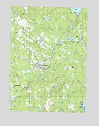
Pittsfield, NH USGS Topographic Map
Click on map above to begin viewing in our Map Viewer.

This topographic map contains these locations and features:
Feature Name Type Latitude Longitude GNIS ID View Map
Advent Christian ChurchChurchN43.3037°W71.3251°1916928View Map
Appleview OrchardLocaleN43.3250°W71.3433°2611135View Map
BarnsteadPopulated PlaceN43.3340°W71.2928°865385View Map
Barnstead Elementary SchoolSchoolN43.3484°W71.2621°1914981View Map
Barnstead Fire and RescueBuildingN43.3353°W71.2913°2605328View Map
Barnstead Fire Rescue Station 2BuildingN43.3400°W71.2595°2605059View Map
Barnstead Parade ChurchChurchN43.3340°W71.2926°1914982View Map
Barnstead Parade DamDamN43.3317°W71.2912°1775166View Map
Barnstead Post OfficePost OfficeN43.3339°W71.2933°1914983View Map
Beauty HillSummitN43.3695°W71.3065°865468View Map
Berry CemeteryCemeteryN43.2994°W71.3075°865554View Map
Berry PondReservoirN43.2799°W71.3011°1774945View Map
Berry Pond BrookStreamN43.2940°W71.3206°865557View Map
Berry Pond DamDamN43.2834°W71.2962°1774944View Map
Big RiverStreamN43.3367°W71.2623°865581View Map
Blake PondLakeN43.2622°W71.2901°865651View Map
Carpenter Memorial LibraryBuildingN43.3054°W71.3295°1916983View Map
Catamount MountainSummitN43.2756°W71.2951°866041View Map
Center BarnsteadPopulated PlaceN43.3392°W71.2595°866074View Map
Center Barnstead Police DeptBuildingN43.3389°W71.2594°2752952View Map
Center Barnstead Post OfficePost OfficeN43.3420°W71.2634°1915011View Map
Chestnut PondLakeN43.2506°W71.2894°866148View Map
Crooked RunStreamN43.3337°W71.2740°866410View Map
Eaton PondLakeN43.2703°W71.2814°866756View Map
Floral Park CemeteryCemeteryN43.3098°W71.3201°866902View Map
Floral Park CemeteryCemeteryN43.3065°W71.3245°1917068View Map
Friends MeetinghouseChurchN43.2654°W71.3148°866989View Map
Huntress PondLakeN43.3515°W71.2762°867687View Map
Jenness HillSummitN43.3267°W71.3453°867768View Map
Kelley BrookStreamN43.3240°W71.3040°867826View Map
Kelleys CornerPopulated PlaceN43.2917°W71.3606°871193View Map
Kelleys CornerPopulated PlaceN43.3684°W71.3542°867827View Map
Leavitt HillSummitN43.3126°W71.3453°867968View Map
Lily LakeLakeN43.3354°W71.3255°868004View Map
Loudon SchoolSchoolN43.3376°W71.3620°868184View Map
Lougee PondLakeN43.3596°W71.3154°868185View Map
Lower Suncook LakeLakeN43.3730°W71.2683°868208View Map
Mount Calvary CemeteryCemeteryN43.3152°W71.3360°868591View Map
North ChichesterPopulated PlaceN43.2576°W71.3726°868778View Map
Nudds HillSummitN43.2679°W71.3412°868855View Map
Odiorne PondLakeN43.2529°W71.3218°868885View Map
Perry BrookStreamN43.3412°W71.2631°869089View Map
Perry BrookStreamN43.2654°W71.3665°869094View Map
Pine Ground CemeteryCemeteryN43.2597°W71.3722°869158View Map
PittsfieldPopulated PlaceN43.3059°W71.3242°869241View Map
Pittsfield Census Designated PlaceCensusN43.2997°W71.3322°2378088View Map
Pittsfield Center Historic DistrictParkN43.3042°W71.3262°1917260View Map
Pittsfield Church of GodChurchN43.3095°W71.3292°1917258View Map
Pittsfield Community CenterBuildingN43.3037°W71.3253°1917259View Map
Pittsfield Elementary SchoolSchoolN43.3053°W71.3159°1917261View Map
Pittsfield FairgroundsLocaleN43.3112°W71.3340°1917262View Map
Pittsfield Fire DepartmentBuildingN43.3047°W71.3220°2605177View Map
Pittsfield High SchoolSchoolN43.3036°W71.3170°1917395View Map
Pittsfield Middle SchoolSchoolN43.3032°W71.3170°1917263View Map
Pittsfield Mill DamDamN43.3067°W71.3295°1774973View Map
Pittsfield Police DepartmentBuildingN43.3035°W71.3262°2752860View Map
Pittsfield Post OfficePost OfficeN43.3060°W71.3267°1917264View Map
Rings CornerPopulated PlaceN43.3140°W71.3612°871221View Map
Riverview CemeteryCemeteryN43.3397°W71.2804°869521View Map
Rollins PondLakeN43.3648°W71.3670°869593View Map
Sanborn BrookStreamN43.2776°W71.3653°869759View Map
Sanborn HillSummitN43.3598°W71.3581°869763View Map
Sanders BrookStreamN43.2556°W71.3734°869775View Map
Suncook LakeReservoirN43.3601°W71.2678°1774775View Map
Suncook Lake DamDamN43.3601°W71.2678°1774774View Map
Suncook River ReservoirReservoirN43.3317°W71.2912°1775167View Map
Tilton HillSummitN43.3017°W71.2801°870440View Map
Tilton Hill CemeteryCemeteryN43.3026°W71.2813°1917342View Map
Town of BarnsteadCivilN43.3513°W71.2554°873537View Map
Town of PittsfieldCivilN43.2939°W71.3105°873699View Map
Webster StreamStreamN43.3512°W71.2534°870709View Map
Websters MillPopulated PlaceN43.2784°W71.3453°870710View Map
Wheeler BrookStreamN43.3315°W71.2981°870815View Map
Whites PondReservoirN43.3024°W71.3109°870861View Map
Whites Pond Outlet DamDamN43.3034°W71.3162°1774946View Map

Note: Coordinates in the location and feature list above are referenced to NAD83 datum.


Copyright (C) 2008-2024 Ryan Niemi / Sunset Dynamics ... All Rights Reserved