TopoQuest Logo
Do you find TopoQuest useful?
Help keep TopoQuest running and adding new maps/features by donating!
Bitcoin:  19c7KJd3qBynnjoSw5npx9KScwjBe4ifkT
Litecoin:  LXs6TkuXGGXo1vDsWCkWVdjQX94eUKd6ui
Home View Maps Find Maps Find Places Resources & Links


Pikes Peak, Colorado Topographic Map

USGS Map Title: Pikes Peak, CO
USGS Map MRC: 38105G1
DRG (GeoTIFF) Download: o38105g1.tif


Neighboring USGS Topographic Map Quads:


  Divide, CO  
38105H2
 

  Woodland Park, CO  
38105H1
 

  Cascade, CO  
38104H8
 

  Cripple Creek North, CO  
38105G2
 

  Pikes Peak, CO  
38105G1
 

  Manitou Springs, CO  
38104G8
 

  Cripple Creek South, CO  
38105F2
 

  Big Bull Mountain, CO  
38105F1
 

  Mount Big Chief, CO  
38104F8


Map MRC Location:

N39°
W106°
N39°
W105°
H8 H7 H6 H5 H4 H3 H2 H1
G8 G7 G6 G5 G4 G3 G2 G1
F8 F7 F6 F5 F4 F3 F2 F1
E8 E7 E6 E5 E4 E3 E2 E1
D8 D7 D6 D5 D4 D3 D2 D1
C8 C7 C6 C5 C4 C3 C2 C1
B8 B7 B6 B5 B4 B3 B2 B1
A8 A7 A6 A5 A4 A3 A2 A1
N38°
W106°
N38°
W105°

Pikes Peak, CO USGS 1:24K Topographic Map Preview:
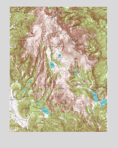
Pikes Peak, CO USGS Topographic Map
Click on map above to begin viewing in our Map Viewer.

This topographic map contains these locations and features:
Feature Name Type Latitude Longitude GNIS ID View Map
Altman DamDamN38.7517°W105.1019°191243View Map
Barr TrailTrailN38.8483°W105.0169°203534View Map
Big Horn DamDamN38.8250°W105.0639°201494View Map
Bighorn ReservoirReservoirN38.8258°W105.0612°201495View Map
Bison Park DamDamN38.7717°W105.0855°201320View Map
Bison ReservoirReservoirN38.7709°W105.0794°201321View Map
Black ForestForestN38.8489°W105.1116°203533View Map
Boehmer CreekStreamN38.7911°W105.0211°191247View Map
Boehmer DamDamN38.8083°W105.0383°201322View Map
Boehmer ReservoirReservoirN38.8096°W105.0403°198183View Map
Bottomless PitBasinN38.8539°W105.0466°191233View Map
Bull ParkFlatN38.7722°W105.0394°191240View Map
Cow MountainSummitN38.7580°W105.0847°191241View Map
Cripple Creek Number 2 DamDamN38.7900°W105.1105°199010View Map
Cripple Creek Number 2 ReservoirReservoirN38.7900°W105.1105°199011View Map
Cripple Creek Number 3 DamDamN38.7983°W105.1022°201532View Map
Cripple Creek Reservoir Number 3ReservoirN38.8000°W105.0993°201533View Map
Dead LakeLakeN38.7902°W105.0101°191239View Map
Devils PlaygroundAreaN38.8625°W105.0664°196494View Map
East Fork West Beaver CreekStreamN38.7547°W105.1033°191244View Map
Elk ParkFlatN38.7625°W105.0019°169352View Map
Gillett (historical)Populated PlaceN38.7819°W105.1228°203906View Map
Horsethief ParkFlatN38.8344°W105.1220°191231View Map
Mason DamDamN38.7805°W105.0136°201324View Map
Mason ReservoirReservoirN38.7851°W105.0159°198182View Map
McReynolds DamDamN38.7764°W105.0080°201326View Map
McReynolds ReservoirReservoirN38.7791°W105.0049°169455View Map
Pikes PeakSummitN38.8405°W105.0444°204770View Map
Sachett MountainSummitN38.8208°W105.0239°191234View Map
Saint John TunnelTunnelN38.7917°W105.0144°191236View Map
Sentinel PointSummitN38.8405°W105.1047°191230View Map
Seven Lakes (historical)Populated PlaceN38.7817°W105.0086°191253View Map
Sheep MountainSummitN38.7930°W105.0547°191238View Map
Strickler TunnelTunnelN38.8108°W105.0564°191246View Map
Summit HouseLocaleN38.8403°W105.0425°191232View Map
The Crags CampgroundLocaleN38.8711°W105.1216°197589View Map
The CraterBasinN38.8328°W105.0219°191237View Map
Trachyte KnobSummitN38.7733°W105.1066°203950View Map
Tracie Group MineMineN38.7750°W105.0422°1745955View Map
Victor Number 2 DamDamN38.7783°W105.0922°201534View Map
Victor Reservoir Number 2ReservoirN38.7783°W105.0922°201535View Map
West Fork West Beaver CreekStreamN38.7764°W105.1233°191245View Map
Wilson DamDamN38.8150°W105.0705°201328View Map
Wilson ReservoirReservoirN38.8166°W105.0710°201329View Map
Windy PointCliffN38.8144°W105.0216°191235View Map

Note: Coordinates in the location and feature list above are referenced to NAD83 datum.


Copyright (C) 2008-2024 Ryan Niemi / Sunset Dynamics ... All Rights Reserved