TopoQuest Logo
Do you find TopoQuest useful?
Help keep TopoQuest running and adding new maps/features by donating!
Bitcoin:  19c7KJd3qBynnjoSw5npx9KScwjBe4ifkT
Litecoin:  LXs6TkuXGGXo1vDsWCkWVdjQX94eUKd6ui
Home View Maps Find Maps Find Places Resources & Links


Piermont, New Hampshire Topographic Map

USGS Map Title: Piermont, NH
USGS Map MRC: 43072H1
DRG (GeoTIFF) Download: o43072h1.tif


Neighboring USGS Topographic Map Quads:


  East Corinth, VT  
44072A2
 

  Newbury, VT  
44072A1
 

  East Haverhill, NH  
44071A8
 

  Fairlee, VT  
43072H2
 

  Piermont, NH  
43072H1
 

  Warren, NH  
43071H8
 

  Lyme, NH  
43072G2
 

  Smarts Mountain, NH  
43072G1
 

  Wentworth, NH  
43071G8


Map MRC Location:

N44°
W73°
N44°
W72°
H8 H7 H6 H5 H4 H3 H2 H1
G8 G7 G6 G5 G4 G3 G2 G1
F8 F7 F6 F5 F4 F3 F2 F1
E8 E7 E6 E5 E4 E3 E2 E1
D8 D7 D6 D5 D4 D3 D2 D1
C8 C7 C6 C5 C4 C3 C2 C1
B8 B7 B6 B5 B4 B3 B2 B1
A8 A7 A6 A5 A4 A3 A2 A1
N43°
W73°
N43°
W72°

Piermont, NH USGS 1:24K Topographic Map Preview:
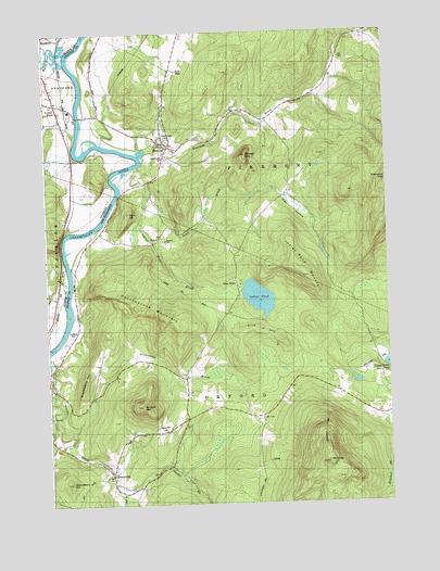
Piermont, NH USGS Topographic Map
Click on map above to begin viewing in our Map Viewer.

This topographic map contains these locations and features:
Feature Name Type Latitude Longitude GNIS ID View Map
Archertown BrookStreamN43.8951°W72.1165°865257View Map
Bean BrookStreamN43.9573°W72.0884°865425View Map
Blackberry HillRidgeN43.9081°W72.1106°865637View Map
Blooms MountainSummitN43.9187°W72.0395°871048View Map
Boynton SchoolSchoolN43.9448°W72.0823°865748View Map
Bradford Fire DepartmentBuildingN43.9893°W72.1210°2121333View Map
Camp WestonLocaleN43.9334°W72.0548°865958View Map
Cedar Grove CemeteryCemeteryN43.9720°W72.0810°866060View Map
Clay HollowValleyN43.9634°W72.0968°866201View Map
Clough BrookStreamN43.8784°W72.0973°866217View Map
Cottonstone MountainRidgeN43.9265°W72.0873°866364View Map
Dame HillSummitN43.8945°W72.0829°866459View Map
Dartmouth Outing Club CampLocaleN43.8870°W72.0479°1916509View Map
Eastman BrookStreamN43.9673°W72.0909°871840View Map
Echo HillSummitN43.9523°W72.0951°866758View Map
Grimes Hill RoadTrailN43.9306°W72.0756°867261View Map
Indian PondLakeN43.9296°W72.0475°867717View Map
Indian Pond BrookStreamN43.9634°W72.0968°867718View Map
Indian Pond MountainSummitN43.9351°W72.0298°867719View Map
Lower Plain Piermont StationLocaleN43.9817°W72.1201°1458303View Map
Mount CubeSummitN43.8856°W72.0231°868617View Map
Mount Cube Ski Touring CenterLocaleN43.8951°W72.0237°1916697View Map
Orford Police DepartmentBuildingN43.8821°W72.1024°2752940View Map
OrfordvillePopulated PlaceN43.8834°W72.1023°868926View Map
Peaked MountainSummitN43.9673°W72.0526°869041View Map
PiermontPopulated PlaceN43.9698°W72.0806°869139View Map
Piermont Fire DepartmentBuildingN43.9681°W72.0805°2605206View Map
Piermont First Aid Stabilization Team SquadBuildingN43.9681°W72.0805°2658892View Map
Piermont Post OfficePost OfficeN43.9710°W72.0815°1916757View Map
Piermont Village SchoolSchoolN43.9682°W72.0816°1916759View Map
South Lawn CemeteryCemeteryN43.9666°W72.0807°870041View Map
Strawberry HillSummitN43.8809°W72.1170°870233View Map
Sunday MountainSummitN43.9009°W72.0906°870276View Map
Town of OrfordCivilN43.8956°W72.0666°873693View Map
Town of PiermontCivilN43.9748°W72.0309°873698View Map
Waits RiverStreamN43.9948°W72.1159°1460038View Map

Note: Coordinates in the location and feature list above are referenced to NAD83 datum.


Copyright (C) 2008-2024 Ryan Niemi / Sunset Dynamics ... All Rights Reserved