TopoQuest Logo
Do you find TopoQuest useful?
Help keep TopoQuest running and adding new maps/features by donating!
Bitcoin:  19c7KJd3qBynnjoSw5npx9KScwjBe4ifkT
Litecoin:  LXs6TkuXGGXo1vDsWCkWVdjQX94eUKd6ui
Home View Maps Find Maps Find Places Resources & Links


Peoria, Indiana Topographic Map

USGS Map Title: Peoria, IN
USGS Map MRC: 40085F8
DRG (GeoTIFF) Download: o40085f8.tif


Neighboring USGS Topographic Map Quads:


  Peru, IN  
40086G1
 

  Richvalley, IN  
40085G8
 

  Wabash, IN  
40085G7
 

  Bunker Hill, IN  
40086F1
 

  Peoria, IN  
40085F8
 

  Somerset, IN  
40085F7
 

  Miami, IN  
40086E1
 

  Amboy, IN  
40085E8
 

  Sweetser, IN  
40085E7


Map MRC Location:

N41°
W86°
N41°
W85°
H8 H7 H6 H5 H4 H3 H2 H1
G8 G7 G6 G5 G4 G3 G2 G1
F8 F7 F6 F5 F4 F3 F2 F1
E8 E7 E6 E5 E4 E3 E2 E1
D8 D7 D6 D5 D4 D3 D2 D1
C8 C7 C6 C5 C4 C3 C2 C1
B8 B7 B6 B5 B4 B3 B2 B1
A8 A7 A6 A5 A4 A3 A2 A1
N40°
W86°
N40°
W85°

Peoria, IN USGS 1:24K Topographic Map Preview:
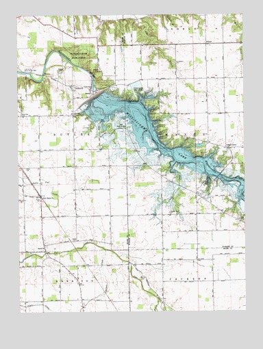
Peoria, IN USGS Topographic Map
Click on map above to begin viewing in our Map Viewer.

This topographic map contains these locations and features:
Feature Name Type Latitude Longitude GNIS ID View Map
Bond CemeteryCemeteryN40.6394°W85.9331°431313View Map
Clayton CemeteryCemeteryN40.7270°W85.9550°432601View Map
Cliffs of the Seven Double PillarsCliffN40.7262°W85.9925°432651View Map
College CornerPopulated PlaceN40.6987°W85.8855°432763View Map
Fegley CemeteryCemeteryN40.6723°W85.9878°434432View Map
Frances Slocum State ForestForestN40.7334°W85.9689°434750View Map
Frances Slocum State Recreation AreaParkN40.7178°W85.9330°434751View Map
Honey CreekStreamN40.6292°W85.9225°436389View Map
Johnson Heights DamDamN40.6945°W85.9017°448736View Map
Keyes CemeteryCemeteryN40.6856°W85.9958°437279View Map
Lake NiconzahReservoirN40.6949°W85.8997°448737View Map
Liston CreekStreamN40.6806°W85.9105°437981View Map
Miami State Recreation AreaParkN40.7025°W85.9400°439072View Map
Mississinewa LakeReservoirN40.6901°W85.9001°439290View Map
Mississinewa Lake DamDamN40.7084°W85.9583°448676View Map
Mount Pleasant CemeteryCemeteryN40.7300°W85.9130°439665View Map
New Hope CemeteryCemeteryN40.7081°W85.9983°440062View Map
New Santa FePopulated PlaceN40.6737°W85.9878°440116View Map
North Union CemeteryCemeteryN40.7295°W85.9272°440305View Map
PeoriaPopulated PlaceN40.7187°W85.9605°441011View Map
PioneerPopulated PlaceN40.7378°W85.8955°441179View Map
Pleasant Grove ChurchChurchN40.6662°W85.9158°441265View Map
Ramer CemeteryCemeteryN40.6549°W85.9700°441753View Map
Red BridgeBridgeN40.6812°W85.8894°446911View Map
Red Bridge State Recreation AreaParkN40.6784°W85.8953°441816View Map
Reserve Number Twenty-sixReserveN40.6959°W85.9061°446931View Map
Santa FePopulated PlaceN40.6531°W85.9861°443023View Map
Slocum CemeteryCemeteryN40.6981°W85.9080°443621View Map
Township of ButlerCivilN40.7063°W85.9776°453150View Map
Walnut CreekStreamN40.6512°W85.9525°445411View Map
Woodlawn ChurchChurchN40.7195°W85.9683°446296View Map

Note: Coordinates in the location and feature list above are referenced to NAD83 datum.


Copyright (C) 2008-2024 Ryan Niemi / Sunset Dynamics ... All Rights Reserved