TopoQuest Logo
Do you find TopoQuest useful?
Help keep TopoQuest running and adding new maps/features by donating!
Bitcoin:  19c7KJd3qBynnjoSw5npx9KScwjBe4ifkT
Litecoin:  LXs6TkuXGGXo1vDsWCkWVdjQX94eUKd6ui
Home View Maps Find Maps Find Places Resources & Links


Park City West, Utah Topographic Map

USGS Map Title: Park City West, UT
USGS Map MRC: 40111F5
DRG (GeoTIFF) Download: o40111f5.tif


Neighboring USGS Topographic Map Quads:


  Mountain Dell, UT  
40111G6
 

  Big Dutch Hollow, UT  
40111G5
 

  Wanship, UT  
40111G4
 

  Mount Aire, UT  
40111F6
 

  Park City West, UT  
40111F5
 

  Park City East, UT  
40111F4
 

  Dromedary Peak, UT  
40111E6
 

  Brighton, UT  
40111E5
 

  Heber City, UT  
40111E4


Map MRC Location:

N41°
W112°
N41°
W111°
H8 H7 H6 H5 H4 H3 H2 H1
G8 G7 G6 G5 G4 G3 G2 G1
F8 F7 F6 F5 F4 F3 F2 F1
E8 E7 E6 E5 E4 E3 E2 E1
D8 D7 D6 D5 D4 D3 D2 D1
C8 C7 C6 C5 C4 C3 C2 C1
B8 B7 B6 B5 B4 B3 B2 B1
A8 A7 A6 A5 A4 A3 A2 A1
N40°
W112°
N40°
W111°

Park City West, UT USGS 1:24K Topographic Map Preview:
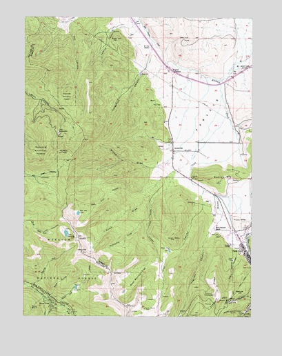
Park City West, UT USGS Topographic Map
Click on map above to begin viewing in our Map Viewer.

This topographic map contains these locations and features:
Feature Name Type Latitude Longitude GNIS ID View Map
Alliance TunnelMineN40.6263°W111.5055°1438164View Map
American Flag ShaftMineN40.6283°W111.5005°1425102View Map
Bear HollowBasinN40.7147°W111.5538°1438471View Map
Beartrap ForkStreamN40.6383°W111.6244°1438508View Map
Burnt FlatPopulated PlaceN40.6347°W111.6158°1452218View Map
City of Park CityCivilN40.6505°W111.5019°2411372View Map
Creole TunnelMineN40.6461°W111.5016°1440146View Map
Crescent RidgeRidgeN40.6366°W111.5196°1440152View Map
Crescent TunnelMineN40.6269°W111.5371°1440153View Map
Dry LakeLakeN40.6416°W111.5920°1440665View Map
Dunyon DellPopulated PlaceN40.6327°W111.6138°1449867View Map
Dutch DrawValleyN40.6858°W111.5430°1440737View Map
Ecker HillSummitN40.7408°W111.5752°1440863View Map
Forest HomePopulated PlaceN40.7066°W111.6163°1452736View Map
Glenwood CemeteryCemeteryN40.6544°W111.5119°1441334View Map
Hi Ute RanchLocaleN40.7374°W111.5574°1441730View Map
Holiday Village Shopping MallLocaleN40.6608°W111.5094°1455323View Map
Iron CanyonValleyN40.6763°W111.5274°1442046View Map
Iron MountainSummitN40.6572°W111.5433°1442050View Map
Judge TunnelMineN40.6261°W111.5035°1442240View Map
Kimball CreekStreamN40.7308°W111.5474°1442319View Map
Kimball JunctionPopulated PlaceN40.7272°W111.5441°1442320View Map
KPCW-FM (Park City)TowerN40.6830°W111.5235°1455811View Map
Lake DesolationLakeN40.6595°W111.6025°1440416View Map
Lake Desolation TrailTrailN40.6647°W111.6241°1442403View Map
Lake SalamanderReservoirN40.7011°W111.6068°1445261View Map
Mats BasinBasinN40.6283°W111.6194°1443227View Map
McDonald DrawValleyN40.6666°W111.5571°1443247View Map
McLeod CreekStreamN40.6952°W111.5074°1443266View Map
Mill F FlatFlatN40.6258°W111.6016°1443440View Map
Miners Hospital Community CenterBuildingN40.6532°W111.5039°2432456View Map
Mule HollowValleyN40.6336°W111.6105°1443731View Map
Murdock PeakSummitN40.6936°W111.6046°1443741View Map
Negro HollowValleyN40.6530°W111.5088°1443789View Map
NeilsonPopulated PlaceN40.6333°W111.6099°1452221View Map
Old Stage StationLocaleN40.7238°W111.5160°1454850View Map
Park City Baptist ChurchChurchN40.6611°W111.5113°1450626View Map
Park City CemeteryCemeteryN40.6622°W111.5036°1448803View Map
Park City DivisionCivilN40.7187°W111.5353°1939405View Map
Park City Fire District Station 31BuildingN40.6677°W111.5122°2627111View Map
Park City Fire District Station 33BuildingN40.7230°W111.5247°2627233View Map
Park City Fire District Station 35BuildingN40.7418°W111.5615°2627138View Map
Park City Fire District Station 36BuildingN40.6867°W111.5486°2627355View Map
Park City Police DepartmentBuildingN40.6634°W111.5121°2730357View Map
Park CIty Post OfficePost OfficeN40.6640°W111.5123°2767341View Map
Park City Ski AreaLocaleN40.6436°W111.5049°1454853View Map
Park City Ski Area HeliportAirportN40.6283°W111.5258°1448804View Map
Park City West Ski AreaLocaleN40.6899°W111.5749°1454854View Map
Park West Ski Area HeliportAirportN40.6833°W111.5508°1448808View Map
Parley's Park Elementary SchoolSchoolN40.6974°W111.5416°1455082View Map
Parleys ParkFlatN40.7113°W111.5202°1444223View Map
Pine TreePopulated PlaceN40.6369°W111.6199°1452223View Map
Quarry MountainSummitN40.6827°W111.5230°1444695View Map
Red Pine CanyonValleyN40.6799°W111.5535°1444820View Map
Red Pine LakeLakeN40.6678°W111.5959°1444826View Map
Silver ForkStreamN40.6336°W111.6152°1438101View Map
Silver ForkPopulated PlaceN40.6300°W111.6105°1445595View Map
Silver King ConsolidatedMineN40.6341°W111.5219°1445596View Map
Silver King MineMineN40.6313°W111.5130°1445597View Map
Silver SpringsPopulated PlaceN40.7055°W111.5452°1449006View Map
Snow Summit RanchLocaleN40.6616°W111.5208°1445749View Map
SnydervillePopulated PlaceN40.6944°W111.5438°1445755View Map
Snyderville Census Designated PlaceCensusN40.7042°W111.5437°2584776View Map
Snyderville Pioneer CemeteryCemeteryN40.6980°W111.5458°2766908View Map
Snyderville Post OfficePost OfficeN40.7234°W111.5407°2767357View Map
Solitude Ski AreaLocaleN40.6255°W111.5952°1454904View Map
South Snyderville Basin Census Designated PlaceCensusN40.7021°W111.5098°2408773View Map
Spiro TunnelMineN40.6586°W111.5177°1445966View Map
Summit ParkPopulated PlaceN40.7458°W111.6116°1449081View Map
Summit Park Census Designated PlaceCensusN40.7432°W111.5815°2410020View Map
Thaynes CanyonValleyN40.6611°W111.5224°1446407View Map
The Church of Jesus Christ of Latter Day SaintsChurchN40.6675°W111.5016°1450906View Map
The Church of Jesus Christ of Latter Day SaintsChurchN40.7388°W111.5688°1449504View Map
Three KingsMineN40.6486°W111.5110°1446567View Map
Threemile CanyonValleyN40.7361°W111.5566°1446575View Map
Treasure HillSummitN40.6344°W111.5088°1446709View Map
Twomile CanyonValleyN40.7466°W111.5666°1446818View Map
UtleyPopulated PlaceN40.6347°W111.6108°1452225View Map
Walker and Webster GulchValleyN40.6266°W111.5044°1446958View Map
West Monitor FlatFlatN40.6405°W111.5624°1447165View Map
Western Monitor ShaftMineN40.6280°W111.5594°1447191View Map
White Pine CanyonValleyN40.6849°W111.5416°1447267View Map
White Pine LakeLakeN40.6526°W111.5457°1447275View Map
Willow CreekStreamN40.6324°W111.6130°1447406View Map
Willow DrawValleyN40.6911°W111.5455°1447422View Map
Willow HeightsSummitN40.6369°W111.5958°1447423View Map

Note: Coordinates in the location and feature list above are referenced to NAD83 datum.


Copyright (C) 2008-2024 Ryan Niemi / Sunset Dynamics ... All Rights Reserved