TopoQuest Logo
Do you find TopoQuest useful?
Help keep TopoQuest running and adding new maps/features by donating!
Bitcoin:  19c7KJd3qBynnjoSw5npx9KScwjBe4ifkT
Litecoin:  LXs6TkuXGGXo1vDsWCkWVdjQX94eUKd6ui
Home View Maps Find Maps Find Places Resources & Links


Oroville, Washington Topographic Map

USGS Map Title: Oroville, WA
USGS Map MRC: 48119H4
DRG (GeoTIFF) Download: o48119h4.tif


Neighboring USGS Topographic Map Quads:


  Bullfrog Mountain, WA  
48119H5
 

  Oroville, WA  
48119H4
 

  Mount Hull, WA  
48119H3
 

  Enterprise, WA  
48119G5
 

  Ellisforde, WA  
48119G4
 

  Burge Mountain, WA  
48119G3


Map MRC Location:

N49°
W120°
N49°
W119°
H8 H7 H6 H5 H4 H3 H2 H1
G8 G7 G6 G5 G4 G3 G2 G1
F8 F7 F6 F5 F4 F3 F2 F1
E8 E7 E6 E5 E4 E3 E2 E1
D8 D7 D6 D5 D4 D3 D2 D1
C8 C7 C6 C5 C4 C3 C2 C1
B8 B7 B6 B5 B4 B3 B2 B1
A8 A7 A6 A5 A4 A3 A2 A1
N48°
W120°
N48°
W119°

Oroville, WA USGS 1:24K Topographic Map Preview:
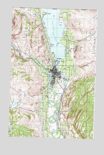
Oroville, WA USGS Topographic Map
Click on map above to begin viewing in our Map Viewer.

This topographic map contains these locations and features:
Feature Name Type Latitude Longitude GNIS ID View Map
Blue Diamond LakeLakeN48.9271°W119.3900°1516604View Map
Blue LakeLakeN48.9068°W119.4919°1516701View Map
Boundary PointCapeN48.9943°W119.4476°1516874View Map
City of OrovilleCivilN48.9367°W119.4340°2411338View Map
City of Oroville Fire DepartmentBuildingN48.9382°W119.4381°2606744View Map
Deep BayBayN48.9635°W119.4415°1528624View Map
Dorothy Scott AirportAirportN48.9590°W119.4120°1533872View Map
Driscoll IslandIslandN48.9132°W119.4312°1518921View Map
Eyhott IslandIslandN48.8946°W119.4359°1519424View Map
Faith Lutheran ChurchChurchN48.9348°W119.4378°2609747View Map
Grubbs CoveBayN48.9835°W119.4273°1520403View Map
Hot LakeLakeN48.9729°W119.4765°1520980View Map
Immaculate Conception ChurchChurchN48.9414°W119.4333°2609748View Map
Johnny Johnson LakeLakeN48.8818°W119.4964°1528789View Map
Kruger MountainSummitN48.9879°W119.4942°1521776View Map
Lake Osoyoos State ParkParkN48.9496°W119.4328°1529773View Map
Lake Osoyoos State ParkParkN48.9491°W119.4328°1521858View Map
Lehrman PondLakeN48.9571°W119.4182°1528877View Map
Mud LakeLakeN48.9144°W119.4778°1529142View Map
Ninemile CreekStreamN48.9704°W119.4265°1523672View Map
OK Copper MineMineN48.9929°W119.4823°1528626View Map
OrovillePopulated PlaceN48.9391°W119.4356°1524077View Map
Oroville - Osoyoos Port of EntryLocaleN48.9997°W119.4628°2608096View Map
Oroville AmbulanceBuildingN48.9380°W119.4376°2643543View Map
Oroville Assembly of God ChurchChurchN48.9390°W119.4334°2609750View Map
Oroville City HallBuildingN48.9385°W119.4378°2610580View Map
Oroville Community Bible ChurchChurchN48.9340°W119.4365°2609751View Map
Oroville Community LibraryBuildingN48.9375°W119.4372°2610142View Map
Oroville Elementary SchoolSchoolN48.9326°W119.4374°1530620View Map
Oroville Free Methodist ChurchChurchN48.9391°W119.4324°2609752View Map
Oroville Golf ClubLocaleN48.9534°W119.4789°2608359View Map
Oroville Middle - High SchoolSchoolN48.9345°W119.4390°1530621View Map
Oroville Police DepartmentBuildingN48.9383°W119.4380°2721961View Map
Oroville Post OfficePost OfficeN48.9376°W119.4392°2607000View Map
Oroville Sewage Treatment PlantLocaleN48.9245°W119.4395°2610709View Map
Oroville SubstationLocaleN48.9358°W119.4413°2606881View Map
Oroville Train Depot MuseumBuildingN48.9364°W119.4387°2610433View Map
Oroville United Methodist ChurchChurchN48.9337°W119.4347°2609753View Map
Osoyoos LakeLakeN48.9775°W119.4371°1524093View Map
Pentecostal Church of GodChurchN48.9349°W119.4347°2609754View Map
Pentland LakeLakeN48.8862°W119.4992°1529141View Map
Riverview CemeteryCemeteryN48.9190°W119.4462°1528858View Map
Rock LakeLakeN48.8775°W119.4818°1528788View Map
Scott Seaplane AnchorageAirportN48.9743°W119.4470°1534150View Map
Shady ParkParkN48.9646°W119.4403°1529438View Map
Silver Nail LakeLakeN48.9932°W119.4641°1525787View Map
Similkameen RiverStreamN48.8915°W119.4303°1525806View Map
Smith PointCapeN48.9666°W119.4295°1525987View Map
Smugglers SpringSpringN48.9927°W119.4840°1528625View Map
The Church of Jesus Christ of Latter Day SaintsChurchN48.9687°W119.4491°2609755View Map
Tomasket CreekStreamN48.9371°W119.4240°1534607View Map
Tonasket CreekStreamN48.9416°W119.4290°1528589View Map
Trinity Episcopal ChurchChurchN48.9383°W119.4331°2609756View Map
Valley Christian Fellowship ChurchChurchN48.9368°W119.4119°2609170View Map
Whistler CanyonValleyN48.8986°W119.4233°1528903View Map
Williams IslandIslandN48.9091°W119.4287°1528174View Map
Zosels Mill PondReservoirN48.9316°W119.4195°1532024View Map
Zosels Mill Pond DamDamN48.9316°W119.4195°1532023View Map

Note: Coordinates in the location and feature list above are referenced to NAD83 datum.


Copyright (C) 2008-2024 Ryan Niemi / Sunset Dynamics ... All Rights Reserved