TopoQuest Logo
Do you find TopoQuest useful?
Help keep TopoQuest running and adding new maps/features by donating!
Bitcoin:  19c7KJd3qBynnjoSw5npx9KScwjBe4ifkT
Litecoin:  LXs6TkuXGGXo1vDsWCkWVdjQX94eUKd6ui
Home View Maps Find Maps Find Places Resources & Links


Oldtown, Maryland Topographic Map

USGS Map Title: Oldtown, MD
USGS Map MRC: 39078E5
DRG (GeoTIFF) Download: o39078e5.tif


Neighboring USGS Topographic Map Quads:


  Evitts Creek, MD  
39078F6
 

  Flintstone, MD  
39078F5
 

  Artemas, PA  
39078F4
 

  Patterson Creek, WV  
39078E6
 

  Oldtown, MD  
39078E5
 

  Paw Paw, WV  
39078E4
 

  Springfield, WV  
39078D6
 

  Levels, WV  
39078D5
 

  Largent, WV  
39078D4


Map MRC Location:

N40°
W79°
N40°
W78°
H8 H7 H6 H5 H4 H3 H2 H1
G8 G7 G6 G5 G4 G3 G2 G1
F8 F7 F6 F5 F4 F3 F2 F1
E8 E7 E6 E5 E4 E3 E2 E1
D8 D7 D6 D5 D4 D3 D2 D1
C8 C7 C6 C5 C4 C3 C2 C1
B8 B7 B6 B5 B4 B3 B2 B1
A8 A7 A6 A5 A4 A3 A2 A1
N39°
W79°
N39°
W78°

Oldtown, MD USGS 1:24K Topographic Map Preview:
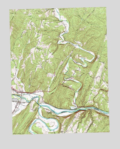
Oldtown, MD USGS Topographic Map
Click on map above to begin viewing in our Map Viewer.

This topographic map contains these locations and features:
Feature Name Type Latitude Longitude GNIS ID View Map
Big RunStreamN39.5237°W78.5328°583234View Map
Brights HollowValleyN39.5232°W78.5230°1536352View Map
District 2, OldtownCivilN39.5683°W78.5404°1929535View Map
Fifty-Four CemeteryCemeteryN39.5737°W78.5133°584373View Map
Gerlock HollowValleyN39.6131°W78.5605°584577View Map
Green SpringPopulated PlaceN39.5318°W78.6164°1539686View Map
Green SpringSpringN39.5281°W78.6050°1677920View Map
Green Spring Elementary School (historical)SchoolN39.5279°W78.6197°1718641View Map
Green Spring Post OfficePost OfficeN39.5299°W78.6189°1718642View Map
Green Spring RunStreamN39.5329°W78.6053°1539688View Map
Lock 67DamN39.5256°W78.5328°1713536View Map
Lock 68DamN39.5304°W78.5878°1713537View Map
Lock 69DamN39.5393°W78.6011°1713538View Map
Lock 70DamN39.5426°W78.6195°1713539View Map
Lock 71DamN39.5454°W78.6245°1713540View Map
Maple RunStreamN39.5829°W78.5308°585688View Map
Mill RunStreamN39.5351°W78.5989°585877View Map
Miller HollowValleyN39.5229°W78.5281°1543388View Map
Mount Olive ChurchChurchN39.5854°W78.5900°586018View Map
North Branch Potomac RiverStreamN39.5284°W78.5875°586218View Map
OkonokoPopulated PlaceN39.5231°W78.5253°1555261View Map
Okonoko ChurchChurchN39.5012°W78.5628°1544343View Map
OldtownPopulated PlaceN39.5415°W78.6114°591688View Map
Oldtown Baptist ChurchChurchN39.5418°W78.6122°1713546View Map
Oldtown Catholic CemeteryCemeteryN39.5445°W78.6145°1953208View Map
Oldtown Census Designated PlaceCensusN39.5428°W78.6155°2583668View Map
Oldtown K-12 SchoolSchoolN39.5412°W78.6086°1713547View Map
Oldtown Post OfficePost OfficeN39.5414°W78.6100°1713548View Map
Oldtown United Methodist CemeteryCemeteryN39.5443°W78.6136°1953209View Map
Oldtown Volunteer Fire DepartmentBuildingN39.5437°W78.6180°2085807View Map
Oldtown-Battie Mixon Picnic AreaLocaleN39.5429°W78.6195°1713549View Map
Paul Roeder Farm PondReservoirN39.5284°W78.5447°594497View Map
Paul Roeder Farm Pond DamDamN39.5284°W78.5447°594496View Map
Peters RunStreamN39.6212°W78.5617°586493View Map
PicardyPopulated PlaceN39.5390°W78.5133°1713552View Map
Pine RidgeRidgeN39.5883°W78.5906°586523View Map
Pumpkin CenterPopulated PlaceN39.6218°W78.5653°591082View Map
Railroad HollowValleyN39.6133°W78.5306°586768View Map
Russell RidgeRidgeN39.5126°W78.5456°1546190View Map
Sawpit RunStreamN39.5404°W78.5422°587235View Map
Seven Springs RunStreamN39.5406°W78.6053°587279View Map
South BranchLocaleN39.5223°W78.5742°1547063View Map
South Branch Potomac RiverStreamN39.5284°W78.5875°1552968View Map
Springfield Valley Volunteer Fire DepartmentBuildingN39.5270°W78.6214°2775490View Map
Stony RunStreamN39.5040°W78.5711°1547509View Map
Stratford RidgeRidgeN39.5600°W78.5626°587599View Map
Sugar HollowValleyN39.5999°W78.5589°587620View Map
Town CreekPopulated PlaceN39.5256°W78.5389°591418View Map
Town CreekStreamN39.5259°W78.5431°587847View Map
Town Creek AqueductBridgeN39.5231°W78.5442°1713559View Map
Town Creek Aqueduct CampgroundLocaleN39.5248°W78.5483°1713560View Map
Trading RunStreamN39.5584°W78.6178°587860View Map
Twigs HollowValleyN39.5402°W78.5003°587930View Map
Veterans of Foreign Wars Burial ParkCemeteryN39.5429°W78.6111°1953210View Map
Warrior MountainSummitN39.6210°W78.6203°588056View Map

Note: Coordinates in the location and feature list above are referenced to NAD83 datum.


Copyright (C) 2008-2024 Ryan Niemi / Sunset Dynamics ... All Rights Reserved