TopoQuest Logo
Do you find TopoQuest useful?
Help keep TopoQuest running and adding new maps/features by donating!
Bitcoin:  19c7KJd3qBynnjoSw5npx9KScwjBe4ifkT
Litecoin:  LXs6TkuXGGXo1vDsWCkWVdjQX94eUKd6ui
Home View Maps Find Maps Find Places Resources & Links


Old Rag Mountain, Virginia Topographic Map

USGS Map Title: Old Rag Mountain, VA
USGS Map MRC: 38078E3
DRG (GeoTIFF) Download: o38078e3.tif


Neighboring USGS Topographic Map Quads:


  Luray, VA  
38078F4
 

  Thornton Gap, VA  
38078F3
 

  Washington, VA  
38078F2
 

  Big Meadows, VA  
38078E4
 

  Old Rag Mountain, VA  
38078E3
 

  Woodville, VA  
38078E2
 

  Fletcher, VA  
38078D4
 

  Madison, VA  
38078D3
 

  Brightwood, VA  
38078D2


Map MRC Location:

N39°
W79°
N39°
W78°
H8 H7 H6 H5 H4 H3 H2 H1
G8 G7 G6 G5 G4 G3 G2 G1
F8 F7 F6 F5 F4 F3 F2 F1
E8 E7 E6 E5 E4 E3 E2 E1
D8 D7 D6 D5 D4 D3 D2 D1
C8 C7 C6 C5 C4 C3 C2 C1
B8 B7 B6 B5 B4 B3 B2 B1
A8 A7 A6 A5 A4 A3 A2 A1
N38°
W79°
N38°
W78°

Old Rag Mountain, VA USGS 1:24K Topographic Map Preview:
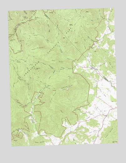
Old Rag Mountain, VA USGS Topographic Map
Click on map above to begin viewing in our Map Viewer.

This topographic map contains these locations and features:
Feature Name Type Latitude Longitude GNIS ID View Map
Aaron Nicholson House (historical)BuildingN38.6029°W78.3403°2705722View Map
Aarons BranchStreamN38.6029°W78.3400°1892148View Map
Adam Yowell MountainSummitN38.5016°W78.2567°1496781View Map
Berry HollowValleyN38.5397°W78.3475°1463108View Map
Bethlehem United Methodist ChurchChurchN38.5685°W78.2739°1463246View Map
Big TomSummitN38.5046°W78.3708°1463425View Map
Broad HollowValleyN38.6022°W78.2590°1463844View Map
Broad Hollow TrailTrailN38.6035°W78.2836°1463845View Map
Brokenback RunStreamN38.5737°W78.2942°1463873View Map
Browns MountainSummitN38.5765°W78.2567°1463929View Map
Buzzard RocksSummitN38.5196°W78.3601°1496825View Map
Byrds Nest Number 1LocaleN38.5501°W78.3206°1496827View Map
Camp Ridge TrailTrailN38.6132°W78.3389°1464346View Map
Catlett MountainSummitN38.6093°W78.3040°1496835View Map
Catlett Mountain TrailTrailN38.6151°W78.3017°1464544View Map
Cedar RunStreamN38.5398°W78.3500°1464649View Map
Cedar Run TrailTrailN38.5398°W78.3558°1464653View Map
Climbing Rose FallsFallsN38.5197°W78.3664°2705740View Map
Corbin CabinLocaleN38.6023°W78.3447°1465240View Map
Corbin Cabin TrailTrailN38.6096°W78.3461°1465241View Map
Corbin HollowValleyN38.5672°W78.3203°1465243View Map
Corbin MountainSummitN38.5795°W78.3336°1496858View Map
Corbin Mountain TrailTrailN38.5835°W78.3497°1465244View Map
Dale SpringSpringN38.6066°W78.3611°2705720View Map
Dulaney HollowValleyN38.5120°W78.2720°1466036View Map
Dulaney MountainSummitN38.5082°W78.2600°1497135View Map
EtlanPopulated PlaceN38.5254°W78.2625°1496887View Map
Etlan CemeteryCemeteryN38.5252°W78.2575°2053751View Map
Etlan Church (historical)ChurchN38.5032°W78.2769°2053748View Map
Etlan United Methodist ChurchChurchN38.5262°W78.2581°2053749View Map
Ferham School (historical)SchoolN38.5140°W78.3631°1494583View Map
Gibson HollowValleyN38.5162°W78.3028°1467070View Map
Graves MountainSummitN38.5029°W78.3472°1497136View Map
Halfmile CliffCliffN38.5396°W78.3619°1467656View Map
Hannah RunStreamN38.5885°W78.3136°1467712View Map
Hannah Run TrailTrailN38.6135°W78.3175°1467713View Map
Hazel MountainSummitN38.6217°W78.2850°1496939View Map
Hazel School (historical)SchoolN38.6168°W78.2875°1673965View Map
Hemlock Springs OverlookLocaleN38.5971°W78.3628°1467913View Map
Hot MountainSummitN38.5938°W78.2986°1496948View Map
Hot Short Mountain TrailTrailN38.5968°W78.3056°1468322View Map
Hughes River Church (historical)ChurchN38.5918°W78.3161°1494587View Map
Hughes River GapGapN38.6121°W78.3572°1468362View Map
Indian Run TrailTrailN38.5957°W78.3525°1468489View Map
Lindsay MountainSummitN38.5759°W78.3085°2705723View Map
Little Stony ManSummitN38.6029°W78.3678°1496994View Map
NethersPopulated PlaceN38.5704°W78.2778°1495996View Map
Nethers Mill Lighthouse TabernacleChurchN38.5686°W78.2748°2705759View Map
Nicholson HollowValleyN38.5738°W78.2968°1471539View Map
Nicholson Hollow TrailTrailN38.5951°W78.3261°1471540View Map
Old Rag MountainSummitN38.5517°W78.3160°1471867View Map
Old Rag ShelterLocaleN38.5537°W78.3294°1471868View Map
OldragPopulated PlaceN38.5571°W78.3331°1848400View Map
Oldrag (historical)Populated PlaceN38.5571°W78.3322°1494596View Map
Oldrag Post OfficePost OfficeN38.5571°W78.3331°1848401View Map
Piedmont ChurchChurchN38.6048°W78.2500°1472279View Map
Pine HillSummitN38.5851°W78.2719°1472355View Map
Pine Hill GapGapN38.5887°W78.2781°1472360View Map
Pine Hill Gap TrailTrailN38.5979°W78.2864°1472361View Map
Pinnacle OverlookLocaleN38.6223°W78.3231°1472419View Map
Pinnacle PeakSummitN38.5896°W78.3397°1502804View Map
Pinnacle RidgeRidgeN38.6134°W78.3283°1472422View Map
Pinnacle Ridge TrailTrailN38.6140°W78.3278°1472423View Map
Pinnacles Picnic GroundsLocaleN38.6240°W78.3435°1472420View Map
Pleasant Grove Church (historical)ChurchN38.5079°W78.2739°1494598View Map
Ragged RunStreamN38.5296°W78.2686°1472939View Map
Ridge TrailTrailN38.5590°W78.3050°1473205View Map
Robertson MountainSummitN38.5701°W78.3422°1473322View Map
Robertson Mountain TrailTrailN38.5682°W78.3381°1473323View Map
Rocky RunStreamN38.5712°W78.2800°1473488View Map
Saddle TrailTrailN38.5518°W78.3256°1473683View Map
Sams Ridge TrailTrailN38.6104°W78.2728°1473986View Map
Sams RunStreamN38.6154°W78.2644°1473987View Map
Sexton Shelter (historical)LocaleN38.6207°W78.3433°1494604View Map
Shaver Hollow Shelter (historical)LocaleN38.6176°W78.3533°1474458View Map
Shenandoah Research and Resource Management CenterLocaleN38.6179°W78.3428°1472421View Map
Short MountainSummitN38.6007°W78.3094°1474554View Map
Stony ManSummitN38.5982°W78.3733°1475210View Map
Stony Man OverlookLocaleN38.6110°W78.3625°1496268View Map
The IslandLocaleN38.5389°W78.3475°2705760View Map
Thorofare MountainSummitN38.5896°W78.3397°1502811View Map
Thorofare Mountain OverlookLocaleN38.5876°W78.3597°1496201View Map
Thorofare Mountain School (historical)SchoolN38.5835°W78.3500°1494608View Map
Tims RiverStreamN38.5553°W78.3521°1471371View Map
Weakley HollowValleyN38.5730°W78.2956°1476408View Map
White Oak Ranger StationLocaleN38.5785°W78.3653°1476615View Map
Whiteoak CanyonValleyN38.5394°W78.3477°1476658View Map

Note: Coordinates in the location and feature list above are referenced to NAD83 datum.


Copyright (C) 2008-2024 Ryan Niemi / Sunset Dynamics ... All Rights Reserved