TopoQuest Logo
Do you find TopoQuest useful?
Help keep TopoQuest running and adding new maps/features by donating!
Bitcoin:  19c7KJd3qBynnjoSw5npx9KScwjBe4ifkT
Litecoin:  LXs6TkuXGGXo1vDsWCkWVdjQX94eUKd6ui
Home View Maps Find Maps Find Places Resources & Links


Odessa, Florida Topographic Map

USGS Map Title: Odessa, FL
USGS Map MRC: 28082B5
DRG (GeoTIFF) Download: o28082b5.tif


Neighboring USGS Topographic Map Quads:


  Port Richey, FL  
28082C6
 

  Fivay Junction, FL  
28082C5
 

  Ehren, FL  
28082C4
 

  Elfers, FL  
28082B6
 

  Odessa, FL  
28082B5
 

  Lutz, FL  
28082B4
 

  Oldsmar, FL  
28082A6
 

  Citrus Park, FL  
28082A5
 

  Sulphur Springs, FL  
28082A4


Map MRC Location:

N29°
W83°
N29°
W82°
H8 H7 H6 H5 H4 H3 H2 H1
G8 G7 G6 G5 G4 G3 G2 G1
F8 F7 F6 F5 F4 F3 F2 F1
E8 E7 E6 E5 E4 E3 E2 E1
D8 D7 D6 D5 D4 D3 D2 D1
C8 C7 C6 C5 C4 C3 C2 C1
B8 B7 B6 B5 B4 B3 B2 B1
A8 A7 A6 A5 A4 A3 A2 A1
N28°
W83°
N28°
W82°

Odessa, FL USGS 1:24K Topographic Map Preview:
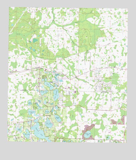
Odessa, FL USGS Topographic Map
Click on map above to begin viewing in our Map Viewer.

This topographic map contains these locations and features:
Feature Name Type Latitude Longitude GNIS ID View Map
AlldredgePopulated PlaceN28.1614°W82.5682°2482168View Map
Anderson LakeLakeN28.2181°W82.6019°277859View Map
Angel Farms EstatesPopulated PlaceN28.1664°W82.5565°2482203View Map
Austin Davis Public LibraryBuildingN28.1347°W82.5765°2481132View Map
Bayonnes at ChevalPopulated PlaceN28.1541°W82.5081°2481538View Map
Beau RivagePopulated PlaceN28.1538°W82.5119°2481571View Map
Belmack AcresPopulated PlaceN28.1334°W82.6225°2481592View Map
Biarritz VillagePopulated PlaceN28.1479°W82.5148°2481621View Map
Black LakeLakeN28.1908°W82.5766°278902View Map
C And B EstatesPopulated PlaceN28.1280°W82.5944°2482672View Map
Calusa TracePopulated PlaceN28.1310°W82.5140°2482682View Map
Camp KeystoneLocaleN28.1614°W82.5965°279912View Map
Camp MawainLocaleN28.1439°W82.5684°300084View Map
Camp Singing PinesLocaleN28.1572°W82.5934°279935View Map
Cannes VillagePopulated PlaceN28.1518°W82.5104°2482708View Map
Canterbury WoodsPopulated PlaceN28.1260°W82.5742°2482717View Map
Chateaux LoirePopulated PlaceN28.1483°W82.5065°2482814View Map
ChevalPopulated PlaceN28.1486°W82.5145°1853241View Map
Cheval Boulevard Estates EastPopulated PlaceN28.1489°W82.5176°2482824View Map
Cheval Boulevard Estates WestPopulated PlaceN28.1500°W82.5175°2482825View Map
Cheval Census Designated PlaceCensusN28.1459°W82.5185°2402769View Map
Cheval East BordeauxPopulated PlaceN28.1528°W82.5171°2482826View Map
Cheval Lake Club VillasPopulated PlaceN28.1524°W82.5081°2482827View Map
Cheval Polo And Golf ClubLocaleN28.1447°W82.5218°2481967View Map
Cheval Wimbledon VillagePopulated PlaceN28.1473°W82.5049°2482828View Map
Cimino EstatesPopulated PlaceN28.1260°W82.5768°2482835View Map
ClarkmerePopulated PlaceN28.1269°W82.5779°2482853View Map
Council CrestPopulated PlaceN28.1492°W82.5989°2482921View Map
Crescent LakeLakeN28.1581°W82.5922°281034View Map
CrippenwoodPopulated PlaceN28.1603°W82.5775°2482975View Map
Cross Cypress BranchStreamN28.2364°W82.5790°281098View Map
Cypress LakeLakeN28.1255°W82.5647°277633View Map
Cypress Lake EstatesPopulated PlaceN28.1271°W82.5660°2482246View Map
DalyPopulated PlaceN28.1282°W82.5806°2482258View Map
Estates of Lake AlicePopulated PlaceN28.1333°W82.6103°2482452View Map
Fern GlenPopulated PlaceN28.1566°W82.5209°2482507View Map
Great LakesPopulated PlaceN28.1707°W82.5783°2483330View Map
Gulf PinePopulated PlaceN28.1739°W82.5909°300902View Map
Heritage HarborPopulated PlaceN28.1651°W82.5051°2483454View Map
Heritage Harbor VillagePopulated PlaceN28.1579°W82.5029°2483455View Map
Hillsborough County Fire and Rescue Station 34BuildingN28.1288°W82.5461°2131675View Map
Island Ford LakeLakeN28.1523°W82.5989°284612View Map
Island Ford Lake BeachPopulated PlaceN28.1547°W82.5974°2483613View Map
KeystonePopulated PlaceN28.1558°W82.6212°300080View Map
Keystone BeachPopulated PlaceN28.1323°W82.5855°2483694View Map
Keystone Census Designated PlaceCensusN28.1312°W82.5999°2403173View Map
Keystone ChurchChurchN28.1292°W82.5665°285086View Map
Keystone CovePopulated PlaceN28.1421°W82.5976°2483695View Map
Keystone EstatesPopulated PlaceN28.1411°W82.5970°2483697View Map
Keystone FarmsPopulated PlaceN28.1275°W82.5967°2483698View Map
Keystone Grove LakesPopulated PlaceN28.1413°W82.6026°2483699View Map
Keystone LakeLakeN28.1331°W82.5901°285091View Map
Keystone Lake View ParkPopulated PlaceN28.1404°W82.5891°2483702View Map
Keystone ManorPopulated PlaceN28.1447°W82.5977°2483703View Map
Keystone ParkParkN28.1333°W82.5762°285092View Map
Keystone Park ColonyPopulated PlaceN28.1493°W82.6010°2483706View Map
Keystone ReservePopulated PlaceN28.1465°W82.5896°2483707View Map
Keystone ShoresPopulated PlaceN28.1373°W82.6004°2483708View Map
Keystone TerracePopulated PlaceN28.1343°W82.5788°2483710View Map
Lady Lake EstatesPopulated PlaceN28.1555°W82.5699°2483763View Map
Lake AbrayPopulated PlaceN28.1476°W82.6045°2483767View Map
Lake AliceLakeN28.1323°W82.6042°277746View Map
Lake Alice EstatesPopulated PlaceN28.1302°W82.6018°2483768View Map
Lake AnnLakeN28.1779°W82.5817°277887View Map
Lake ArtilleryLakeN28.1624°W82.5856°277963View Map
Lake CalmPopulated PlaceN28.1395°W82.5849°2483774View Map
Lake CalmLakeN28.1423°W82.5817°279847View Map
Lake Calm EstatesPopulated PlaceN28.1485°W82.5817°2483775View Map
Lake ElizabethLakeN28.1575°W82.5735°282162View Map
Lake FernPopulated PlaceN28.1497°W82.5795°294829View Map
Lake FernLakeN28.1534°W82.5835°282432View Map
Lake FrancesLakeN28.1615°W82.6018°282779View Map
Lake GenevaLakeN28.1880°W82.5731°283015View Map
Lake HiawathaLakeN28.1695°W82.5743°283935View Map
Lake MinniolaLakeN28.1847°W82.5743°286965View Map
Lake SeminoleLakeN28.1780°W82.5745°290848View Map
Lake TaylorLakeN28.1367°W82.6121°292079View Map
Lake WastenaLakeN28.1632°W82.5915°292915View Map
Lake WoodLakeN28.1551°W82.5776°293493View Map
Lakes of KeystonePopulated PlaceN28.1342°W82.5839°2483838View Map
Lakeview at Calusa TracePopulated PlaceN28.1353°W82.5062°2483845View Map
LindawoodsPopulated PlaceN28.1344°W82.5805°2483049View Map
MontreuxPopulated PlaceN28.1534°W82.5637°2484312View Map
Mound LakeLakeN28.1475°W82.5720°287192View Map
OdessaPopulated PlaceN28.1939°W82.5918°288053View Map
Odessa Census Designated PlaceCensusN28.1820°W82.5530°2403369View Map
Odessa ChurchChurchN28.1770°W82.5912°288054View Map
Odessa Post OfficePost OfficeN28.1745°W82.5955°2768007View Map
Odessa WoodsPopulated PlaceN28.1700°W82.5546°2484492View Map
Osceola LakeLakeN28.1714°W82.5871°288266View Map
Pasco County Fire Rescue Station 15BuildingN28.1869°W82.6241°2131527View Map
Pasco County Fire Rescue Station 37BuildingN28.1943°W82.5066°2644388View Map
Pasco County Sheriff's Office District 3 Trinity Operations CenterBuildingN28.1869°W82.6240°2756074View Map
Pasco PlazaLocaleN28.1567°W82.5807°296496View Map
Post ShoresPopulated PlaceN28.1256°W82.5909°2483934View Map
Rankin AcresPopulated PlaceN28.1254°W82.5271°2483985View Map
ReflectionsPopulated PlaceN28.1377°W82.5231°2483998View Map
RidgelandPopulated PlaceN28.1689°W82.5783°2484028View Map
Sandy BranchStreamN28.2331°W82.5684°290609View Map
ShapiroPopulated PlaceN28.1605°W82.5749°2484923View Map
South Branch Anclote RiverStreamN28.2222°W82.6093°291349View Map
StillwaterPopulated PlaceN28.1512°W82.5710°2485051View Map
Swan CovePopulated PlaceN28.1466°W82.6060°2485142View Map
The Cove at Lake AlicePopulated PlaceN28.1382°W82.6060°2485238View Map
The Meadows at Van Dyke FarmsPopulated PlaceN28.1268°W82.5568°2485259View Map
The NestPopulated PlaceN28.1387°W82.6111°2485260View Map
TrezevantPopulated PlaceN28.1318°W82.6019°2485331View Map
Turkey Ford LakeLakeN28.1328°W82.5406°292525View Map
Van Dyke CommonsPopulated PlaceN28.1250°W82.5009°2485401View Map
Van Dyke EstatesPopulated PlaceN28.1268°W82.5200°2485402View Map
Van Dyke LakeLakeN28.1300°W82.5186°292731View Map
WTKN-AM (Pinellas Park)TowerN28.2114°W82.5293°310121View Map
Wyndham LakesPopulated PlaceN28.1713°W82.5819°2484820View Map
Zambito EstatesPopulated PlaceN28.1345°W82.5515°2484832View Map

Note: Coordinates in the location and feature list above are referenced to NAD83 datum.


Copyright (C) 2008-2024 Ryan Niemi / Sunset Dynamics ... All Rights Reserved