TopoQuest Logo
Do you find TopoQuest useful?
Help keep TopoQuest running and adding new maps/features by donating!
Bitcoin:  19c7KJd3qBynnjoSw5npx9KScwjBe4ifkT
Litecoin:  LXs6TkuXGGXo1vDsWCkWVdjQX94eUKd6ui
Home View Maps Find Maps Find Places Resources & Links


Oak City North, Utah Topographic Map

USGS Map Title: Oak City North, UT
USGS Map MRC: 39112D3
DRG (GeoTIFF) Download: o39112d3.tif


Neighboring USGS Topographic Map Quads:


  Lynndyl West, UT  
39112E4
 

  Lynndyl East, UT  
39112E3
 

  Champlin Peak, UT  
39112E2
 

  Strong, UT  
39112D4
 

  Oak City North, UT  
39112D3
 

  Fool Creek Peak, UT  
39112D2
 

  Harding, UT  
39112C4
 

  Oak City South, UT  
39112C3
 

  Williams Peak, UT  
39112C2


Map MRC Location:

N40°
W113°
N40°
W112°
H8 H7 H6 H5 H4 H3 H2 H1
G8 G7 G6 G5 G4 G3 G2 G1
F8 F7 F6 F5 F4 F3 F2 F1
E8 E7 E6 E5 E4 E3 E2 E1
D8 D7 D6 D5 D4 D3 D2 D1
C8 C7 C6 C5 C4 C3 C2 C1
B8 B7 B6 B5 B4 B3 B2 B1
A8 A7 A6 A5 A4 A3 A2 A1
N39°
W113°
N39°
W112°

Oak City North, UT USGS 1:24K Topographic Map Preview:
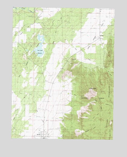
Oak City North, UT USGS Topographic Map
Click on map above to begin viewing in our Map Viewer.

This topographic map contains these locations and features:
Feature Name Type Latitude Longitude GNIS ID View Map
Box CanyonValleyN39.4369°W112.2705°1439058View Map
Bridge CanyonValleyN39.4105°W112.2894°1439094View Map
Devils TwistCliffN39.3991°W112.2738°1440439View Map
Fool CreekLocaleN39.4716°W112.2691°1448410View Map
Fool CreekStreamN39.4700°W112.3244°1441154View Map
Fool Creek FlatFlatN39.4719°W112.2766°1435540View Map
Fool Creek Number One DamDamN39.4516°W112.3513°1447793View Map
Fool Creek Number Two DamDamN39.4500°W112.3708°1447795View Map
Fool Creek Number Two ReservoirReservoirN39.4500°W112.3708°1447794View Map
Fool Creek PointRidgeN39.4508°W112.3030°1448411View Map
Fool Creek Reservoir Number 1ReservoirN39.4513°W112.3513°1454431View Map
Horse HollowValleyN39.4205°W112.3147°1441881View Map
Little Wild Horse CanyonValleyN39.4863°W112.2541°1448614View Map
Mahogany HollowValleyN39.3847°W112.3152°1443087View Map
Oak City Fire DepartmentBuildingN39.3752°W112.3373°2627400View Map
Oak City Post OfficePost OfficeN39.3765°W112.3357°2769033View Map
Oak CreekStreamN39.4197°W112.3508°1444016View Map
Pauls MeadowAreaN39.3902°W112.2549°1444747View Map
Pole CanyonValleyN39.4433°W112.2627°1444529View Map
Taylors FlatFlatN39.4797°W112.3647°1446358View Map
The Church of Jesus Christ of Latter Day SaintsChurchN39.3755°W112.3352°1449575View Map
Town of Oak CityCivilN39.3761°W112.3390°2413060View Map

Note: Coordinates in the location and feature list above are referenced to NAD83 datum.


Copyright (C) 2008-2024 Ryan Niemi / Sunset Dynamics ... All Rights Reserved