TopoQuest Logo
Do you find TopoQuest useful?
Help keep TopoQuest running and adding new maps/features by donating!
Bitcoin:  19c7KJd3qBynnjoSw5npx9KScwjBe4ifkT
Litecoin:  LXs6TkuXGGXo1vDsWCkWVdjQX94eUKd6ui
Home View Maps Find Maps Find Places Resources & Links


Northville, New York Topographic Map

USGS Map Title: Northville, NY
USGS Map MRC: 43074B2
DRG (GeoTIFF) Download: o43074b2.tif


Neighboring USGS Topographic Map Quads:


  Jackson Summit, NY  
43074B3
 

  Northville, NY  
43074B2
 

  Edinburg, NY  
43074B1
 

  Gloversville, NY  
43074A3
 

  Broadalbin, NY  
43074A2
 

  Galway, NY  
43074A1


Map MRC Location:

N44°
W75°
N44°
W74°
H8 H7 H6 H5 H4 H3 H2 H1
G8 G7 G6 G5 G4 G3 G2 G1
F8 F7 F6 F5 F4 F3 F2 F1
E8 E7 E6 E5 E4 E3 E2 E1
D8 D7 D6 D5 D4 D3 D2 D1
C8 C7 C6 C5 C4 C3 C2 C1
B8 B7 B6 B5 B4 B3 B2 B1
A8 A7 A6 A5 A4 A3 A2 A1
N43°
W75°
N43°
W74°

Northville, NY USGS 1:24K Topographic Map Preview:
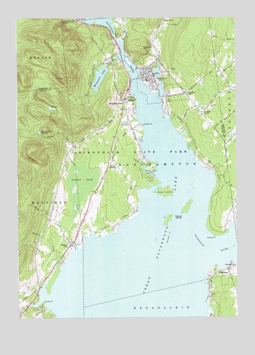
Northville, NY USGS Topographic Map
Click on map above to begin viewing in our Map Viewer.

This topographic map contains these locations and features:
Feature Name Type Latitude Longitude GNIS ID View Map
Baptist Church of NorthvilleChurchN43.2263°W74.1740°2615562View Map
Birch Haven CampgroundLocaleN43.1365°W74.1380°2615185View Map
Carpenters CornersPopulated PlaceN43.2187°W74.1540°945894View Map
Christie CemeteryCemeteryN43.1356°W74.2455°946639View Map
Cranberry CreekPopulated PlaceN43.1556°W74.2196°947654View Map
Edinburg Common SchoolSchoolN43.2208°W74.1256°2438475View Map
Fairchilds CornersLocaleN43.2106°W74.1449°949807View Map
First United Methodist Church of NorthvilleChurchN43.2232°W74.1710°2616024View Map
Fish HousePopulated PlaceN43.1445°W74.1329°950143View Map
Gifford ValleyValleyN43.2342°W74.1926°951085View Map
Gifford Valley CemeteryCemeteryN43.2320°W74.1972°951086View Map
Great Sacandaga LakeReservoirN43.1417°W74.1776°973352View Map
Hampton PointCapeN43.2053°W74.1782°952146View Map
Heyday Mobile Home ParkPopulated PlaceN43.1560°W74.2212°2618234View Map
Hunters CreekStreamN43.2315°W74.1690°970227View Map
Jackson CreekStreamN43.1459°W74.2262°953882View Map
Kenyon IslandsIslandN43.1709°W74.1532°954543View Map
Lake View OrchardsLocaleN43.1392°W74.2411°2556783View Map
Lakeside Mobile EstatesPopulated PlaceN43.1958°W74.1806°2618247View Map
Mead IslandIslandN43.1776°W74.1660°956863View Map
Mud LakeLakeN43.2130°W74.2311°958030View Map
Northampton Ambulance ServiceBuildingN43.2246°W74.1736°2720208View Map
Northampton Beach CampsiteLocaleN43.1834°W74.1743°958955View Map
Northampton Town OfficeBuildingN43.2215°W74.1693°2617551View Map
Northampton United Methodist ChurchChurchN43.1466°W74.1262°958954View Map
NorthvillePopulated PlaceN43.2256°W74.1721°958987View Map
Northville Elementary SchoolSchoolN43.2250°W74.1763°2668885View Map
Northville Fire DepartmentBuildingN43.2254°W74.1714°2718407View Map
Northville High SchoolSchoolN43.2243°W74.1758°2669233View Map
Northville Main Street CemeteryCemeteryN43.2232°W74.1692°2371790View Map
Northville Presbyterian ChurchChurchN43.2291°W74.1749°2616161View Map
Osbourne BridgeLocaleN43.1806°W74.1510°975760View Map
Paradise PointCapeN43.1309°W74.2357°959845View Map
Prospect HillSummitN43.2373°W74.1787°961175View Map
Prospect Hill CemeteryCemeteryN43.2322°W74.1733°2371791View Map
Sacandaga Golf ClubLocaleN43.2123°W74.1858°2615469View Map
Sacandaga ParkPopulated PlaceN43.2162°W74.1893°963160View Map
Sacandaga Park ReservoirReservoirN43.2024°W74.2372°963163View Map
Saint Francis ChurchChurchN43.2255°W74.1773°2616907View Map
Sinclaire PointCapeN43.1592°W74.1374°965302View Map
Sweets CrossingPopulated PlaceN43.1881°W74.1987°966927View Map
Tamarack SwampSwampN43.1823°W74.2135°967024View Map
Town of NorthamptonCivilN43.1934°W74.1747°979281View Map
Village of NorthvilleCivilN43.2239°W74.1703°2391027View Map
Woodward LakeLakeN43.2254°W74.2025°971729View Map

Note: Coordinates in the location and feature list above are referenced to NAD83 datum.


Copyright (C) 2008-2024 Ryan Niemi / Sunset Dynamics ... All Rights Reserved