TopoQuest Logo
Do you find TopoQuest useful?
Help keep TopoQuest running and adding new maps/features by donating!
Bitcoin:  19c7KJd3qBynnjoSw5npx9KScwjBe4ifkT
Litecoin:  LXs6TkuXGGXo1vDsWCkWVdjQX94eUKd6ui
Home View Maps Find Maps Find Places Resources & Links


Newfound Lake, New Hampshire Topographic Map

USGS Map Title: Newfound Lake, NH
USGS Map MRC: 43071F7
DRG (GeoTIFF) Download: o43071f7.tif


Neighboring USGS Topographic Map Quads:


  Wentworth, NH  
43071G8
 

  Rumney, NH  
43071G7
 

  Plymouth, NH  
43071G6
 

  Mount Cardigan, NH  
43071F8
 

  Newfound Lake, NH  
43071F7
 

  Ashland, NH  
43071F6
 

  Grafton, NH  
43071E8
 

  Danbury, NH  
43071E7
 

  Bristol, NH  
43071E6


Map MRC Location:

N44°
W72°
N44°
W71°
H8 H7 H6 H5 H4 H3 H2 H1
G8 G7 G6 G5 G4 G3 G2 G1
F8 F7 F6 F5 F4 F3 F2 F1
E8 E7 E6 E5 E4 E3 E2 E1
D8 D7 D6 D5 D4 D3 D2 D1
C8 C7 C6 C5 C4 C3 C2 C1
B8 B7 B6 B5 B4 B3 B2 B1
A8 A7 A6 A5 A4 A3 A2 A1
N43°
W72°
N43°
W71°

Newfound Lake, NH USGS 1:24K Topographic Map Preview:
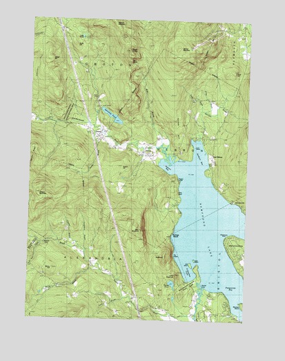
Newfound Lake, NH USGS Topographic Map
Click on map above to begin viewing in our Map Viewer.

This topographic map contains these locations and features:
Feature Name Type Latitude Longitude GNIS ID View Map
Bailey BrookStreamN43.6498°W71.8729°865326View Map
Bailey HillSummitN43.6459°W71.8609°865328View Map
Bald KnobSummitN43.7331°W71.8170°865350View Map
Bear MountainSummitN43.6637°W71.8098°865454View Map
Belle IslandIslandN43.6509°W71.7795°865534View Map
Black BrookStreamN43.6281°W71.7562°865618View Map
Bog BrookStreamN43.6384°W71.7734°865697View Map
Brock BrookStreamN43.6456°W71.8320°865805View Map
Camp BereaLocaleN43.6715°W71.7862°865922View Map
Camp PasquaneyLocaleN43.6829°W71.7642°865949View Map
Chesley BrookStreamN43.6556°W71.8454°866138View Map
Cilley BrookStreamN43.7126°W71.7742°866166View Map
Clark BrookStreamN43.6456°W71.8320°866176View Map
Cockermouth RiverStreamN43.6929°W71.7937°866238View Map
East HebronPopulated PlaceN43.6934°W71.7695°866708View Map
East Hebron Post OfficePost OfficeN43.6915°W71.7695°1916525View Map
Fretts BrookStreamN43.7126°W71.7765°866986View Map
Georges BrookStreamN43.7012°W71.7773°867045View Map
Goose PondLakeN43.6403°W71.7910°867123View Map
GrotonPopulated PlaceN43.7017°W71.8356°867264View Map
Groton Police DeptBuildingN43.7459°W71.8574°2752826View Map
Groton School CampLocaleN43.6304°W71.7570°867265View Map
Hardy BrookStreamN43.7045°W71.8373°867372View Map
HebronPopulated PlaceN43.6940°W71.8056°867438View Map
Hebron BayBayN43.6898°W71.7931°867439View Map
Hebron Fire DepartmentBuildingN43.6945°W71.8106°2605217View Map
Hebron Police DepartmentBuildingN43.6945°W71.8104°2752857View Map
Hebron Post OfficePost OfficeN43.6945°W71.8064°1916589View Map
Hebron Public LibraryBuildingN43.6956°W71.8048°1916590View Map
Hebron Village CemeteryCemeteryN43.6949°W71.8054°1916591View Map
Hebron Village Historic DistrictParkN43.6940°W71.8095°1916592View Map
Hebron Village SchoolSchoolN43.6937°W71.8056°1916593View Map
Hobart HillSummitN43.6884°W71.8231°867521View Map
Hornet CoveBayN43.6406°W71.7751°867604View Map
Hoyt HillSummitN43.7281°W71.7601°867650View Map
Jewell HillSummitN43.7334°W71.8654°867778View Map
Little PondLakeN43.7428°W71.8454°868078View Map
Little SugarloafSummitN43.6448°W71.7892°868095View Map
Loon IslandIslandN43.6970°W71.7792°868160View Map
Melton Falls TrailTrailN43.6742°W71.8292°868368View Map
Mount CrosbySummitN43.7376°W71.8187°866411View Map
Newfound LakeLakeN43.6603°W71.7681°868726View Map
Nuttings BeachPopulated PlaceN43.6626°W71.7901°868862View Map
Oregon MountainSummitN43.6770°W71.8704°868924View Map
Pasquaney BayBayN43.6390°W71.7540°869015View Map
Pratt CemeteryCemeteryN43.6967°W71.8277°869341View Map
Red SchoolSchoolN43.6398°W71.8579°869470View Map
Riverside CemeteryCemeteryN43.6360°W71.8156°869516View Map
Riverside SchoolSchoolN43.6512°W71.8415°869518View Map
Rogers LedgeBenchN43.6837°W71.7884°869582View Map
Rolfe HillSummitN43.7401°W71.8487°869586View Map
Sanborn BayBayN43.6920°W71.7776°869758View Map
School Number 9SchoolN43.7059°W71.8467°873274View Map
Sculptured RocksPillarN43.7073°W71.8556°869827View Map
Sculptured Rocks State Wayside AreaLocaleN43.7126°W71.8551°1916813View Map
Spectacle PondReservoirN43.7097°W71.8276°870082View Map
Spectacle Pond DamDamN43.7134°W71.8345°1774829View Map
SugarloafSummitN43.6520°W71.7956°870263View Map
Templeton BrookStreamN43.6542°W71.8423°870355View Map
Tenney HillRidgeN43.7051°W71.7898°870359View Map
Tenney MountainSummitN43.7359°W71.7934°870360View Map
Town BrookStreamN43.6356°W71.8192°870474View Map
Town of GrotonCivilN43.7451°W71.8600°873614View Map
Town of HebronCivilN43.6948°W71.7921°873622View Map
Turnpike SchoolSchoolN43.7487°W71.7526°870543View Map
Union Congregational ChurchChurchN43.6945°W71.8059°1916870View Map
Wellington State ParkParkN43.6437°W71.7767°870723View Map
Welton FallsFallsN43.6529°W71.8501°870729View Map
Welton Falls State ForestForestN43.6570°W71.8704°1918015View Map
Whittemore PointCapeN43.6612°W71.7601°870875View Map
Wise BrookStreamN43.6979°W71.7984°870964View Map

Note: Coordinates in the location and feature list above are referenced to NAD83 datum.


Copyright (C) 2008-2024 Ryan Niemi / Sunset Dynamics ... All Rights Reserved