TopoQuest Logo
Do you find TopoQuest useful?
Help keep TopoQuest running and adding new maps/features by donating!
Bitcoin:  19c7KJd3qBynnjoSw5npx9KScwjBe4ifkT
Litecoin:  LXs6TkuXGGXo1vDsWCkWVdjQX94eUKd6ui
Home View Maps Find Maps Find Places Resources & Links


Naturita, Colorado Topographic Map

USGS Map Title: Naturita, CO
USGS Map MRC: 38108B5
DRG (GeoTIFF) Download: o38108b5.tif


Neighboring USGS Topographic Map Quads:


  Uravan, CO  
38108C6
 

  Nucla, CO  
38108C5
 

  Big Bucktail Creek, CO  
38108C4
 

  Naturita NW, CO  
38108B6
 

  Naturita, CO  
38108B5
 

  Redvale, CO  
38108B4
 

  Gypsum Gap, CO  
38108A6
 

  Basin, CO  
38108A5
 

  Barkelew Draw, CO  
38108A4


Map MRC Location:

N39°
W109°
N39°
W108°
H8 H7 H6 H5 H4 H3 H2 H1
G8 G7 G6 G5 G4 G3 G2 G1
F8 F7 F6 F5 F4 F3 F2 F1
E8 E7 E6 E5 E4 E3 E2 E1
D8 D7 D6 D5 D4 D3 D2 D1
C8 C7 C6 C5 C4 C3 C2 C1
B8 B7 B6 B5 B4 B3 B2 B1
A8 A7 A6 A5 A4 A3 A2 A1
N38°
W109°
N38°
W108°

Naturita, CO USGS 1:24K Topographic Map Preview:
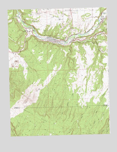
Naturita, CO USGS Topographic Map
Click on map above to begin viewing in our Map Viewer.

This topographic map contains these locations and features:
Feature Name Type Latitude Longitude GNIS ID View Map
Annie MineMineN38.2294°W108.5159°1745364View Map
April MineMineN38.2172°W108.5676°1735511View Map
Bay State MineMineN38.2172°W108.5676°1735513View Map
BCD DitchCanalN38.2172°W108.5423°186028View Map
Bramiers DrawValleyN38.2144°W108.5481°186020View Map
Broad CanyonValleyN38.2191°W108.5203°186033View Map
Brooks BridgeBridgeN38.2442°W108.5018°186025View Map
Cummings MineMineN38.2172°W108.5676°1735526View Map
Dry CreekStreamN38.2314°W108.6006°186022View Map
East VancorumPopulated PlaceN38.2278°W108.5951°186023View Map
Emma MineMineN38.2253°W108.5273°1745365View Map
Fiddling Bill MineMineN38.2403°W108.6034°1745366View Map
First ParkFlatN38.2472°W108.5506°203173View Map
Hamilton CreekStreamN38.2192°W108.5204°176345View Map
Hopkins FieldAirportN38.2408°W108.5633°186024View Map
Lexington MineMineN38.2211°W108.5720°1745352View Map
Long DrawValleyN38.2053°W108.5075°186018View Map
Mary Ann MineMineN38.2267°W108.5101°1745367View Map
Maverick DrawValleyN38.2246°W108.5077°186038View Map
Montrose County Deputy Sheriff's OfficeBuildingN38.2411°W108.5625°2757265View Map
NaturitaPopulated PlaceN38.2183°W108.5687°186027View Map
Naturita CanyonValleyN38.2178°W108.5467°186053View Map
Naturita CreekStreamN38.2186°W108.5490°186061View Map
Naturita Post OfficePost OfficeN38.2172°W108.5712°2750967View Map
Naturita RidgeRidgeN38.1442°W108.5906°186019View Map
Nucla - Naturita Fire Department Station 2BuildingN38.2158°W108.5624°2666932View Map
Philadelphia MineMineN38.2253°W108.5273°1745368View Map
Reed-Chatfield DitchCanalN38.2239°W108.5381°186026View Map
Republican MineMineN38.2172°W108.5676°1735559View Map
Rose MineMineN38.2258°W108.5104°1745369View Map
San Miguel CanyonValleyN38.2178°W108.5488°185902View Map
Simplot MineMineN38.2172°W108.5676°1735565View Map
Town of NaturitaCivilN38.2186°W108.5683°2413035View Map
Ute MineMineN38.2172°W108.5676°1735571View Map
Vanadite MineMineN38.2172°W108.5676°1735573View Map
VancorumPopulated PlaceN38.2317°W108.5956°196401View Map
West VancorumPopulated PlaceN38.2278°W108.6006°186021View Map
Woods Placer Group MineMineN38.2172°W108.5676°1735576View Map
Woods Placer MineMineN38.2372°W108.5890°1745353View Map

Note: Coordinates in the location and feature list above are referenced to NAD83 datum.


Copyright (C) 2008-2024 Ryan Niemi / Sunset Dynamics ... All Rights Reserved