TopoQuest Logo
Do you find TopoQuest useful?
Help keep TopoQuest running and adding new maps/features by donating!
Bitcoin:  19c7KJd3qBynnjoSw5npx9KScwjBe4ifkT
Litecoin:  LXs6TkuXGGXo1vDsWCkWVdjQX94eUKd6ui
Home View Maps Find Maps Find Places Resources & Links


Natividad, California Topographic Map

USGS Map Title: Natividad, CA
USGS Map MRC: 36121F5
DRG (GeoTIFF) Download: o36121f5.tif


Neighboring USGS Topographic Map Quads:


  Prunedale, CA  
36121G6
 

  San Juan Bautista, CA  
36121G5
 

  Hollister, CA  
36121G4
 

  Salinas, CA  
36121F6
 

  Natividad, CA  
36121F5
 

  Mount Harlan, CA  
36121F4
 

  Spreckels, CA  
36121E6
 

  Chualar, CA  
36121E5
 

  Gonzales, CA  
36121E4


Map MRC Location:

N37°
W122°
N37°
W121°
H8 H7 H6 H5 H4 H3 H2 H1
G8 G7 G6 G5 G4 G3 G2 G1
F8 F7 F6 F5 F4 F3 F2 F1
E8 E7 E6 E5 E4 E3 E2 E1
D8 D7 D6 D5 D4 D3 D2 D1
C8 C7 C6 C5 C4 C3 C2 C1
B8 B7 B6 B5 B4 B3 B2 B1
A8 A7 A6 A5 A4 A3 A2 A1
N36°
W122°
N36°
W121°

Natividad, CA USGS 1:24K Topographic Map Preview:
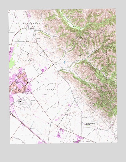
Natividad, CA USGS Topographic Map
Click on map above to begin viewing in our Map Viewer.

This topographic map contains these locations and features:
Feature Name Type Latitude Longitude GNIS ID View Map
AlisalPopulated PlaceN36.6791°W121.6177°1693202View Map
Alisal Community SchoolSchoolN36.6822°W121.6046°218127View Map
Alisal High SchoolSchoolN36.6846°W121.6002°218126View Map
Bardin Elementary SchoolSchoolN36.6735°W121.6004°218662View Map
California Shock Trauma Air Rescue - CALSTAR 5 Air Ambulance SalinasBuildingN36.6652°W121.6124°2662312View Map
Camp McCallumLocaleN36.6425°W121.5347°220471View Map
Camp McCallum Post Office (historical)Post OfficeN36.6425°W121.5347°2026819View Map
Cesar E Chavez Elementary SchoolSchoolN36.6876°W121.6041°2504426View Map
Closter ParkParkN36.6811°W121.6152°221233View Map
Creekside Elementary SchoolSchoolN36.7053°W121.6110°2504439View Map
Dr Martin Luther King Jr Elementary AcademySchoolN36.6863°W121.6170°2504529View Map
Dunn CanyonValleyN36.7022°W121.5344°222731View Map
El AlisalCivilN36.6727°W121.5836°223016View Map
El AlisalCivilN36.6600°W121.5513°223017View Map
El Sausal Middle SchoolSchoolN36.6735°W121.6238°223058View Map
Everett Alvarez High SchoolSchoolN36.7126°W121.6161°1873318View Map
Frank Paul Elementary SchoolSchoolN36.6949°W121.6072°1873324View Map
Frank Paul ParkParkN36.6941°W121.6074°1873325View Map
Fremont Elementary SchoolSchoolN36.6765°W121.6191°223881View Map
Gabilan Creek Wilderness SanctuaryParkN36.7091°W121.6211°1873326View Map
Gene Robertson ParkParkN36.6711°W121.6183°1873328View Map
Hartnell CollegeSchoolN36.6725°W121.6077°224982View Map
Jesse G Sanchez Elementary SchoolSchoolN36.6853°W121.6178°2504461View Map
John E Steinbeck Elementary SchoolSchoolN36.7086°W121.6173°1873331View Map
KCTY-AM (Salinas)TowerN36.7088°W121.6138°1662710View Map
KOQI-AM (Soquel)TowerN36.6605°W121.5424°1662759View Map
KPUP-AM (Carmel Valley)TowerN36.6605°W121.5424°1662586View Map
KRAY-FM (Salinas)TowerN36.7088°W121.6138°1663036View Map
KTGE-AM (Salinas)TowerN36.6969°W121.6238°1662711View Map
KTGE-AM (Salinas)TowerN36.6605°W121.5424°1662712View Map
KTOM-AM (Salinas)TowerN36.6969°W121.6238°1662714View Map
La NatividadCivilN36.7413°W121.5922°226714View Map
Lagunita Elementary SchoolSchoolN36.7494°W121.6219°1873335View Map
Llano De Buena VistaCivilN36.6372°W121.6230°227439View Map
Loma Vista Elementary SchoolSchoolN36.7085°W121.6228°227493View Map
Los Padres Elementary SchoolSchoolN36.6705°W121.6220°227684View Map
Los Padres ParkParkN36.6708°W121.6211°1873337View Map
Monterey County Parks and Flood Control OfficeBuildingN36.6944°W121.6241°1873340View Map
Monterey County Public Works CenterLocaleN36.6922°W121.6249°1873341View Map
Monterey County Sheriff Posse Grounds and AreaLocaleN36.7336°W121.6036°1873342View Map
NatividadPopulated PlaceN36.7327°W121.5966°252747View Map
Oscar F Loya Elementary SchoolSchoolN36.6894°W121.5948°2504528View Map
Saint Marys SchoolSchoolN36.6802°W121.6122°232223View Map
Salinas Air Base (historical)AirportN36.6697°W121.6180°1693217View Map
Salinas DivisionCivilN36.7048°W121.5931°1935278View Map
Salinas Fairways Golf CourseLocaleN36.6691°W121.6194°1654262View Map
Salinas Fire Department Station 4BuildingN36.6763°W121.6122°2624171View Map
Salinas Fire Department Station 5BuildingN36.6961°W121.6035°2624373View Map
Salinas Municipal AirportAirportN36.6648°W121.6118°252381View Map
Sanborn Elementary SchoolSchoolN36.6850°W121.6186°232483View Map
SausalCivilN36.7044°W121.6174°232601View Map
Steinbeck ParkParkN36.7069°W121.6166°1873365View Map
Virginia Rocca Barton Elementary SchoolSchoolN36.6954°W121.6162°1873368View Map

Note: Coordinates in the location and feature list above are referenced to NAD83 datum.


Copyright (C) 2008-2024 Ryan Niemi / Sunset Dynamics ... All Rights Reserved