TopoQuest Logo
Do you find TopoQuest useful?
Help keep TopoQuest running and adding new maps/features by donating!
Bitcoin:  19c7KJd3qBynnjoSw5npx9KScwjBe4ifkT
Litecoin:  LXs6TkuXGGXo1vDsWCkWVdjQX94eUKd6ui
Home View Maps Find Maps Find Places Resources & Links


Mount Sneffels, Colorado Topographic Map

USGS Map Title: Mount Sneffels, CO
USGS Map MRC: 38107A7
DRG (GeoTIFF) Download: o38107a7.tif


Neighboring USGS Topographic Map Quads:


  Horsefly Peak, CO  
38107B8
 

  Ridgway, CO  
38107B7
 

  Dallas, CO  
38107B6
 

  Sams, CO  
38107A8
 

  Mount Sneffels, CO  
38107A7
 

  Ouray, CO  
38107A6
 

  Gray Head, CO  
37107H8
 

  Telluride, CO  
37107H7
 

  Ironton, CO  
37107H6


Map MRC Location:

N39°
W108°
N39°
W107°
H8 H7 H6 H5 H4 H3 H2 H1
G8 G7 G6 G5 G4 G3 G2 G1
F8 F7 F6 F5 F4 F3 F2 F1
E8 E7 E6 E5 E4 E3 E2 E1
D8 D7 D6 D5 D4 D3 D2 D1
C8 C7 C6 C5 C4 C3 C2 C1
B8 B7 B6 B5 B4 B3 B2 B1
A8 A7 A6 A5 A4 A3 A2 A1
N38°
W108°
N38°
W107°

Mount Sneffels, CO USGS 1:24K Topographic Map Preview:
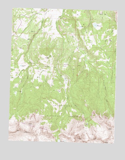
Mount Sneffels, CO USGS Topographic Map
Click on map above to begin viewing in our Map Viewer.

This topographic map contains these locations and features:
Feature Name Type Latitude Longitude GNIS ID View Map
Beaver CreekStreamN38.1180°W107.8181°188597View Map
Billy Wood SpringSpringN38.1215°W107.7690°188591View Map
Blaine BasinBasinN38.0180°W107.7826°188566View Map
Blaine DrawValleyN38.0907°W107.7974°188587View Map
Blaine MineMineN38.0144°W107.7853°196893View Map
Blue LakesLakeN38.0008°W107.8109°203291View Map
Blue Lakes TrailTrailN38.0203°W107.8209°203292View Map
Box Factory ParkFlatN38.0461°W107.8612°188579View Map
Cannon DitchCanalN38.0767°W107.7592°188594View Map
Carrol Brown ReservoirReservoirN38.0700°W107.8673°200903View Map
Carroll Brown DamDamN38.0700°W107.8673°200902View Map
Cirque MountainSummitN38.0039°W107.7717°188596View Map
Cocan FlatsFlatN38.0480°W107.8165°188569View Map
Cottonwood CreekStreamN38.1197°W107.8353°188563View Map
Dallas TrailTrailN38.0514°W107.8615°203361View Map
Dry LakeLakeN38.1203°W107.7996°188588View Map
Elder MeadowFlatN38.0722°W107.8103°188571View Map
Gibson SpringSpringN38.0803°W107.8270°188575View Map
Groff SpringSpringN38.0969°W107.7591°188560View Map
Homer Brown SpringSpringN38.0706°W107.8292°188573View Map
Hout SpringSpringN38.1213°W107.7660°188592View Map
Kelly CampLocaleN38.0761°W107.7603°188595View Map
Kettle CampLocaleN38.0703°W107.8217°188572View Map
Kettle GulchValleyN38.1125°W107.7519°188565View Map
Lake OtonawandaReservoirN38.1108°W107.7764°188590View Map
Lower Desert TankReservoirN38.1033°W107.8523°188586View Map
McClure CampLocaleN38.0594°W107.8717°188582View Map
Mears PeakSummitN38.0092°W107.8617°188577View Map
Miller MesaSummitN38.0836°W107.7698°203351View Map
Mount RidgwaySummitN38.0136°W107.7531°188564View Map
Mount SneffelsSummitN38.0033°W107.7923°196432View Map
Mount Sneffels WildernessReserveN38.0116°W107.8739°197188View Map
Mud SpringSpringN38.0874°W107.8649°188583View Map
Otonowanda DamDamN38.1122°W107.7784°200908View Map
Ridgway Town DitchCanalN38.0822°W107.7603°188593View Map
Ruby Trust MineMineN38.0197°W107.8006°1745605View Map
South BaldySummitN38.0789°W107.8331°188574View Map
Stough DrawValleyN38.0679°W107.8552°188562View Map
Teakettle MountainSummitN38.0008°W107.7617°188567View Map
Ulah Brown SpringSpringN38.0708°W107.8623°188581View Map
Upper Desert TankReservoirN38.0956°W107.8563°188584View Map
Vance CreekStreamN38.0733°W107.8512°188576View Map
Vance PlaceLocaleN38.0600°W107.8415°188580View Map
West Fork West Dallas CreekStreamN38.0625°W107.8551°188561View Map
West LakeLakeN38.1091°W107.7937°188589View Map
Willow SwampSwampN38.0591°W107.8092°188570View Map
Wilson CreekStreamN38.0428°W107.8073°188568View Map
Wolcott MountainSummitN38.0161°W107.8473°188578View Map

Note: Coordinates in the location and feature list above are referenced to NAD83 datum.


Copyright (C) 2008-2024 Ryan Niemi / Sunset Dynamics ... All Rights Reserved