TopoQuest Logo
Do you find TopoQuest useful?
Help keep TopoQuest running and adding new maps/features by donating!
Bitcoin:  19c7KJd3qBynnjoSw5npx9KScwjBe4ifkT
Litecoin:  LXs6TkuXGGXo1vDsWCkWVdjQX94eUKd6ui
Home View Maps Find Maps Find Places Resources & Links


Mount Shasta, California Topographic Map

USGS Map Title: Mount Shasta, CA
USGS Map MRC: 41122D2
DRG (GeoTIFF) Download: o41122d2.tif


Neighboring USGS Topographic Map Quads:


  Juniper Flat, CA  
41122E3
 

  The Whaleback, CA  
41122E2
 

  West Haight Mountain, CA  
41122E1
 

  Hotlum, CA  
41122D3
 

  Mount Shasta, CA  
41122D2
 

  Ash Creek Butte, CA  
41122D1
 

  City of Mount Shasta, CA  
41122C3
 

  McCloud, CA  
41122C2
 

  Elk Spring, CA  
41122C1


Map MRC Location:

N42°
W123°
N42°
W122°
H8 H7 H6 H5 H4 H3 H2 H1
G8 G7 G6 G5 G4 G3 G2 G1
F8 F7 F6 F5 F4 F3 F2 F1
E8 E7 E6 E5 E4 E3 E2 E1
D8 D7 D6 D5 D4 D3 D2 D1
C8 C7 C6 C5 C4 C3 C2 C1
B8 B7 B6 B5 B4 B3 B2 B1
A8 A7 A6 A5 A4 A3 A2 A1
N41°
W123°
N41°
W122°

Mount Shasta, CA USGS 1:24K Topographic Map Preview:
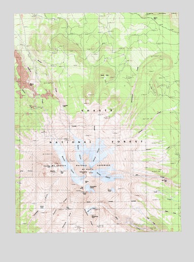
Mount Shasta, CA USGS Topographic Map
Click on map above to begin viewing in our Map Viewer.

This topographic map contains these locations and features:
Feature Name Type Latitude Longitude GNIS ID View Map
Ash Creek FallsFallsN41.4040°W122.1364°1657846View Map
Bolam GlacierGlacierN41.4153°W122.2004°257326View Map
Clarence King LakeLakeN41.4126°W122.2244°258395View Map
Clear CreekStreamN41.3757°W122.1408°258426View Map
Coquette FallsFallsN41.4471°W122.2147°258711View Map
Helen LakeLakeN41.3888°W122.2101°261235View Map
Hidden ValleyBasinN41.3888°W122.2303°1657862View Map
Hotlum GlacierGlacierN41.4202°W122.1879°261559View Map
Konwakiton GlacierGlacierN41.3997°W122.1954°262238View Map
Military PassGapN41.4943°W122.1436°263571View Map
Misery HillSummitN41.4054°W122.1981°1657869View Map
Mount ShastaSummitN41.4093°W122.1950°266054View Map
Mount Shasta Natural LandmarkParkN41.4140°W122.1995°1657870View Map
Mount Shasta WildernessReserveN41.4208°W122.2066°2035211View Map
Mud Creek GlacierGlacierN41.3879°W122.1942°1657873View Map
North GateGapN41.4604°W122.1853°264222View Map
Red BanksRidgeN41.4007°W122.1986°265254View Map
Sargents RidgeRidgeN41.3813°W122.1939°265849View Map
Shastarama PointSummitN41.3849°W122.1939°1657878View Map
ShastinaSummitN41.4090°W122.2236°266055View Map
Sisson LakeLakeN41.4099°W122.2170°266216View Map
Sulphur SpringsSpringN41.4092°W122.1962°1657881View Map
The HeartAreaN41.3988°W122.2056°1657861View Map
Thumb RockPillarN41.3965°W122.2047°268263View Map
Watkins GlacierGlacierN41.3991°W122.1773°1657882View Map
Whitney FallsFallsN41.4613°W122.2400°269048View Map
Whitney GlacierGlacierN41.4140°W122.2113°269049View Map
Wintun GlacierGlacierN41.4078°W122.1823°269256View Map

Note: Coordinates in the location and feature list above are referenced to NAD83 datum.


Copyright (C) 2008-2024 Ryan Niemi / Sunset Dynamics ... All Rights Reserved