TopoQuest Logo
Do you find TopoQuest useful?
Help keep TopoQuest running and adding new maps/features by donating!
Bitcoin:  19c7KJd3qBynnjoSw5npx9KScwjBe4ifkT
Litecoin:  LXs6TkuXGGXo1vDsWCkWVdjQX94eUKd6ui
Home View Maps Find Maps Find Places Resources & Links


Mount Elbert, Colorado Topographic Map

USGS Map Title: Mount Elbert, CO
USGS Map MRC: 39106A4
DRG (GeoTIFF) Download: o39106a4.tif


Neighboring USGS Topographic Map Quads:


  Mount Champion, CO  
39106B5
 

  Mount Massive, CO  
39106B4
 

  Leadville South, CO  
39106B3
 

  Independence Pass, CO  
39106A5
 

  Mount Elbert, CO  
39106A4
 

  Granite, CO  
39106A3
 

  Pieplant, CO  
38106H5
 

  Winfield, CO  
38106H4
 

  Mount Harvard, CO  
38106H3


Map MRC Location:

N40°
W107°
N40°
W106°
H8 H7 H6 H5 H4 H3 H2 H1
G8 G7 G6 G5 G4 G3 G2 G1
F8 F7 F6 F5 F4 F3 F2 F1
E8 E7 E6 E5 E4 E3 E2 E1
D8 D7 D6 D5 D4 D3 D2 D1
C8 C7 C6 C5 C4 C3 C2 C1
B8 B7 B6 B5 B4 B3 B2 B1
A8 A7 A6 A5 A4 A3 A2 A1
N39°
W107°
N39°
W106°

Mount Elbert, CO USGS 1:24K Topographic Map Preview:
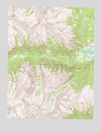
Mount Elbert, CO USGS Topographic Map
Click on map above to begin viewing in our Map Viewer.

This topographic map contains these locations and features:
Feature Name Type Latitude Longitude GNIS ID View Map
Arlington DitchCanalN39.0644°W106.4281°202698View Map
Bartlett MineMineN39.1008°W106.4084°196805View Map
Bengal Tiger MineMineN39.0850°W106.4036°1684883View Map
Black Cloud CreekStreamN39.0689°W106.4367°180390View Map
Boswell GulchValleyN39.0684°W106.3771°180415View Map
Bull HillSummitN39.0994°W106.4622°180376View Map
Casco PeakSummitN39.1142°W106.4939°180377View Map
Cozart DamDamN39.1033°W106.3822°198998View Map
Cozart ReservoirReservoirN39.1026°W106.3816°198999View Map
Crystal LakeLakeN39.0178°W106.4579°180408View Map
Crystal Lake CreekStreamN39.0705°W106.4572°180373View Map
Dayton GulchValleyN39.0796°W106.3816°180410View Map
Echo CanyonValleyN39.0723°W106.4685°180394View Map
Echo CreekStreamN39.0711°W106.4678°180379View Map
Edna May MineMineN39.0833°W106.3839°1684878View Map
Ellingwood RidgeRidgeN39.0486°W106.4667°180392View Map
Ervin PeakSummitN39.0036°W106.4384°2013629View Map
Fidelity MineMineN39.0922°W106.4572°180382View Map
Galena GulchValleyN39.0658°W106.4253°180370View Map
Golden Fleece MineMineN39.0897°W106.4628°180375View Map
Gordon GulchValleyN39.0805°W106.3896°180411View Map
Gordon MineMineN39.0847°W106.4047°180385View Map
Hayden GulchValleyN39.0716°W106.4821°180380View Map
Helen H Cochran MineMineN39.0761°W106.4342°1684885View Map
Iron Mike MineMineN39.1175°W106.4831°180378View Map
Kosmon MineMineN39.0833°W106.3839°1684879View Map
La Plata BasinBasinN39.0414°W106.4734°180372View Map
La Plata GulchValleyN39.0636°W106.4955°180371View Map
La Plata PeakSummitN39.0294°W106.4729°180393View Map
Last Chance MineMineN39.0836°W106.4659°180374View Map
Lily PondLakeN39.1096°W106.3870°180388View Map
Little Joe MineMineN39.0878°W106.4092°180387View Map
Little Willis GulchValleyN39.0497°W106.3924°180404View Map
Main Range TrailTrailN39.1008°W106.3884°180367View Map
Monitor GulchValleyN39.0722°W106.4474°180391View Map
Monitor RockSummitN39.0739°W106.4514°180395View Map
Mount BlaurockSummitN39.0111°W106.4536°2013628View Map
Mount CosgriffSummitN39.0969°W106.4256°1989389View Map
Mount ElbertSummitN39.1176°W106.4453°180381View Map
Mount Elbert TrailTrailN39.1211°W106.4206°180383View Map
Mount HopeSummitN39.0211°W106.4197°180405View Map
North Fork Lake CreekStreamN39.0655°W106.4998°180106View Map
Parry PeakSummitN39.0842°W106.4139°180386View Map
Parry Peak CampgroundLocaleN39.0680°W106.4100°180400View Map
Practical Gold Mining MineMineN39.0833°W106.3839°1684880View Map
Quail MountainSummitN39.0180°W106.3947°180403View Map
Rinker PeakSummitN39.0367°W106.4397°196426View Map
Rocky Point MineMineN39.0833°W106.3839°1684881View Map
Smith GulchValleyN39.0675°W106.4154°180389View Map
Snyder FallsFallsN39.0696°W106.4443°180396View Map
Sunset GulchValleyN39.0644°W106.4100°180369View Map
Sunset MineMineN39.0592°W106.4170°180402View Map
Twin LakesPopulated PlaceN39.0828°W106.3820°180384View Map
Twin PeaksSummitN39.0422°W106.4234°180399View Map
Twin Peaks CampgroundLocaleN39.0678°W106.4214°180398View Map
Vesuvius MineMineN39.0711°W106.4311°180397View Map
White Star MineMineN39.0814°W106.4095°180401View Map
Willis GulchValleyN39.0670°W106.3899°180406View Map
Willis LakeLakeN39.0216°W106.4360°180407View Map

Note: Coordinates in the location and feature list above are referenced to NAD83 datum.


Copyright (C) 2008-2024 Ryan Niemi / Sunset Dynamics ... All Rights Reserved