TopoQuest Logo
Do you find TopoQuest useful?
Help keep TopoQuest running and adding new maps/features by donating!
Bitcoin:  19c7KJd3qBynnjoSw5npx9KScwjBe4ifkT
Litecoin:  LXs6TkuXGGXo1vDsWCkWVdjQX94eUKd6ui
Home View Maps Find Maps Find Places Resources & Links


Mount Chase, Maine Topographic Map

USGS Map Title: Mount Chase, ME
USGS Map MRC: 46068A4
DRG (GeoTIFF) Download: o46068a4.tif


Neighboring USGS Topographic Map Quads:


  Hay Brook Mountain, ME  
46068B5
 

  Green Mountain, ME  
46068B4
 

  Knowles Corner, ME  
46068B3
 

  Shin Pond, ME  
46068A5
 

  Mount Chase, ME  
46068A4
 

  Island Falls, ME  
46068A3
 

  Lookout Mountain, ME  
45068H5
 

  Patten, ME  
45068H4
 

  Crystal, ME  
45068H3


Map MRC Location:

N47°
W69°
N47°
W68°
H8 H7 H6 H5 H4 H3 H2 H1
G8 G7 G6 G5 G4 G3 G2 G1
F8 F7 F6 F5 F4 F3 F2 F1
E8 E7 E6 E5 E4 E3 E2 E1
D8 D7 D6 D5 D4 D3 D2 D1
C8 C7 C6 C5 C4 C3 C2 C1
B8 B7 B6 B5 B4 B3 B2 B1
A8 A7 A6 A5 A4 A3 A2 A1
N46°
W69°
N46°
W68°

Mount Chase, ME USGS 1:24K Topographic Map Preview:
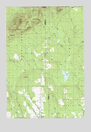
Mount Chase, ME USGS Topographic Map
Click on map above to begin viewing in our Map Viewer.

This topographic map contains these locations and features:
Feature Name Type Latitude Longitude GNIS ID View Map
Allsbury SchoolSchoolN46.0648°W68.4806°561212View Map
Bald MountainSummitN46.1018°W68.4647°561522View Map
Bear MountainSummitN46.1211°W68.4145°561852View Map
Bragg BrookStreamN46.0520°W68.4095°562876View Map
Crystal CemeteryCemeteryN46.0200°W68.3779°2678673View Map
Crystal LakeLakeN46.0476°W68.4036°564633View Map
Davis MountainSummitN46.1105°W68.4530°564817View Map
Davis SchoolSchoolN46.0800°W68.4353°564826View Map
Hale BrookStreamN46.0845°W68.3809°567435View Map
Halls CornerPopulated PlaceN46.1239°W68.3961°579381View Map
HerseyPopulated PlaceN46.0734°W68.4342°581998View Map
Hersey CemeteryCemeteryN46.0922°W68.4249°2678623View Map
Houston BrookStreamN46.0539°W68.4003°568365View Map
Kimball HillSummitN46.0448°W68.4684°569178View Map
Long MountainSummitN46.1150°W68.4630°570255View Map
Mill BrookStreamN46.0845°W68.4173°571307View Map
Mount ChaseSummitN46.1085°W68.4779°571760View Map
Myrick SchoolSchoolN46.0570°W68.4423°572032View Map
Patten AcademySchoolN46.0009°W68.4459°573063View Map
Patten CemeteryCemeteryN46.0046°W68.4474°2736936View Map
Patten Lumbermans MuseumBuildingN46.0014°W68.4681°1913799View Map
Peasley BrookReservoirN46.0019°W68.4751°1774435View Map
Peasley Brook DamDamN46.0019°W68.4751°1774434View Map
Rowe BrookStreamN46.0000°W68.4778°574540View Map
Sargent BrookStreamN46.0545°W68.4434°574919View Map
Seams BrookStreamN46.0842°W68.3811°575125View Map
Wardsworth MountainSummitN46.0932°W68.4958°577834View Map
Willett BrookStreamN46.0550°W68.4536°578506View Map

Note: Coordinates in the location and feature list above are referenced to NAD83 datum.


Copyright (C) 2008-2024 Ryan Niemi / Sunset Dynamics ... All Rights Reserved