TopoQuest Logo
Do you find TopoQuest useful?
Help keep TopoQuest running and adding new maps/features by donating!
Bitcoin:  19c7KJd3qBynnjoSw5npx9KScwjBe4ifkT
Litecoin:  LXs6TkuXGGXo1vDsWCkWVdjQX94eUKd6ui
Home View Maps Find Maps Find Places Resources & Links


Mount Bonneville, Wyoming Topographic Map

USGS Map Title: Mount Bonneville, WY
USGS Map MRC: 42109G3
DRG (GeoTIFF) Download: o42109g3.tif


Neighboring USGS Topographic Map Quads:


  Halls Mountain, WY  
42109H4
 

  Roberts Mountain, WY  
42109H3
 

  Washakie Park, WY  
42109H2
 

  Raid Lake, WY  
42109G4
 

  Mount Bonneville, WY  
42109G3
 

  Lizard Head Peak, WY  
42109G2
 

  Pocket Creek Lake, WY  
42109F4
 

  Big Sandy Opening, WY  
42109F3
 

  Temple Peak, WY  
42109F2


Map MRC Location:

N43°
W110°
N43°
W109°
H8 H7 H6 H5 H4 H3 H2 H1
G8 G7 G6 G5 G4 G3 G2 G1
F8 F7 F6 F5 F4 F3 F2 F1
E8 E7 E6 E5 E4 E3 E2 E1
D8 D7 D6 D5 D4 D3 D2 D1
C8 C7 C6 C5 C4 C3 C2 C1
B8 B7 B6 B5 B4 B3 B2 B1
A8 A7 A6 A5 A4 A3 A2 A1
N42°
W110°
N42°
W109°

Mount Bonneville, WY USGS 1:24K Topographic Map Preview:
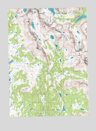
Mount Bonneville, WY USGS Topographic Map
Click on map above to begin viewing in our Map Viewer.

This topographic map contains these locations and features:
Feature Name Type Latitude Longitude GNIS ID View Map
Baptiste CreekStreamN42.8577°W109.2707°1597913View Map
Baptiste LakeLakeN42.8736°W109.3060°1597914View Map
Bears Ears TrailTrailN42.8330°W109.2510°1598033View Map
Bernard PeakSummitN42.8250°W109.2618°1598119View Map
Bonneville BasinBasinN42.8502°W109.3646°1598297View Map
Bonneville LakesLakeN42.8733°W109.3475°1598299View Map
Chilcoot LakeLakeN42.7585°W109.3423°1598730View Map
Crossover TrailTrailN42.8250°W109.3693°1604842View Map
Dads LakeLakeN42.7574°W109.2904°1599103View Map
Dike MountainSummitN42.8350°W109.2740°1599250View Map
Donald CreekStreamN42.7597°W109.2885°1599291View Map
Donald LakeLakeN42.7573°W109.2606°1599292View Map
East Park LakesLakeN42.8427°W109.3324°1599513View Map
Elizabeth LakeLakeN42.7747°W109.2867°1599570View Map
Grave LakeLakeN42.8627°W109.2558°1600049View Map
Hailey Pass TrailTrailN42.8133°W109.2954°1604821View Map
Haily PassGapN42.8463°W109.2887°1600162View Map
Hooker GlacierGlacierN42.8567°W109.3112°1600382View Map
Little Dads LakeLakeN42.7570°W109.2973°1604819View Map
Marms LakeLakeN42.7743°W109.2946°1604820View Map
Mays LakeLakeN42.8307°W109.2995°1601291View Map
Mount BonnevilleSummitN42.8719°W109.3396°1598300View Map
Mount GeikieSummitN42.8291°W109.3299°1599919View Map
Mount HookerSummitN42.8525°W109.3043°1600383View Map
Pilot KnobSummitN42.8638°W109.2662°1604816View Map
Pyramid LakeLakeN42.8413°W109.3057°1602331View Map
Pyramid Lake TrailTrailN42.8319°W109.3018°1604822View Map
Pyramid PeakSummitN42.8408°W109.2940°1602333View Map
Raid PeakSummitN42.8602°W109.3429°1602362View Map
Shadow Lake TrailTrailN42.7958°W109.2649°1604841View Map
Sheep LakeLakeN42.8315°W109.3541°1602848View Map
Skull LakeLakeN42.8140°W109.2931°1602951View Map
Tower PeakSummitN42.8577°W109.3168°1603717View Map
Twin ButtesSummitN42.7816°W109.3501°1603821View Map
Twin LakesLakeN42.8420°W109.2878°1605601View Map
Washakie CreekStreamN42.7963°W109.3101°1603995View Map
Washakie PassGapN42.8200°W109.2612°1604000View Map
Washakie PeakSummitN42.8136°W109.2565°1604001View Map

Note: Coordinates in the location and feature list above are referenced to NAD83 datum.


Copyright (C) 2008-2024 Ryan Niemi / Sunset Dynamics ... All Rights Reserved