TopoQuest Logo
Do you find TopoQuest useful?
Help keep TopoQuest running and adding new maps/features by donating!
Bitcoin:  19c7KJd3qBynnjoSw5npx9KScwjBe4ifkT
Litecoin:  LXs6TkuXGGXo1vDsWCkWVdjQX94eUKd6ui
Home View Maps Find Maps Find Places Resources & Links


Mora, New Mexico Topographic Map

USGS Map Title: Mora, NM
USGS Map MRC: 35105H3
DRG (GeoTIFF) Download: o35105h3.tif


Neighboring USGS Topographic Map Quads:


  Holman, NM  
36105A4
 

  Comanche Peak, NM  
36105A3
 

  Lucero, NM  
36105A2
 

  Gascon, NM  
35105H4
 

  Mora, NM  
35105H3
 

  Rainsville, NM  
35105H2
 

  Rociada, NM  
35105G4
 

  Sapello, NM  
35105G3
 

  Lake Isabel, NM  
35105G2


Map MRC Location:

N36°
W106°
N36°
W105°
H8 H7 H6 H5 H4 H3 H2 H1
G8 G7 G6 G5 G4 G3 G2 G1
F8 F7 F6 F5 F4 F3 F2 F1
E8 E7 E6 E5 E4 E3 E2 E1
D8 D7 D6 D5 D4 D3 D2 D1
C8 C7 C6 C5 C4 C3 C2 C1
B8 B7 B6 B5 B4 B3 B2 B1
A8 A7 A6 A5 A4 A3 A2 A1
N35°
W106°
N35°
W105°

Mora, NM USGS 1:24K Topographic Map Preview:
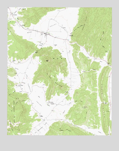
Mora, NM USGS Topographic Map
Click on map above to begin viewing in our Map Viewer.

This topographic map contains these locations and features:
Feature Name Type Latitude Longitude GNIS ID View Map
AbueloPopulated PlaceN35.9450°W105.3608°902945View Map
Aito del TaicoStreamN35.9703°W105.3550°2038790View Map
Alto De Las HerreraStreamN35.9834°W105.3570°899328View Map
Amola RidgeRidgeN35.9089°W105.2617°903141View Map
Bethel CemeteryCemeteryN35.8903°W105.3326°903770View Map
Brother of Jesus MissionChurchN35.9064°W105.2561°904095View Map
Caņada de AguaArroyoN35.9559°W105.2550°1852416View Map
Caņada de la Tierra BlancoStreamN35.9731°W105.3028°904349View Map
Caņada del AguaArroyoN35.9558°W105.2544°2574467View Map
CaņonPopulated PlaceN35.9431°W105.3700°920433View Map
Caņon del AguaValleyN35.9473°W105.2570°904562View Map
CanoncitoPopulated PlaceN35.9492°W105.2625°899329View Map
Capulin CreekStreamN35.8948°W105.3114°904760View Map
Capulin HillSummitN35.9023°W105.2847°904762View Map
Cassidy Mill Historic SiteLocaleN35.9742°W105.3295°933807View Map
CebollaLocaleN35.9459°W105.3700°933960View Map
Cebolla PassGapN35.9567°W105.3420°904857View Map
Chappell - Holman - Encinial - Ledoux Volunteer Fire StationBuildingN35.9943°W105.3714°2658033View Map
ClevelandPopulated PlaceN35.9934°W105.3706°915813View Map
Cleveland Post OfficePost OfficeN35.9934°W105.3706°937978View Map
Cleveland Roller Mill MuseumBuildingN35.9856°W105.3586°929482View Map
Comanche CanyonValleyN35.9936°W105.3672°905275View Map
CordilleraPopulated PlaceN35.9823°W105.3595°905337View Map
D Cassidy and Sons General MerchandiseBuildingN35.9933°W105.3700°933331View Map
Daniel Cassidy House Historic SiteBuildingN35.9742°W105.3300°933799View Map
David Cargo Public LibraryBuildingN35.9742°W105.3300°929350View Map
Desiderio Valdez House Historic SiteBuildingN35.9742°W105.3300°934305View Map
Eagle CreekStreamN35.9689°W105.3067°905928View Map
Eagle PeakSummitN35.9478°W105.3261°905938View Map
El AltoPopulated PlaceN35.9789°W105.3081°906028View Map
El OroLocaleN35.9234°W105.3333°915821View Map
El Oro MountainsRidgeN35.9289°W105.3192°906065View Map
El PosoSummitN35.9936°W105.2678°899330View Map
Garcia CanyonValleyN35.9214°W105.3620°906473View Map
Garcia House Historic SiteBuildingN35.9742°W105.3300°933733View Map
Gordon-Sanchez Mill Historic SiteLocaleN35.9742°W105.3300°933417View Map
Holman Elementary SchoolSchoolN35.9742°W105.3300°933897View Map
John Doherty House Historic SiteBuildingN35.9742°W105.3300°933590View Map
Jose Olguin Barn and Corral ComplexLocaleN35.9789°W105.3075°935791View Map
La Canada del GuajaloteStreamN35.9436°W105.2542°907616View Map
La Cebolla ValleyValleyN35.8911°W105.3086°915850View Map
La Loma del MudoSummitN35.9723°W105.3014°907674View Map
Las Quebraditas ValleyValleyN35.8900°W105.3217°907879View Map
Laumbachs CemeteryCemeteryN35.8986°W105.2535°907896View Map
LedouxPopulated PlaceN35.9236°W105.3614°907919View Map
Ledoux Post OfficePost OfficeN35.9239°W105.3614°938422View Map
Ledoux Rural Historic DistrictLocaleN35.9236°W105.3614°934306View Map
Ledoux Volunteer Fire DepartmentBuildingN35.9196°W105.3579°2657905View Map
Los Aguatas ValleyValleyN35.9678°W105.3058°899327View Map
Mica MineMineN35.9573°W105.3089°936800View Map
MoraPopulated PlaceN35.9742°W105.3300°915867View Map
Mora Beryl ProspectMineN35.9520°W105.3450°917253View Map
Mora Census Designated PlaceCensusN35.9633°W105.3312°2629121View Map
Mora County Sheriff's OfficeBuildingN35.9739°W105.3326°2722621View Map
Mora High SchoolSchoolN35.9742°W105.3300°901368View Map
Mora Historic DistrictLocaleN35.9742°W105.3300°934429View Map
Mora Post OfficePost OfficeN35.9742°W105.3300°938201View Map
Mora Presbyterian Church CemeteryCemeteryN35.9742°W105.3300°932435View Map
Mora ValleyAreaN35.9811°W105.3200°908894View Map
Mora Valley Community BaptistChurchN35.9934°W105.3706°920496View Map
Mora Valley Community Health Services AmbulanceBuildingN35.9783°W105.3547°2657668View Map
Mora Volunteer Fire DepartmentBuildingN35.9786°W105.3530°2657601View Map
North CarmenPopulated PlaceN35.9067°W105.3264°909128View Map
North Carmen Historic DistrictLocaleN35.9067°W105.3264°934389View Map
Our Lady of Mount Carmel ChurchChurchN35.9061°W105.3233°909399View Map
Presbyterian CemeteryCemeteryN35.9627°W105.3336°893468View Map
PuertocitoPopulated PlaceN35.9173°W105.3020°909892View Map
Quintana CemeteryCemeteryN35.9356°W105.3641°909941View Map
Rio la CasaStreamN35.9809°W105.3572°910228View Map
Rito MorphyStreamN35.9189°W105.3456°910306View Map
Romero HillsRangeN35.9848°W105.2822°920678View Map
Sacred Heart ChapelChurchN35.9473°W105.3697°910508View Map
Saint Gertrude CemeteryCemeteryN35.9645°W105.3328°910523View Map
Saint James ChapelChurchN35.9631°W105.3195°910525View Map
Saint Joseph CemeteryCemeteryN35.9176°W105.3613°910529View Map
Saint Joseph ChurchChurchN35.9498°W105.2717°910530View Map
Saint Vrain CemeteryCemeteryN35.9655°W105.3366°910540View Map
Saint Vrains MillLocaleN35.9742°W105.3300°936051View Map
San Antonio CemeteryCemeteryN35.9992°W105.3585°910596View Map
Santa Gertrudes CemeteryCemeteryN35.9742°W105.3300°932360View Map
Santa Gertrudis (historical)Populated PlaceN35.9639°W105.3325°915055View Map
Santiago CreekStreamN35.9189°W105.3456°910792View Map
South CarmenPopulated PlaceN35.8936°W105.3364°924763View Map
Tomas CanyonValleyN35.9089°W105.3497°911738View Map

Note: Coordinates in the location and feature list above are referenced to NAD83 datum.


Copyright (C) 2008-2024 Ryan Niemi / Sunset Dynamics ... All Rights Reserved