TopoQuest Logo
Do you find TopoQuest useful?
Help keep TopoQuest running and adding new maps/features by donating!
Bitcoin:  19c7KJd3qBynnjoSw5npx9KScwjBe4ifkT
Litecoin:  LXs6TkuXGGXo1vDsWCkWVdjQX94eUKd6ui
Home View Maps Find Maps Find Places Resources & Links


Monse, Washington Topographic Map

USGS Map Title: Monse, WA
USGS Map MRC: 48119B6
DRG (GeoTIFF) Download: o48119b6.tif


Neighboring USGS Topographic Map Quads:


  Chiliwist Valley, WA  
48119C7
 

  Malott, WA  
48119C6
 

  Okanogan, WA  
48119C5
 

  Rat Lake, WA  
48119B7
 

  Monse, WA  
48119B6
 

  White Lakes, WA  
48119B5
 

  Brewster, WA  
48119A7
 

  Bridgeport, WA  
48119A6
 

  Bridgeport Point, WA  
48119A5


Map MRC Location:

N49°
W120°
N49°
W119°
H8 H7 H6 H5 H4 H3 H2 H1
G8 G7 G6 G5 G4 G3 G2 G1
F8 F7 F6 F5 F4 F3 F2 F1
E8 E7 E6 E5 E4 E3 E2 E1
D8 D7 D6 D5 D4 D3 D2 D1
C8 C7 C6 C5 C4 C3 C2 C1
B8 B7 B6 B5 B4 B3 B2 B1
A8 A7 A6 A5 A4 A3 A2 A1
N48°
W120°
N48°
W119°

Monse, WA USGS 1:24K Topographic Map Preview:
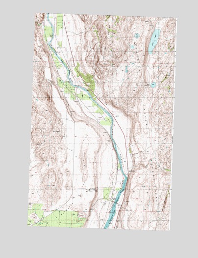
Monse, WA USGS Topographic Map
Click on map above to begin viewing in our Map Viewer.

This topographic map contains these locations and features:
Feature Name Type Latitude Longitude GNIS ID View Map
BJ LakeLakeN48.2384°W119.6598°1516009View Map
Brewster FlatFlatN48.1299°W119.7137°1516939View Map
Brewster Flat Earth StationBuildingN48.1476°W119.6964°1528824View Map
Coyote CanyonValleyN48.1310°W119.6370°1528823View Map
Crazy RapidsRapidsN48.1793°W119.6787°1518304View Map
Crazy Rapids ReservoirReservoirN48.1665°W119.6778°1532973View Map
Crazy Rapids Reservoir DamDamN48.1665°W119.6778°1532972View Map
Dan CanyonValleyN48.1674°W119.6403°1528826View Map
Davis CanyonValleyN48.2446°W119.7409°1518500View Map
Fort Okanogan Memorial CemeteryCemeteryN48.1593°W119.6645°1528825View Map
Little Soap LakeLakeN48.2102°W119.6437°1522308View Map
MonsePopulated PlaceN48.1413°W119.6778°1523325View Map
Okanogan County Fire District 8 Smith UnitBuildingN48.1311°W119.6373°2619690View Map
OphirPopulated PlaceN48.2090°W119.7178°1530601View Map
Soap LakeLakeN48.2371°W119.6438°1526074View Map
Thompson (historical)Populated PlaceN48.1393°W119.7484°1530590View Map
WakefieldPopulated PlaceN48.2024°W119.7103°1527760View Map

Note: Coordinates in the location and feature list above are referenced to NAD83 datum.


Copyright (C) 2008-2024 Ryan Niemi / Sunset Dynamics ... All Rights Reserved