TopoQuest Logo
Do you find TopoQuest useful?
Help keep TopoQuest running and adding new maps/features by donating!
Bitcoin:  19c7KJd3qBynnjoSw5npx9KScwjBe4ifkT
Litecoin:  LXs6TkuXGGXo1vDsWCkWVdjQX94eUKd6ui
Home View Maps Find Maps Find Places Resources & Links


Middleton, Texas Topographic Map

USGS Map Title: Middleton, TX
USGS Map MRC: 31095B7
DRG (GeoTIFF) Download: o31095b7.tif


Neighboring USGS Topographic Map Quads:


  Centerville, TX  
31095C8
 

  Eunice, TX  
31095C7
 

  Halls Bluff, TX  
31095C6
 

  Leona, TX  
31095B8
 

  Middleton, TX  
31095B7
 

  Austonio, TX  
31095B6
 

  Leona SW, TX  
31095A8
 

  Elwood, TX  
31095A7
 

  Sand Ridge, TX  
31095A6


Map MRC Location:

N32°
W96°
N32°
W95°
H8 H7 H6 H5 H4 H3 H2 H1
G8 G7 G6 G5 G4 G3 G2 G1
F8 F7 F6 F5 F4 F3 F2 F1
E8 E7 E6 E5 E4 E3 E2 E1
D8 D7 D6 D5 D4 D3 D2 D1
C8 C7 C6 C5 C4 C3 C2 C1
B8 B7 B6 B5 B4 B3 B2 B1
A8 A7 A6 A5 A4 A3 A2 A1
N31°
W96°
N31°
W95°

Middleton, TX USGS 1:24K Topographic Map Preview:
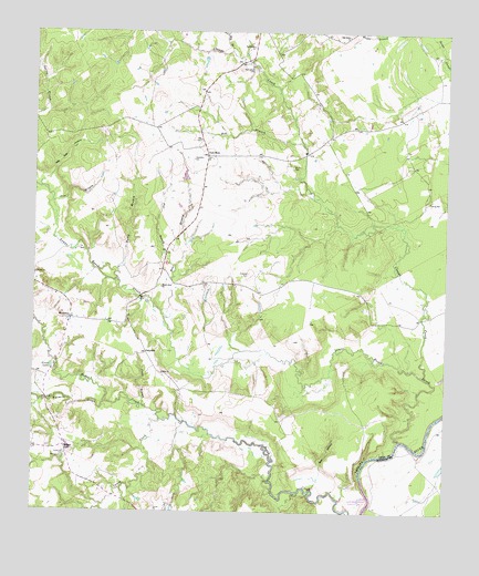
Middleton, TX USGS Topographic Map
Click on map above to begin viewing in our Map Viewer.

This topographic map contains these locations and features:
Feature Name Type Latitude Longitude GNIS ID View Map
Albert George Branch LibraryBuildingN31.1269°W95.8394°2015065View Map
Bear BranchStreamN31.1749°W95.8358°1351657View Map
Bob BranchStreamN31.2202°W95.7938°1352540View Map
Burton CemeteryCemeteryN31.2152°W95.7972°1353393View Map
Cairo ChurchChurchN31.1613°W95.8358°1353516View Map
CairomissLocaleN31.1663°W95.8411°1353519View Map
Caney CreekStreamN31.1491°W95.8366°1372919View Map
Clapps CreekStreamN31.1605°W95.7561°1354547View Map
Dry BranchStreamN31.2452°W95.8163°1356285View Map
Flat BranchStreamN31.1888°W95.8327°1357420View Map
Grass LakeLakeN31.1627°W95.8696°1358304View Map
Guys StoreLocaleN31.2180°W95.8227°1358536View Map
Guys StorePopulated PlaceN31.2202°W95.8244°2034941View Map
Haley BranchStreamN31.1849°W95.8511°1358642View Map
Holleman CemeteryCemeteryN31.1868°W95.8100°1359417View Map
Jones BranchStreamN31.1527°W95.8416°1360374View Map
Lower Keechi CreekStreamN31.1438°W95.7638°1374756View Map
MiddletonPopulated PlaceN31.1752°W95.8641°1380186View Map
Moore Ranch AirportAirportN31.2166°W95.8283°1386366View Map
Mount Airy ChurchChurchN31.1832°W95.8363°1363223View Map
New Salem CemeteryCemeteryN31.2399°W95.8091°1363772View Map
New Salem ChurchChurchN31.2463°W95.8094°1363775View Map
Oak Grove ChurchChurchN31.2491°W95.7805°1364274View Map
Pine BranchStreamN31.2049°W95.8700°1365264View Map
Pleasant Grove CemeteryCemeteryN31.1388°W95.8647°1365398View Map
Red HollowValleyN31.1362°W95.7877°1366170View Map
Red HollowValleyN31.1747°W95.8748°1366171View Map
Red Oak HollowValleyN31.2113°W95.8718°1366197View Map
Spillers StorePopulated PlaceN31.1419°W95.8661°2034935View Map
Spillers StoreLocaleN31.1410°W95.8647°1368907View Map
Spillerville CemeteryCemeteryN31.1399°W95.8650°1368908View Map
Taylor LakeReservoirN31.2102°W95.8286°1859055View Map
Taylor Lake DamDamN31.2102°W95.8286°1859054View Map
Thomason CemeteryCemeteryN31.2171°W95.8272°1369846View Map
Turkey Lake BranchStreamN31.2477°W95.8325°1370270View Map
Twomile CreekStreamN31.1532°W95.8530°1370403View Map

Note: Coordinates in the location and feature list above are referenced to NAD83 datum.


Copyright (C) 2008-2024 Ryan Niemi / Sunset Dynamics ... All Rights Reserved