TopoQuest Logo
Do you find TopoQuest useful?
Help keep TopoQuest running and adding new maps/features by donating!
Bitcoin:  19c7KJd3qBynnjoSw5npx9KScwjBe4ifkT
Litecoin:  LXs6TkuXGGXo1vDsWCkWVdjQX94eUKd6ui
Home View Maps Find Maps Find Places Resources & Links


Mellen, Wisconsin Topographic Map

USGS Map Title: Mellen, WI
USGS Map MRC: 46090C6
DRG (GeoTIFF) Download: o46090c6.tif


Neighboring USGS Topographic Map Quads:


  Marengo, WI  
46090D7
 

  High Bridge, WI  
46090D6
 

  Gurney, WI  
46090D5
 

  Mineral Lake, WI  
46090C7
 

  Mellen, WI  
46090C6
 

  Mount Whittlesey, WI  
46090C5
 

  Clam Lake NE, WI  
46090B7
 

  Morse, WI  
46090B6
 

  Glidden, WI  
46090B5


Map MRC Location:

N47°
W91°
N47°
W90°
H8 H7 H6 H5 H4 H3 H2 H1
G8 G7 G6 G5 G4 G3 G2 G1
F8 F7 F6 F5 F4 F3 F2 F1
E8 E7 E6 E5 E4 E3 E2 E1
D8 D7 D6 D5 D4 D3 D2 D1
C8 C7 C6 C5 C4 C3 C2 C1
B8 B7 B6 B5 B4 B3 B2 B1
A8 A7 A6 A5 A4 A3 A2 A1
N46°
W91°
N46°
W90°

Mellen, WI USGS 1:24K Topographic Map Preview:
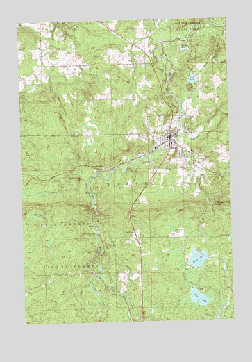
Mellen, WI USGS Topographic Map
Click on map above to begin viewing in our Map Viewer.

This topographic map contains these locations and features:
Feature Name Type Latitude Longitude GNIS ID View Map
Cayuga CemeteryCemeteryN46.2522°W90.6805°1578966View Map
City CreekStreamN46.3147°W90.6491°1579008View Map
City of MellenCivilN46.3239°W90.6607°1583688View Map
Conley LakeLakeN46.2726°W90.7047°1579034View Map
Copper FallsFallsN46.3730°W90.6399°1579041View Map
Copper Falls State ParkParkN46.3744°W90.6411°1579042View Map
Devils CreekStreamN46.3266°W90.6507°1579120View Map
Eagles PeakSummitN46.2980°W90.6324°1579171View Map
Eagles Rest ResortLocaleN46.2719°W90.6488°1837828View Map
Foster JunctionPopulated PlaceN46.3136°W90.7041°1579276View Map
Gravelly BrookStreamN46.2863°W90.7071°1579359View Map
Happy CreekStreamN46.2908°W90.7071°1579388View Map
Hardscrabble CreekStreamN46.2922°W90.7082°1579390View Map
Immanuel Lutheran ChurchChurchN46.3263°W90.6638°1837840View Map
Iron RiverStreamN46.2700°W90.7068°1579515View Map
Krause CreekStreamN46.3683°W90.6544°1579606View Map
Legion Memorial LibraryBuildingN46.3269°W90.6602°1837844View Map
Long LakeLakeN46.2595°W90.6459°1579740View Map
Loon LakeLakeN46.3502°W90.6463°1579754View Map
Meder LakeLakeN46.2758°W90.6459°1579855View Map
MellenPopulated PlaceN46.3255°W90.6610°1579857View Map
Mellen Area MuseumBuildingN46.3269°W90.6602°1838427View Map
Mellen City HallBuildingN46.3269°W90.6602°1838428View Map
Mellen Country ClubLocaleN46.3591°W90.6791°1581276View Map
Mellen Elementary SchoolSchoolN46.3235°W90.6598°2713238View Map
Mellen Fire and RescueBuildingN46.3261°W90.6616°2696722View Map
Mellen High SchoolSchoolN46.3235°W90.6599°1838429View Map
Mellen Police DepartmentBuildingN46.3269°W90.6601°2759807View Map
Mellen Technology Charter SchoolSchoolN46.3235°W90.6597°2713237View Map
Montreal CreekStreamN46.3263°W90.6555°1579904View Map
Murphy LakeLakeN46.3623°W90.6509°1579974View Map
Rocky RunStreamN46.3083°W90.7107°1580279View Map
Scott-Taylor CreekStreamN46.3716°W90.6285°1580369View Map
Squaw CreekStreamN46.2663°W90.7082°1580519View Map
Tafelski CreekStreamN46.3147°W90.6827°1580573View Map
Tannery TownPopulated PlaceN46.3191°W90.6538°1837856View Map
Town of MorseCivilN46.2772°W90.6735°1583754View Map
White CityPopulated PlaceN46.3283°W90.6524°1837861View Map
Wildwood Haven ResortLocaleN46.2613°W90.6430°1837862View Map

Note: Coordinates in the location and feature list above are referenced to NAD83 datum.


Copyright (C) 2008-2024 Ryan Niemi / Sunset Dynamics ... All Rights Reserved