TopoQuest Logo
Do you find TopoQuest useful?
Help keep TopoQuest running and adding new maps/features by donating!
Bitcoin:  19c7KJd3qBynnjoSw5npx9KScwjBe4ifkT
Litecoin:  LXs6TkuXGGXo1vDsWCkWVdjQX94eUKd6ui
Home View Maps Find Maps Find Places Resources & Links


McLemoresville, Tennessee Topographic Map

USGS Map Title: McLemoresville, TN
USGS Map MRC: 35088H5
DRG (GeoTIFF) Download: o35088h5.tif


Neighboring USGS Topographic Map Quads:


  Trezevant West, TN  
36088A6
 

  Trezevant East, TN  
36088A5
 

  Huntingdon, TN  
36088A4
 

  Atwood, TN  
35088H6
 

  McLemoresville, TN  
35088H5
 

  Palmer Shelter, TN  
35088H4
 

  Spring Creek, TN  
35088G6
 

  Cedar Grove, TN  
35088G5
 

  Clarksburg, TN  
35088G4


Map MRC Location:

N36°
W89°
N36°
W88°
H8 H7 H6 H5 H4 H3 H2 H1
G8 G7 G6 G5 G4 G3 G2 G1
F8 F7 F6 F5 F4 F3 F2 F1
E8 E7 E6 E5 E4 E3 E2 E1
D8 D7 D6 D5 D4 D3 D2 D1
C8 C7 C6 C5 C4 C3 C2 C1
B8 B7 B6 B5 B4 B3 B2 B1
A8 A7 A6 A5 A4 A3 A2 A1
N35°
W89°
N35°
W88°

McLemoresville, TN USGS 1:24K Topographic Map Preview:
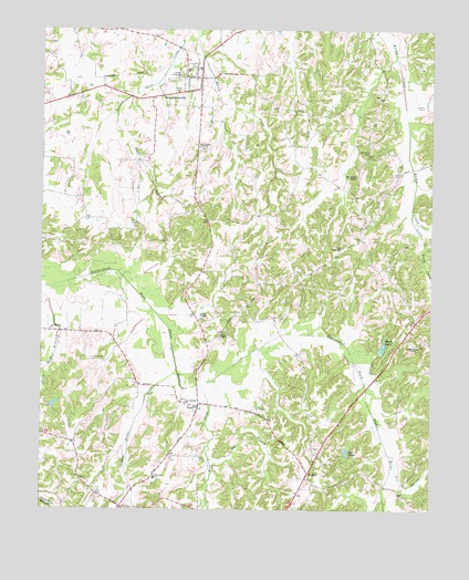
McLemoresville, TN USGS Topographic Map
Click on map above to begin viewing in our Map Viewer.

This topographic map contains these locations and features:
Feature Name Type Latitude Longitude GNIS ID View Map
Beech DamDamN35.9162°W88.5164°1307170View Map
Beech LakeReservoirN35.9176°W88.5154°1276852View Map
Carroll County Farm (historical)LocaleN35.9801°W88.5020°1320315View Map
Carroll County Rural Fire Department District 11 McLemoresvilleBuildingN35.9867°W88.5743°2653809View Map
Carroll County Rural Fire Department District 17 TerryBuildingN35.9018°W88.5741°2653733View Map
Carter ChapelChurchN35.9248°W88.5737°1326800View Map
Carters ChapelPopulated PlaceN35.9245°W88.5751°1326653View Map
Carters Chapel CemeteryCemeteryN35.9248°W88.5728°1326654View Map
Christian ChapelChurchN35.9176°W88.5045°1305922View Map
Christian Chapel CemeteryCemeteryN35.9181°W88.5039°1326656View Map
Commissioner District 1CivilN35.8850°W88.6223°2464214View Map
Cool Springs ChurchChurchN35.9028°W88.5787°1306089View Map
District 5 (historical)CivilN35.9751°W88.5667°1325878View Map
District 8 (historical)CivilN35.9667°W88.5014°1325881View Map
Full Gospel MissionChurchN35.9620°W88.5242°1285014View Map
Gin BranchStreamN35.8895°W88.5131°1285444View Map
Grassy Hollow CreekStreamN35.9120°W88.5814°1285900View Map
Holmes Store (historical)LocaleN35.8756°W88.5992°1320331View Map
HowleyPopulated PlaceN35.8845°W88.5392°1288570View Map
Howley School (historical)SchoolN35.8878°W88.5420°1320335View Map
Little Grove CemeteryCemeteryN35.9139°W88.6095°1291518View Map
Little Grove ChurchChurchN35.9220°W88.6217°1291519View Map
Little Reedy CreekStreamN35.9526°W88.5062°1291632View Map
McLemoresvillePopulated PlaceN35.9873°W88.5745°1293406View Map
McLemoresville Baptist ChurchChurchN35.9901°W88.5745°1320350View Map
McLemoresville CemeteryCemeteryN35.9895°W88.5781°1326668View Map
McLemoresville Collegiate Institute (historical)SchoolN35.9895°W88.5784°1646046View Map
McLemoresville Post OfficePost OfficeN35.9868°W88.5748°1651419View Map
McLemoresville School (historical)SchoolN35.9895°W88.5784°1320351View Map
Mill CreekStreamN35.9073°W88.5739°1293843View Map
Mount Olive CemeteryCemeteryN35.9684°W88.5200°1294694View Map
Nat BranchStreamN35.8881°W88.5706°1295249View Map
New Reedy Creek ChurchChurchN35.9692°W88.5748°1295629View Map
Obion ChapelChurchN35.9201°W88.5678°1296222View Map
Reedy Creek Baptist ChurchChurchN35.9881°W88.5812°1306947View Map
Robert Haney DamDamN35.9634°W88.5334°1302251View Map
Robert Haney LakeReservoirN35.9634°W88.5334°1302250View Map
TerryPopulated PlaceN35.9028°W88.5787°1304049View Map
Terry School (historical)SchoolN35.9034°W88.5803°1646056View Map
Town of McLemoresvilleCivilN35.9871°W88.5812°2406136View Map
Trezevant Division (historical)CensusN35.9817°W88.6226°1648631View Map
True TabernacleChurchN35.9434°W88.5287°1272920View Map
Twin LakesLakeN35.8899°W88.5268°1273120View Map
Westview SchoolSchoolN35.8831°W88.5884°1274258View Map

Note: Coordinates in the location and feature list above are referenced to NAD83 datum.


Copyright (C) 2008-2024 Ryan Niemi / Sunset Dynamics ... All Rights Reserved