TopoQuest Logo
Do you find TopoQuest useful?
Help keep TopoQuest running and adding new maps/features by donating!
Bitcoin:  19c7KJd3qBynnjoSw5npx9KScwjBe4ifkT
Litecoin:  LXs6TkuXGGXo1vDsWCkWVdjQX94eUKd6ui
Home View Maps Find Maps Find Places Resources & Links


Marshall, North Carolina Topographic Map

USGS Map Title: Marshall, NC
USGS Map MRC: 35082G6
DRG (GeoTIFF) Download: o35082g6.tif


Neighboring USGS Topographic Map Quads:


  Hot Springs, NC  
35082H7
 

  White Rock, NC  
35082H6
 

  Sams Gap, NC  
35082H5
 

  Spring Creek, NC  
35082G7
 

  Marshall, NC  
35082G6
 

  Mars Hill, NC  
35082G5
 

  Sandymush, NC  
35082F7
 

  Leicester, NC  
35082F6
 

  Weaverville, NC  
35082F5


Map MRC Location:

N36°
W83°
N36°
W82°
H8 H7 H6 H5 H4 H3 H2 H1
G8 G7 G6 G5 G4 G3 G2 G1
F8 F7 F6 F5 F4 F3 F2 F1
E8 E7 E6 E5 E4 E3 E2 E1
D8 D7 D6 D5 D4 D3 D2 D1
C8 C7 C6 C5 C4 C3 C2 C1
B8 B7 B6 B5 B4 B3 B2 B1
A8 A7 A6 A5 A4 A3 A2 A1
N35°
W83°
N35°
W82°

Marshall, NC USGS 1:24K Topographic Map Preview:
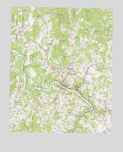
Marshall, NC USGS Topographic Map
Click on map above to begin viewing in our Map Viewer.

This topographic map contains these locations and features:
Feature Name Type Latitude Longitude GNIS ID View Map
Allman BranchStreamN35.7568°W82.6685°1008696View Map
Allman HollowValleyN35.8422°W82.6784°1008697View Map
Ammons BranchStreamN35.8326°W82.6671°1008710View Map
Anderson BranchStreamN35.8312°W82.7485°1008718View Map
Anderson Branch ChurchChurchN35.8201°W82.7474°1018818View Map
Antioch ChurchChurchN35.7518°W82.6887°1008753View Map
Appletree BranchStreamN35.8623°W82.6640°1008762View Map
Bailey BranchStreamN35.7918°W82.7010°1008845View Map
Baldwin CemeteryCemeteryN35.8687°W82.7007°1008885View Map
Ball CemeteryCemeteryN35.7637°W82.6996°1008891View Map
Barnard KnobSummitN35.8270°W82.7201°1023564View Map
Barnett MountainSummitN35.8254°W82.7232°1008939View Map
Bear CreekStreamN35.7940°W82.7165°1008993View Map
Bear Creek ChurchChurchN35.7876°W82.7154°1018999View Map
Bear Creek ChurchChurchN35.7723°W82.7168°1008998View Map
Bee BranchStreamN35.8384°W82.6571°1019041View Map
Big BranchStreamN35.8143°W82.6912°1009268View Map
Big CoveValleyN35.8215°W82.7473°1009294View Map
Blennerhassett IslandIslandN35.7965°W82.6874°1009475View Map
Boyd BranchStreamN35.7607°W82.7446°1019269View Map
Bradmon ChapelChurchN35.7793°W82.6940°1019276View Map
Bryan CemeteryCemeteryN35.8173°W82.6415°1009706View Map
Bryan GapGapN35.8084°W82.6751°1009707View Map
Bryant CemeteryCemeteryN35.8251°W82.6574°1009708View Map
Byard GapGapN35.8140°W82.6793°1009870View Map
Caney ForkStreamN35.7793°W82.7368°1019515View Map
Caney Fork ChurchChurchN35.7793°W82.7382°1010016View Map
Capps CemeteryCemeteryN35.8404°W82.6568°1010031View Map
Casey Bow BranchStreamN35.7926°W82.6754°1010086View Map
Chandler GapGapN35.8384°W82.6982°1010165View Map
Dan Payne MountainSummitN35.7523°W82.7290°1010642View Map
Davis ChapelChurchN35.8148°W82.6915°1010689View Map
Dockery RidgeRidgeN35.7590°W82.7190°1010845View Map
Dry BranchStreamN35.8134°W82.7062°1010910View Map
Dry Branch ChurchChurchN35.8134°W82.7062°1010913View Map
Dry Pond CemeteryCemeteryN35.7787°W82.7254°1010921View Map
Elbow HollowValleyN35.8600°W82.7490°1011038View Map
Emiline RidgeRidgeN35.7982°W82.7362°1011084View Map
Enon ChurchChurchN35.8334°W82.6657°1011099View Map
Frisby BranchStreamN35.7982°W82.6885°1011398View Map
Gahagan CemeteryCemeteryN35.8718°W82.7337°1011424View Map
Grand View ChurchChurchN35.7551°W82.6471°1011594View Map
Gunter CoveValleyN35.7604°W82.7446°1011778View Map
Hayes RunStreamN35.7923°W82.6699°1011928View Map
Hayes Run ChurchChurchN35.7926°W82.6690°1011929View Map
Heck CreekStreamN35.8618°W82.6662°1011957View Map
Heck Creek CemeteryCemeteryN35.8707°W82.6510°1011958View Map
Henderson CemeteryCemeteryN35.8184°W82.7054°1011969View Map
High RockSummitN35.8676°W82.6893°1012046View Map
Highrock RidgeRidgeN35.8487°W82.6924°1020772View Map
Hopewell BranchStreamN35.8490°W82.7493°1012170View Map
Hopewell RidgeRidgeN35.8676°W82.7404°1012176View Map
Hunter CreekStreamN35.8554°W82.6699°1020864View Map
Indian Grave GapGapN35.8409°W82.6887°1012346View Map
Indian Grave Gap BranchStreamN35.8409°W82.6715°1012349View Map
Ivy CreekStreamN35.7768°W82.6479°1012383View Map
Kalamazoo ChurchChurchN35.7848°W82.7379°1021010View Map
Laurel BranchStreamN35.7704°W82.6926°1012705View Map
Laurel Fork ChurchChurchN35.7698°W82.6918°1012737View Map
Lisenbee RidgeRidgeN35.8546°W82.6540°1012898View Map
Little Pine CreekStreamN35.7898°W82.7274°1013000View Map
Long BranchStreamN35.7729°W82.6307°1013124View Map
Low GapGapN35.7948°W82.7404°1013225View Map
Madison CountyCivilN35.8580°W82.7058°1025834View Map
Madison County Ambulance ServiceBuildingN35.8045°W82.6592°2720703View Map
Madison County Sheriff's OfficeBuildingN35.8045°W82.6531°2769915View Map
Madison SeminarySchoolN35.8090°W82.6562°1013285View Map
MarshallPopulated PlaceN35.7973°W82.6840°1021355View Map
Marshall CemeteryCemeteryN35.8126°W82.6765°1013329View Map
Marshall Community Volunteer Fire DepartmentBuildingN35.7974°W82.6855°2639823View Map
Marshall Elementary SchoolSchoolN35.7959°W82.6871°1017618View Map
Marshall Police DepartmentBuildingN35.7960°W82.6815°2769610View Map
Marshall Post OfficePost OfficeN35.7967°W82.6826°2766594View Map
Marshall Primary SchoolSchoolN35.8132°W82.6960°1017616View Map
Marshall Watershed LakeReservoirN35.8737°W82.6785°1017309View Map
Mashburn GapGapN35.8109°W82.6912°1013352View Map
McCrary-Madison QuarryMineN35.7867°W82.6561°2649222View Map
McDevitt BranchStreamN35.8526°W82.7082°1013416View Map
McDevitt CemeteryCemeteryN35.8565°W82.7349°1013417View Map
McGee DamDamN35.8034°W82.6332°1017298View Map
McGee DamReservoirN35.8032°W82.6337°1017299View Map
Mount Zion ChurchChurchN35.7648°W82.6460°1013789View Map
Mulberry GapGapN35.8659°W82.7176°1013829View Map
NC Noname Two-Hundred Thirteen DamDamN35.8734°W82.6782°1017308View Map
Nocona SidingLocaleN35.8012°W82.7299°1013968View Map
Oak Hill ChurchChurchN35.7687°W82.6751°1021696View Map
Old Station CemeteryCemeteryN35.8312°W82.7082°1014105View Map
Old Station GapGapN35.8318°W82.7074°1014106View Map
Panhandle BranchStreamN35.7687°W82.6601°1014199View Map
Pawpaw CreekStreamN35.8112°W82.7351°1014267View Map
Payne CemeteryCemeteryN35.7693°W82.7415°1014275View Map
Pilot KnobSummitN35.7551°W82.6987°1021899View Map
Ponder BranchStreamN35.7518°W82.6740°1014571View Map
Price MountainSummitN35.8548°W82.7196°1022078View Map
Profitt BranchStreamN35.8004°W82.6576°1014654View Map
Ramsey CemeteryCemeteryN35.7840°W82.6968°1014725View Map
Ramsey CemeteryCemeteryN35.8257°W82.6749°1014726View Map
Rector BranchStreamN35.7873°W82.7157°1014780View Map
Rector CemeteryCemeteryN35.7773°W82.6612°1014782View Map
Rector CemeteryCemeteryN35.7887°W82.7429°1014783View Map
Rector ChapelChurchN35.7751°W82.6718°1022182View Map
Rector MountainSummitN35.8262°W82.6846°1022184View Map
Red Hill ChurchChurchN35.8443°W82.7071°1022194View Map
Red Hill KnobSummitN35.8529°W82.6421°1022195View Map
Redbud BranchStreamN35.7762°W82.7340°1014793View Map
RedmonPopulated PlaceN35.7957°W82.7171°1014796View Map
Redmon DamDamN35.7933°W82.7103°1014797View Map
Reems BranchStreamN35.7518°W82.6754°1014813View Map
Reese GapGapN35.8148°W82.6349°1014816View Map
Revis BranchStreamN35.7721°W82.6360°1014827View Map
Rice BranchStreamN35.8459°W82.7099°1014839View Map
Rice CemeteryCemeteryN35.8545°W82.6726°1014841View Map
Roberson CemeteryCemeteryN35.7704°W82.6782°1014954View Map
Roberts BranchStreamN35.7748°W82.7418°1022317View Map
Roberts CemeteryCemeteryN35.7612°W82.7424°1014958View Map
Roberts CemeteryCemeteryN35.8068°W82.6985°1014960View Map
Roberts CemeteryCemeteryN35.8534°W82.6671°1014961View Map
Roberts GapGapN35.8068°W82.6954°1014965View Map
Roberts MountainSummitN35.8037°W82.7040°1022318View Map
RollinsPopulated PlaceN35.7896°W82.6635°1022386View Map
Runnion CemeteryCemeteryN35.8476°W82.6774°1015128View Map
Sevenmile RidgeRidgeN35.8418°W82.6382°1022550View Map
Sprinkle BranchStreamN35.8454°W82.6726°1015751View Map
Sprouse CemeteryCemeteryN35.7623°W82.6387°1015753View Map
Station BranchStreamN35.8168°W82.7146°1015802View Map
Sweetwater BranchStreamN35.7943°W82.7112°1015985View Map
Thomas BranchStreamN35.8423°W82.7413°1016103View Map
Thomason CemeteryCemeteryN35.8484°W82.6290°1016114View Map
Tillery BranchStreamN35.7818°W82.6543°1016146View Map
Tillery CemeteryCemeteryN35.7834°W82.6449°1016147View Map
Town of MarshallCivilN35.7974°W82.6817°2406103View Map
Township 1, Marshall (historical)CivilN35.8118°W82.6854°1026912View Map
Township 1, North MarshallCivilN35.8170°W82.6598°2406932View Map
Township 1, South MarshallCivilN35.7674°W82.7369°2406933View Map
Tweed BranchStreamN35.8104°W82.6576°1016299View Map
WalnutPopulated PlaceN35.8495°W82.7388°1023108View Map
Walnut Community Volunteer Fire DepartmentBuildingN35.8438°W82.7292°2639432View Map
Walnut CreekPopulated PlaceN35.8473°W82.6712°1023110View Map
Walnut CreekStreamN35.8123°W82.7346°1016423View Map
Watershed MountainSummitN35.8726°W82.6737°1023125View Map
West Branch Walnut CreekStreamN35.8262°W82.6760°1016522View Map
West CemeteryCemeteryN35.8332°W82.6687°1016525View Map
Wild BranchStreamN35.8576°W82.6749°1016658View Map
Wild CemeteryCemeteryN35.8568°W82.6682°1016660View Map
Wilson BranchStreamN35.8543°W82.6262°1016713View Map
WMMH-AM (Marshall)TowerN35.8004°W82.6760°1018501View Map

Note: Coordinates in the location and feature list above are referenced to NAD83 datum.


Copyright (C) 2008-2024 Ryan Niemi / Sunset Dynamics ... All Rights Reserved