TopoQuest Logo
Do you find TopoQuest useful?
Help keep TopoQuest running and adding new maps/features by donating!
Bitcoin:  19c7KJd3qBynnjoSw5npx9KScwjBe4ifkT
Litecoin:  LXs6TkuXGGXo1vDsWCkWVdjQX94eUKd6ui
Home View Maps Find Maps Find Places Resources & Links


Bayville, New York Topographic Map

USGS Map Title: Bayville, NY
USGS Map MRC: 40073H5
DRG (GeoTIFF) Download: o40073h5.tif


Neighboring USGS Topographic Map Quads:


  Glenville, CT  
41073A6
 

  Stamford, CT  
41073A5
 

  Norwalk South, CT  
41073A4
 

  Mamaroneck, NY  
40073H6
 

  Bayville, NY  
40073H5
 

  Lloyd Harbor, NY  
40073H4
 

  Sea Cliff, NY  
40073G6
 

  Hicksville, NY  
40073G5
 

  Huntington, NY  
40073G4


Map MRC Location:

N41°
W74°
N41°
W73°
H8 H7 H6 H5 H4 H3 H2 H1
G8 G7 G6 G5 G4 G3 G2 G1
F8 F7 F6 F5 F4 F3 F2 F1
E8 E7 E6 E5 E4 E3 E2 E1
D8 D7 D6 D5 D4 D3 D2 D1
C8 C7 C6 C5 C4 C3 C2 C1
B8 B7 B6 B5 B4 B3 B2 B1
A8 A7 A6 A5 A4 A3 A2 A1
N40°
W74°
N40°
W73°

Bayville, NY USGS 1:24K Topographic Map Preview:
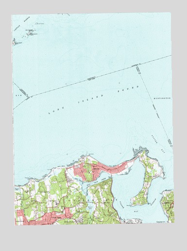
Bayville, NY USGS Topographic Map
Click on map above to begin viewing in our Map Viewer.

This topographic map contains these locations and features:
Feature Name Type Latitude Longitude GNIS ID View Map
Bailey Arboretum County ParkParkN40.8861°W73.5839°2075771View Map
BayvillePopulated PlaceN40.9107°W73.5621°943216View Map
Bayville Aquatic ClubLocaleN40.9050°W73.5486°2074783View Map
Bayville BridgeBridgeN40.9029°W73.5487°943217View Map
Bayville CemeteryCemeteryN40.9091°W73.5768°943218View Map
Bayville Church (historical)ChurchN40.9106°W73.5742°2074781View Map
Bayville Elementary SchoolSchoolN40.9061°W73.5631°2074691View Map
Bayville Fire DepartmentBuildingN40.9071°W73.5508°2369513View Map
Bayville Free LibraryBuildingN40.9089°W73.5667°2617216View Map
Bayville Post OfficePost OfficeN40.9075°W73.5508°2074652View Map
Bayville Rod and Gun ClubLocaleN40.9058°W73.5403°2075684View Map
Bayville Village HallBuildingN40.9106°W73.5728°2369514View Map
Beaver BrookStreamN40.8804°W73.5662°969857View Map
Beaver LakeReservoirN40.8851°W73.5655°943396View Map
Beckman Beach Town ParkParkN40.8772°W73.5286°2075774View Map
Beekman BeachBeachN40.8773°W73.5423°943545View Map
Brickyard PointCapeN40.8862°W73.5329°944719View Map
Bruce PointCapeN40.9021°W73.6081°2764517View Map
Centre IslandPopulated PlaceN40.9018°W73.5198°946329View Map
Centre IslandCapeN40.9001°W73.5204°973318View Map
Centre Island BeachBeachN40.9129°W73.5326°946330View Map
Centre Island Police DepartmentBuildingN40.9145°W73.5281°2781216View Map
Centre Island Police StationBuildingN40.9014°W73.5217°2074778View Map
Centre Island ReefBarN40.9176°W73.5271°946331View Map
Centre Island Town ParkParkN40.9100°W73.5342°2075779View Map
Cove NeckPopulated PlaceN40.8823°W73.5060°947571View Map
Cove PointCapeN40.8926°W73.5087°947572View Map
Creek Club BeachBeachN40.9053°W73.5972°2074777View Map
Cyrus PointCapeN40.9011°W73.5611°2369515View Map
East BeachBeachN40.8984°W73.6218°977328View Map
Ferry BeachBeachN40.9087°W73.5479°950007View Map
Fox PointCapeN40.9079°W73.5951°950578View Map
Frost CreekStreamN40.9023°W73.6087°950763View Map
Gebbs EstateLocaleN40.9044°W73.5867°2074784View Map
Glen Cove Center for Nursing and RehabilitationBuildingN40.8751°W73.6234°2614649View Map
Glen Cove Golf CourseLocaleN40.8919°W73.6242°2075702View Map
Great Captain Island LighthouseLocaleN40.9826°W73.6240°1942152View Map
Guther Boat HouseBuildingN40.9017°W73.6056°2074779View Map
Guther EstateLocaleN40.8978°W73.6042°2074785View Map
Island Swamp BrookStreamN40.8951°W73.6198°953836View Map
Jones Manor Adult HomeBuildingN40.9111°W73.5739°2075074View Map
Jones Manor on the Sound Assisted Living FacilityBuildingN40.9110°W73.5738°2614691View Map
Kentuck PondLakeN40.8828°W73.5724°954539View Map
LattingtownPopulated PlaceN40.8954°W73.6010°955075View Map
Little Captain IslandIslandN40.9887°W73.6115°1942406View Map
Locust ValleyPopulated PlaceN40.8759°W73.5971°955805View Map
Locust Valley CemeteryCemeteryN40.8836°W73.5880°2074780View Map
Locust Valley Census Designated PlaceCensusN40.8782°W73.5884°2390086View Map
Locust Valley Elementary SchoolSchoolN40.8825°W73.5872°2074708View Map
Locust Valley Fire StationBuildingN40.8782°W73.5894°2734832View Map
Locust Valley High SchoolSchoolN40.8879°W73.5921°955806View Map
Locust Valley LibraryBuildingN40.8781°W73.5908°2074749View Map
Locust Valley Post OfficePost OfficeN40.8753°W73.5992°2074667View Map
Locust Valley SchoolSchoolN40.8847°W73.5858°2074788View Map
MatinecockPopulated PlaceN40.8762°W73.5765°956671View Map
Meudon BeachBeachN40.9019°W73.6050°2074776View Map
Mill NeckCapeN40.8898°W73.5554°957255View Map
Mill NeckPopulated PlaceN40.8870°W73.5551°957256View Map
Mill Neck CreekStreamN40.9029°W73.5473°957257View Map
Mill Neck Manor SchoolSchoolN40.8795°W73.5587°957258View Map
Mill Neck PreserveParkN40.9042°W73.5786°2075801View Map
Mill Neck StationLocaleN40.8797°W73.5625°2074786View Map
Moses PointCapeN40.8868°W73.5210°957730View Map
OakCapeN40.9079°W73.5671°973397View Map
Oak Neck BeachBeachN40.9095°W73.5818°959139View Map
Oak Neck CreekGutN40.9020°W73.5757°959140View Map
Oak Neck PointCapeN40.9157°W73.5662°959141View Map
Oyster BayBayN40.8881°W73.5137°959717View Map
Oyster Bay HarborBayN40.8820°W73.5243°959720View Map
Oyster Bay National Wildlife RefugeParkN40.9057°W73.5045°971952View Map
Oyster Bay StationLocaleN40.8753°W73.5303°2075740View Map
Oyster Bay Yacht ClubLocaleN40.8769°W73.5394°2074787View Map
Peacock PointCapeN40.9020°W73.6126°970465View Map
Pine Island (historical)IslandN40.9086°W73.5406°2074789View Map
Plum PointCapeN40.9018°W73.5085°960768View Map
Pratt CemeteryCemeteryN40.8872°W73.6143°961093View Map
Reformed Church of Locust ValleyChurchN40.8837°W73.5873°2074782View Map
Rocky PointCapeN40.9179°W73.5226°962787View Map
Sagamore HillSummitN40.8840°W73.5010°963220View Map
Saint Gertrude's Roman Catholic ChurchChurchN40.9107°W73.5673°963530View Map
Saint Johns ChurchChurchN40.8890°W73.6082°963632View Map
Saint Josephats MonasteryChurchN40.8945°W73.6151°963710View Map
Seawanhaka - Corinthian Yacht ClubLocaleN40.9022°W73.5139°2075752View Map
Shu SwampSwampN40.8779°W73.5657°965184View Map
Shu Swamp Nature PreserveParkN40.8775°W73.5658°2075810View Map
Smith CemeteryCemeteryN40.8903°W73.5043°965459View Map
Soundside Beach ParkParkN40.9100°W73.5414°2075814View Map
Spring LakeLakeN40.8804°W73.5487°966071View Map
Stehli BeachBeachN40.9093°W73.5879°966339View Map
Stehli Town BeachParkN40.9089°W73.5839°2075816View Map
The Creek BeachBeachN40.9034°W73.6001°967228View Map
The Creek ClubLocaleN40.8932°W73.5976°2615072View Map
The Creek ClubLocaleN40.8892°W73.5967°2075762View Map
Theodore Roosevelt Memorial ParkParkN40.8765°W73.5332°966976View Map
Underhill CemeteryCemeteryN40.8907°W73.5739°968128View Map
Village of BayvilleCivilN40.9077°W73.5609°2391542View Map
Village of Centre IslandCivilN40.9019°W73.5209°2391596View Map
Village of LattingtownCivilN40.8921°W73.5966°2390933View Map
Village of Mill NeckCivilN40.8841°W73.5579°2390983View Map
Village Woods ParkParkN40.9078°W73.5650°2075820View Map
Wee Captain IslandIslandN40.9903°W73.6089°2558397View Map
West HarborBayN40.9001°W73.5296°971928View Map
West HarborBayN40.9012°W73.5782°973520View Map
West Harbor BeachBeachN40.9050°W73.5433°2075056View Map

Note: Coordinates in the location and feature list above are referenced to NAD83 datum.


Copyright (C) 2008-2024 Ryan Niemi / Sunset Dynamics ... All Rights Reserved