TopoQuest Logo
Do you find TopoQuest useful?
Help keep TopoQuest running and adding new maps/features by donating!
Bitcoin:  19c7KJd3qBynnjoSw5npx9KScwjBe4ifkT
Litecoin:  LXs6TkuXGGXo1vDsWCkWVdjQX94eUKd6ui
Home View Maps Find Maps Find Places Resources & Links


Manlius, New York Topographic Map

USGS Map Title: Manlius, NY
USGS Map MRC: 43075A8
DRG (GeoTIFF) Download: o43075a8.tif


Neighboring USGS Topographic Map Quads:


  Cicero, NY  
43076B1
 

  Cleveland, NY  
43075B8
 

  Jewell, NY  
43075B7
 

  Syracuse East, NY  
43076A1
 

  Manlius, NY  
43075A8
 

  Canastota, NY  
43075A7
 

  Jamesville, NY  
42076H1
 

  Oran, NY  
42075H8
 

  Cazenovia, NY  
42075H7


Map MRC Location:

N44°
W76°
N44°
W75°
H8 H7 H6 H5 H4 H3 H2 H1
G8 G7 G6 G5 G4 G3 G2 G1
F8 F7 F6 F5 F4 F3 F2 F1
E8 E7 E6 E5 E4 E3 E2 E1
D8 D7 D6 D5 D4 D3 D2 D1
C8 C7 C6 C5 C4 C3 C2 C1
B8 B7 B6 B5 B4 B3 B2 B1
A8 A7 A6 A5 A4 A3 A2 A1
N43°
W76°
N43°
W75°

Manlius, NY USGS 1:24K Topographic Map Preview:
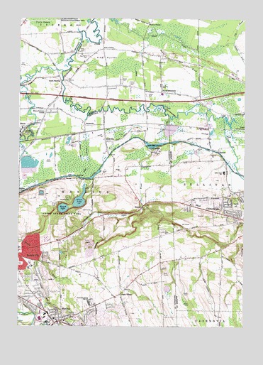
Manlius, NY USGS Topographic Map
Click on map above to begin viewing in our Map Viewer.

This topographic map contains these locations and features:
Feature Name Type Latitude Longitude GNIS ID View Map
Anguish Family CemeteryCemeteryN43.0519°W75.9025°2542807View Map
BolivarPopulated PlaceN43.0712°W75.8888°944402View Map
Bolivar Road Elementary SchoolSchoolN43.0626°W75.8862°944403View Map
Butternut CreekStreamN43.0981°W75.9996°942084View Map
C And M FarmLocaleN43.0992°W75.9947°2542012View Map
Chittenango Middle SchoolSchoolN43.0865°W75.8753°946598View Map
Chittenango Village Sewage Treatment PlantLocaleN43.0626°W75.8771°2597160View Map
Christ Episcopal ChurchChurchN43.0028°W75.9747°2492249View Map
Community Covenant ChurchChurchN43.0027°W75.9785°2615804View Map
Dry Hill Burial GroundCemeteryN43.0244°W75.9764°2542193View Map
Eagle VillagePopulated PlaceN43.0131°W75.9427°948944View Map
Edgebrook Mobile Home ParkPopulated PlaceN43.1114°W75.9656°2486393View Map
Erie Canal State ParkParkN43.0731°W75.9216°949683View Map
Fayetteville Post OfficePost OfficeN43.0314°W75.9981°2617915View Map
Fayetteville QuarryMineN43.0308°W75.9608°2548806View Map
Fayetteville United Methodist ChurchChurchN43.0319°W75.9972°2491718View Map
Fayetteville-Manlius High SchoolSchoolN43.0095°W75.9602°949944View Map
First Baptist ChurchChurchN43.0033°W75.9750°2492241View Map
First Baptist Church of ChittenangoChurchN43.0543°W75.8822°2597857View Map
Frank L Baum-Oz MuseumBuildingN43.0451°W75.8807°2035606View Map
Fyler CemeteryCemeteryN43.0950°W75.9139°2542808View Map
Fyler SettlementPopulated PlaceN43.0953°W75.9210°950827View Map
Gates CemeteryCemeteryN43.0278°W75.9025°2542809View Map
Gates Homestead FarmsLocaleN43.0289°W75.9094°2547247View Map
Green LakeLakeN43.0514°W75.9659°951701View Map
Green Lakes State ParkParkN43.0484°W75.9710°951705View Map
Honey Hill OrchardLocaleN43.0647°W75.9122°2542311View Map
Immaculate Conception CemeteryCemeteryN43.0300°W75.9983°2542187View Map
Immaculate Conception SchoolSchoolN43.0241°W75.9923°2669043View Map
Kinsella QuarryMineN43.0303°W75.9614°2712444View Map
KirkvillePopulated PlaceN43.0751°W75.9519°954714View Map
Kirkville CemeteryCemeteryN43.0742°W75.9478°2542190View Map
Kirkville Fire DepartmentBuildingN43.0718°W75.9513°2700998View Map
Kirkville Post OfficePost OfficeN43.0781°W75.9529°2780838View Map
Knox Hall (historical)BuildingN43.0006°W75.9650°2492240View Map
Lake BrookStreamN43.0834°W75.9633°954897View Map
Limestone CreekStreamN43.1034°W75.9758°955353View Map
ManliusPopulated PlaceN43.0020°W75.9769°956360View Map
Manlius Fire DepartmentBuildingN43.0051°W75.9850°2701045View Map
Manlius High School (historical)SchoolN43.0031°W75.9794°2492244View Map
Manlius LibraryBuildingN43.0038°W75.9845°2617341View Map
Manlius Post OfficePost OfficeN43.0025°W75.9777°2618011View Map
Manlius United Methodist ChurchChurchN43.0025°W75.9786°2492248View Map
Manlius Village CemeteryCemeteryN43.0025°W75.9697°2542192View Map
Manlius Village CentreBuildingN43.0039°W75.9846°2617642View Map
Manlius Village HallBuildingN43.0017°W75.9761°2492242View Map
Mohawk Manor Trailer ParkPopulated PlaceN43.0857°W75.8844°2598895View Map
MycenaePopulated PlaceN43.0490°W75.9305°958225View Map
Mycenae Burial GroundCemeteryN43.0494°W75.9294°2542191View Map
Negro BrookStreamN43.1181°W75.9202°958332View Map
North Chittenango Volunteer Fire CompanyBuildingN43.0877°W75.8768°2718350View Map
North Madison Baptist ChurchChurchN43.0541°W75.8799°2597869View Map
North ManliusPopulated PlaceN43.0998°W75.9771°958847View Map
Peck CornersLocaleN43.1126°W75.9530°960079View Map
Pennock DitchCanalN43.1115°W75.8782°960154View Map
Pine PlainsFlatN43.1112°W75.9452°960531View Map
Pine Plains CemeteryCemeteryN43.1101°W75.9613°960533View Map
Pools BrookStreamN43.0845°W75.9160°960916View Map
Poolsbrook AerodromeAirportN43.0724°W75.9390°978131View Map
Round LakeLakeN43.0478°W75.9753°962975View Map
Saint Agnes CemeteryCemeteryN43.0423°W75.8791°963248View Map
Saint Annes Roman Catholic ChurchChurchN43.0017°W75.9747°2492243View Map
Saint Patrick's ChurchChurchN43.0496°W75.9046°2597876View Map
SaintsvillePopulated PlaceN43.0820°W75.9635°973037View Map
Shady Lane Manufactured Housing CommunityPopulated PlaceN43.1006°W75.9435°2598896View Map
Skyridge Golf CourseLocaleN43.0426°W75.9101°2598911View Map
Snyder CrossingPopulated PlaceN43.0753°W75.9910°965596View Map
Tall Pines VillagePopulated PlaceN43.0947°W75.9289°2486394View Map
Thompson Hall (historical)BuildingN43.0003°W75.9639°2492239View Map
Town of ManliusCivilN43.0489°W75.9793°979192View Map
Town of Manlius Police DepartmentBuildingN43.0031°W75.9854°2780656View Map
Town of SullivanCivilN43.0922°W75.8794°979535View Map
Village of ManliusCivilN43.0015°W75.9819°2390961View Map
Weaver CornerPopulated PlaceN43.1228°W75.9277°973211View Map
Wilcox FarmsLocaleN43.0992°W75.9547°2542075View Map
Woodcrest Golf ClubLocaleN43.0249°W75.8964°2598912View Map
Wynwood of Manlius Assisted Living FacilityBuildingN43.0003°W75.9786°2614859View Map

Note: Coordinates in the location and feature list above are referenced to NAD83 datum.


Copyright (C) 2008-2024 Ryan Niemi / Sunset Dynamics ... All Rights Reserved