TopoQuest Logo
Do you find TopoQuest useful?
Help keep TopoQuest running and adding new maps/features by donating!
Bitcoin:  19c7KJd3qBynnjoSw5npx9KScwjBe4ifkT
Litecoin:  LXs6TkuXGGXo1vDsWCkWVdjQX94eUKd6ui
Home View Maps Find Maps Find Places Resources & Links


Baxter, Minnesota Topographic Map

USGS Map Title: Baxter, MN
USGS Map MRC: 46094C3
DRG (GeoTIFF) Download: o46094c3.tif


Neighboring USGS Topographic Map Quads:


  Wilson Bay, MN  
46094D4
 

  Gull Lake, MN  
46094D3
 

  Merrifield, MN  
46094D2
 

  Pillager, MN  
46094C4
 

  Baxter, MN  
46094C3
 

  Brainerd, MN  
46094C2
 

  Belle Prairie NW, MN  
46094B4
 

  Fort Ripley, MN  
46094B3
 

  Lastrup NW, MN  
46094B2


Map MRC Location:

N47°
W95°
N47°
W94°
H8 H7 H6 H5 H4 H3 H2 H1
G8 G7 G6 G5 G4 G3 G2 G1
F8 F7 F6 F5 F4 F3 F2 F1
E8 E7 E6 E5 E4 E3 E2 E1
D8 D7 D6 D5 D4 D3 D2 D1
C8 C7 C6 C5 C4 C3 C2 C1
B8 B7 B6 B5 B4 B3 B2 B1
A8 A7 A6 A5 A4 A3 A2 A1
N46°
W95°
N46°
W94°

Baxter, MN USGS 1:24K Topographic Map Preview:
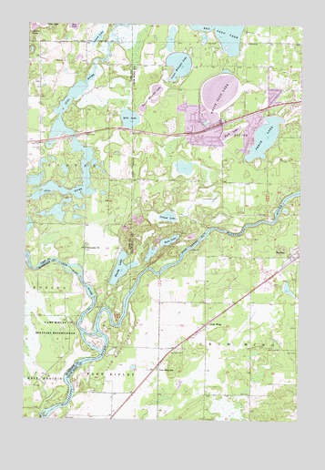
Baxter, MN USGS Topographic Map
Click on map above to begin viewing in our Map Viewer.

This topographic map contains these locations and features:
Feature Name Type Latitude Longitude GNIS ID View Map
BarrowsPopulated PlaceN46.3011°W94.2539°639649View Map
Barrows (historical)LocaleN46.3011°W94.2536°2071708View Map
Barrows Post Office (historical)Post OfficeN46.3011°W94.2536°2071707View Map
Bass LakeLakeN46.3067°W94.3099°639682View Map
BaxterPopulated PlaceN46.3433°W94.2867°639737View Map
BaxterLocaleN46.3417°W94.2925°2071773View Map
Baxter CemeteryCemeteryN46.3456°W94.2856°2071541View Map
Baxter City HallBuildingN46.3428°W94.2928°2071775View Map
Baxter Elementary SchoolSchoolN46.3444°W94.2860°2071774View Map
Baxter Police DepartmentBuildingN46.3431°W94.2936°2758798View Map
Christ Lutheran ChurchChurchN46.3514°W94.2667°2071753View Map
City of BaxterCivilN46.3424°W94.2798°2394086View Map
Community Behavioral Health Hospital BaxterHospitalN46.3592°W94.2575°2697223View Map
Crow WingPopulated PlaceN46.2800°W94.2925°642507View Map
Crow Wing (historical)LocaleN46.2800°W94.2922°2071703View Map
Crow Wing Post Office (historical)Post OfficeN46.2800°W94.2922°2071704View Map
Crow Wing RiverStreamN46.2711°W94.3397°655896View Map
Crow Wing SchoolSchoolN46.2658°W94.3142°642510View Map
Crow Wing State ParkParkN46.2722°W94.3333°2094130View Map
Family of Christ Lutheran SchoolSchoolN46.3694°W94.2647°2071770View Map
Fort Ripley Historical MarkerParkN46.2819°W94.2903°2094112View Map
Gull River CemeteryCemeteryN46.3355°W94.3689°644529View Map
Hardy LakeLakeN46.2976°W94.3323°644668View Map
Holmes Airfield (historical)AirportN46.2969°W94.2683°660082View Map
Island LakeLakeN46.3143°W94.3105°645478View Map
Lake Area Christian ChurchChurchN46.3314°W94.2597°2094034View Map
Lakewood Evangelical ChurchChurchN46.3494°W94.2667°2071749View Map
Little Pine Resort and CampgroundLocaleN46.3414°W94.3528°2071615View Map
Little Whipple LakeLakeN46.3705°W94.3101°2071732View Map
Lord of Life Lutheran ChurchChurchN46.3494°W94.2664°2071748View Map
Loren Thompson ParkParkN46.3408°W94.2786°2071772View Map
Lower Whipple LakeLakeN46.3622°W94.3065°647270View Map
Lynch LakeLakeN46.3707°W94.3438°647325View Map
Mile LakeLakeN46.3450°W94.3287°647840View Map
Mine LakeLakeN46.2916°W94.2554°2054879View Map
Oak Land CemeteryCemeteryN46.2721°W94.3053°648838View Map
Old Crow Wing Historical MarkerParkN46.2722°W94.3333°2094113View Map
Oscar Kristofferson ParkParkN46.3472°W94.2828°2071771View Map
Perch LakeLakeN46.3397°W94.2672°649286View Map
Perch Lake Trailer CourtPopulated PlaceN46.3478°W94.2639°2071747View Map
Plumly SchoolLocaleN46.2964°W94.3742°649596View Map
Prosser Farm Site CemeteryCemeteryN46.2722°W94.3486°2068620View Map
Red Sand LakeLakeN46.3749°W94.2874°649883View Map
Rush LakeLakeN46.3408°W94.2828°650401View Map
Saint Francis Assisi Catholic CemeteryCemeteryN46.2751°W94.3166°2071539View Map
Saint John Holy Cross Episcopal CemeteryCemeteryN46.2752°W94.3164°2071540View Map
United Pentecostal ChurchChurchN46.3314°W94.2506°2071754View Map
Upper Whipple LakeLakeN46.3504°W94.3187°653573View Map
White Sand LakeLakeN46.3527°W94.2880°654094View Map
WJJY-AM (Baxter)TowerN46.2986°W94.2786°663199View Map

Note: Coordinates in the location and feature list above are referenced to NAD83 datum.


Copyright (C) 2008-2024 Ryan Niemi / Sunset Dynamics ... All Rights Reserved