TopoQuest Logo
Do you find TopoQuest useful?
Help keep TopoQuest running and adding new maps/features by donating!
Bitcoin:  19c7KJd3qBynnjoSw5npx9KScwjBe4ifkT
Litecoin:  LXs6TkuXGGXo1vDsWCkWVdjQX94eUKd6ui
Home View Maps Find Maps Find Places Resources & Links


Agency Lake, Oregon Topographic Map

USGS Map Title: Agency Lake, OR
USGS Map MRC: 42121E8
DRG (GeoTIFF) Download: o42121e8.tif


Neighboring USGS Topographic Map Quads:


  Mares Egg Spring, OR  
42122F1
 

  Fort Klamath, OR  
42121F8
 

  Soloman Butte, OR  
42121F7
 

  Crystal Spring, OR  
42122E1
 

  Agency Lake, OR  
42121E8
 

  Chiloquin, OR  
42121E7
 

  Pelican Bay, OR  
42122D1
 

  Shoalwater Bay, OR  
42121D8
 

  Modoc Point, OR  
42121D7


Map MRC Location:

N43°
W122°
N43°
W121°
H8 H7 H6 H5 H4 H3 H2 H1
G8 G7 G6 G5 G4 G3 G2 G1
F8 F7 F6 F5 F4 F3 F2 F1
E8 E7 E6 E5 E4 E3 E2 E1
D8 D7 D6 D5 D4 D3 D2 D1
C8 C7 C6 C5 C4 C3 C2 C1
B8 B7 B6 B5 B4 B3 B2 B1
A8 A7 A6 A5 A4 A3 A2 A1
N42°
W122°
N42°
W121°

Agency Lake, OR USGS 1:24K Topographic Map Preview:
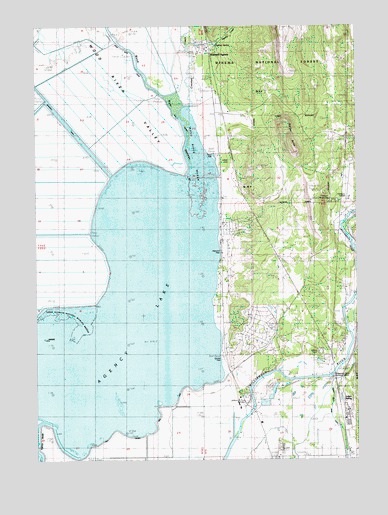
Agency Lake, OR USGS Topographic Map
Click on map above to begin viewing in our Map Viewer.

This topographic map contains these locations and features:
Feature Name Type Latitude Longitude GNIS ID View Map
Agency CreekStreamN42.6190°W121.9422°1137030View Map
Agency LakeLakeN42.5365°W121.9649°1161247View Map
Agency Lake ResortLocaleN42.5596°W121.9289°1867970View Map
Agency Lake Resort Boat RampLocaleN42.5598°W121.9290°2700251View Map
Agency Landing (historical)LocaleN42.5596°W121.9289°1154987View Map
Agency SpringSpringN42.6197°W121.9313°1154985View Map
B CanalCanalN42.6207°W121.9997°1154981View Map
Beetles Rest ReservoirReservoirN42.6198°W121.9319°1159017View Map
Bootleg PondReservoirN42.5957°W121.9400°1162559View Map
C CanalCanalN42.6193°W121.9928°1154982View Map
Chiloquin Agency Lake Fire District Station 2BuildingN42.5483°W121.9279°2576757View Map
Chiloquin Boat AccessLocaleN42.5706°W121.8790°2700259View Map
Chiloquin Ranger StationBuildingN42.5743°W121.8867°1134741View Map
Chiloquin State AirportAirportN42.5794°W121.8782°1161733View Map
Crooked CreekStreamN42.6085°W121.9428°1140467View Map
Henzel County ParkParkN42.5290°W121.9289°1162464View Map
Henzel Park Boat RampLocaleN42.5295°W121.9294°2700250View Map
Klamath AgencyPopulated PlaceN42.6182°W121.9339°1144657View Map
Klamath Agency Post Office (historical)Post OfficeN42.6182°W121.9339°1165492View Map
Lobert (historical)LocaleN42.5249°W121.8814°1154988View Map
Lobert CemeteryCemeteryN42.5860°W121.9255°1154986View Map
Miller PondReservoirN42.6124°W121.8900°1162560View Map
Modoc Point Main CanalCanalN42.5435°W121.8756°1146383View Map
Petric County ParkParkN42.5874°W121.9317°1162463View Map
Petric Park Boat RampLocaleN42.5879°W121.9314°2700249View Map
Rayenoof Field (historical)AirportN42.5954°W121.9364°1156406View Map
Sevenmile CanalCanalN42.5832°W121.9678°1154302View Map
Spring Creek HillSummitN42.6207°W121.9345°1154977View Map
Squaw CreekStreamN42.6012°W121.9470°1154983View Map
Steiger ButteSummitN42.5929°W121.9022°1150398View Map
Waterwheel Campground Boat LaunchLocaleN42.5240°W121.8877°2700260View Map
Williamson River MissionChurchN42.5162°W121.9186°1152399View Map
Williamson River Pumping PlantLocaleN42.5237°W121.8861°1163791View Map
Wilson CemeteryCemeteryN42.5307°W121.8903°1152450View Map
Wood RiverStreamN42.5854°W121.9428°1161600View Map
Wood River MarshSwampN42.5833°W121.9341°1154984View Map
Wood River ValleyValleyN42.5832°W121.9484°1134739View Map

Note: Coordinates in the location and feature list above are referenced to NAD83 datum.


Copyright (C) 2008-2024 Ryan Niemi / Sunset Dynamics ... All Rights Reserved