TopoQuest Logo
Do you find TopoQuest useful?
Help keep TopoQuest running and adding new maps/features by donating!
Bitcoin:  19c7KJd3qBynnjoSw5npx9KScwjBe4ifkT
Litecoin:  LXs6TkuXGGXo1vDsWCkWVdjQX94eUKd6ui
Home View Maps Find Maps Find Places Resources & Links


Leonards Point, North Carolina Topographic Map

USGS Map Title: Leonards Point, NC
USGS Map MRC: 35076H4
DRG (GeoTIFF) Download: o35076h4.tif


Neighboring USGS Topographic Map Quads:


  Edenton, NC  
36076A5
 

  Yeopim River, NC  
36076A4
 

  Harvey Neck, NC  
36076A3
 

  Roper North, NC  
35076H5
 

  Leonards Point, NC  
35076H4
 

  Columbia West, NC  
35076H3
 

  Roper South, NC  
35076G5
 

  Creswell, NC  
35076G4
 

  Creswell SE, NC  
35076G3


Map MRC Location:

N36°
W77°
N36°
W76°
H8 H7 H6 H5 H4 H3 H2 H1
G8 G7 G6 G5 G4 G3 G2 G1
F8 F7 F6 F5 F4 F3 F2 F1
E8 E7 E6 E5 E4 E3 E2 E1
D8 D7 D6 D5 D4 D3 D2 D1
C8 C7 C6 C5 C4 C3 C2 C1
B8 B7 B6 B5 B4 B3 B2 B1
A8 A7 A6 A5 A4 A3 A2 A1
N35°
W77°
N35°
W76°

Leonards Point, NC USGS 1:24K Topographic Map Preview:
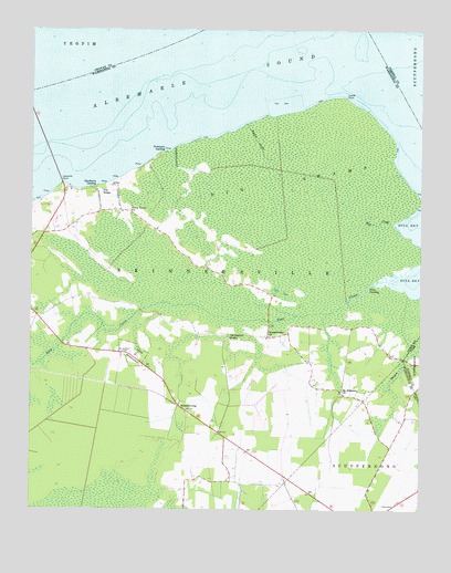
Leonards Point, NC USGS Topographic Map
Click on map above to begin viewing in our Map Viewer.

This topographic map contains these locations and features:
Feature Name Type Latitude Longitude GNIS ID View Map
Big SwampSwampN35.9544°W76.4153°981463View Map
Bull CreekStreamN35.9496°W76.3838°982206View Map
Davenport ForksPopulated PlaceN35.9196°W76.4360°1019910View Map
Deep CreekStreamN35.9349°W76.3855°984062View Map
First LandingLocaleN35.9329°W76.3913°1020252View Map
Indian SwampSwampN35.9058°W76.3839°1003434View Map
Laurel PointCapeN35.9827°W76.3994°988205View Map
Leonards PointCapeN35.9602°W76.4897°988364View Map
Mid - County Volunteer Fire DepartmentBuildingN35.9508°W76.4936°2638595View Map
Mount Pleasant ChurchChurchN35.9063°W76.3997°990544View Map
Newberry DitchCanalN35.9668°W76.4544°991118View Map
Newberry LandingLocaleN35.9685°W76.4569°1021641View Map
Pea RidgePopulated PlaceN35.9579°W76.4785°1021839View Map
Piney Grove ChurchChurchN35.9529°W76.4683°992359View Map
ScuppernongPopulated PlaceN35.9021°W76.4519°994447View Map
Scuppernong ChurchChurchN35.9199°W76.4233°994448View Map
Shadberry LandingLocaleN35.9593°W76.4791°1022555View Map
Sleights CreekStreamN35.9760°W76.4313°994912View Map
Sound (historical)LocaleN35.8802°W76.3913°1001121View Map
Spre Will ChapelChurchN35.9418°W76.4002°1018709View Map
Township of SkinnersvilleCivilN35.9031°W76.4865°1027293View Map

Note: Coordinates in the location and feature list above are referenced to NAD83 datum.


Copyright (C) 2008-2024 Ryan Niemi / Sunset Dynamics ... All Rights Reserved