TopoQuest Logo
Do you find TopoQuest useful?
Help keep TopoQuest running and adding new maps/features by donating!
Bitcoin:  19c7KJd3qBynnjoSw5npx9KScwjBe4ifkT
Litecoin:  LXs6TkuXGGXo1vDsWCkWVdjQX94eUKd6ui
Home View Maps Find Maps Find Places Resources & Links


Abbeville East, Alabama Topographic Map

USGS Map Title: Abbeville East, AL
USGS Map MRC: 31085E2
DRG (GeoTIFF) Download: o31085e2.tif


Neighboring USGS Topographic Map Quads:


  Lawrenceville, AL  
31085F3
 

  Fort Gaines NW, AL  
31085F2
 

  Fort Gaines NE, GA  
31085F1
 

  Abbeville West, AL  
31085E3
 

  Abbeville East, AL  
31085E2
 

  Fort Gaines, GA  
31085E1
 

  Newville, AL  
31085D3
 

  Haleburg, AL  
31085D2
 

  Columbia NE, GA  
31085D1


Map MRC Location:

N32°
W86°
N32°
W85°
H8 H7 H6 H5 H4 H3 H2 H1
G8 G7 G6 G5 G4 G3 G2 G1
F8 F7 F6 F5 F4 F3 F2 F1
E8 E7 E6 E5 E4 E3 E2 E1
D8 D7 D6 D5 D4 D3 D2 D1
C8 C7 C6 C5 C4 C3 C2 C1
B8 B7 B6 B5 B4 B3 B2 B1
A8 A7 A6 A5 A4 A3 A2 A1
N31°
W86°
N31°
W85°

Abbeville East, AL USGS 1:24K Topographic Map Preview:
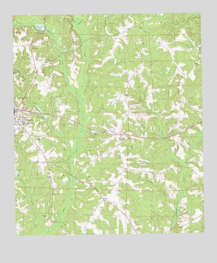
Abbeville East, AL USGS Topographic Map
Click on map above to begin viewing in our Map Viewer.

This topographic map contains these locations and features:
Feature Name Type Latitude Longitude GNIS ID View Map
Abbeville Fire and RescueBuildingN31.5705°W85.2477°2691225View Map
Abbeville Junior High SchoolSchoolN31.5638°W85.2410°132074View Map
Abbeville Methodist ChurchChurchN31.5696°W85.2497°147396View Map
Abbeville Municipal AirportAirportN31.5983°W85.2380°129408View Map
Abbeville Police DepartmentBuildingN31.5718°W85.2491°2751889View Map
Abbeville Post OfficePost OfficeN31.5714°W85.2484°2788970View Map
Bethel ChurchChurchN31.5574°W85.1830°114040View Map
Cat BranchStreamN31.6204°W85.2463°115690View Map
Cedar Grove ChurchChurchN31.5232°W85.2258°115783View Map
Chattahoochee Country Club and Golf Course (historical)LocaleN31.5599°W85.1838°132077View Map
Christ Temple Number Two ChurchChurchN31.5566°W85.1852°154633View Map
Davis BranchStreamN31.5674°W85.1538°117103View Map
Ebenezer CemeteryCemeteryN31.6127°W85.1802°117811View Map
Ebenezer Methodist Episcopal Church (historical)ChurchN31.6129°W85.1791°142977View Map
Edsel Adams DamDamN31.5702°W85.1633°129889View Map
Fincher PondReservoirN31.5106°W85.2293°118277View Map
First Baptist ChurchChurchN31.5685°W85.2491°147398View Map
Fleming BranchStreamN31.5163°W85.1430°118411View Map
G B Mathison DamDamN31.6168°W85.2283°129904View Map
Galloway BranchStreamN31.5741°W85.2052°118794View Map
Henry CountyCivilN31.5147°W85.2414°161559View Map
Henry County Sheriff's OfficeBuildingN31.5712°W85.2497°2752068View Map
Hickory Grove CemeteryCemeteryN31.5781°W85.2223°142978View Map
Hickory Grove ChurchChurchN31.5782°W85.2224°120028View Map
Little Abbie CreekStreamN31.5807°W85.2083°121685View Map
M L Tillis Pond DamDamN31.5585°W85.1983°129887View Map
Mathison LakeReservoirN31.6183°W85.2317°122385View Map
Merritts PondReservoirN31.5488°W85.1707°122671View Map
Messick PondReservoirN31.5555°W85.2325°122674View Map
Midway ChurchChurchN31.5329°W85.2260°122708View Map
Moneys PondReservoirN31.5966°W85.1273°122944View Map
Mount Zion ChurchChurchN31.5035°W85.1427°123444View Map
Mountain CreekStreamN31.5382°W85.1374°123507View Map
Nordan BranchStreamN31.5807°W85.2427°123969View Map
Old Zion Baptist ChurchChurchN31.5541°W85.1802°152806View Map
Old Zion CemeteryCemeteryN31.5538°W85.1802°142980View Map
Pilgrims Rest Freewill Baptist ChurchChurchN31.5727°W85.1738°155198View Map
Saint Paul ChurchChurchN31.6160°W85.1619°154643View Map
Saint Pauls SchoolSchoolN31.6154°W85.1610°126192View Map
Saint Peters CemeteryCemeteryN31.5699°W85.2413°126195View Map
Shorterville DivisionCivilN31.6147°W85.1465°165800View Map
Skippers CreekStreamN31.5018°W85.2294°126938View Map
Spring Hill ChurchChurchN31.6066°W85.2369°127247View Map
Starlings PondReservoirN31.5395°W85.1649°127321View Map
The Most Holy ChurchChurchN31.5971°W85.2302°132085View Map
Tillis PondReservoirN31.5586°W85.1970°153697View Map
Town CreekStreamN31.5804°W85.2424°128031View Map
UnionPopulated PlaceN31.5204°W85.1913°128260View Map
Union Freewill Baptist ChurchChurchN31.5196°W85.1913°142981View Map
Vann Mill CreekStreamN31.5463°W85.2113°153834View Map
Watford BranchStreamN31.6188°W85.2066°128628View Map
Wills CrossroadsPopulated PlaceN31.5563°W85.1797°129062View Map

Note: Coordinates in the location and feature list above are referenced to NAD83 datum.


Copyright (C) 2008-2024 Ryan Niemi / Sunset Dynamics ... All Rights Reserved